Japan in Northwest Thailand during World War II
| N19°22.40 E98°26.17[1] |
Pai[2] Airstrip (Th: ท่าอากาศยานปาย / Jp: パイー滑走路 ) |
Route 1095 |
| Text | Notes | ||||||||||||
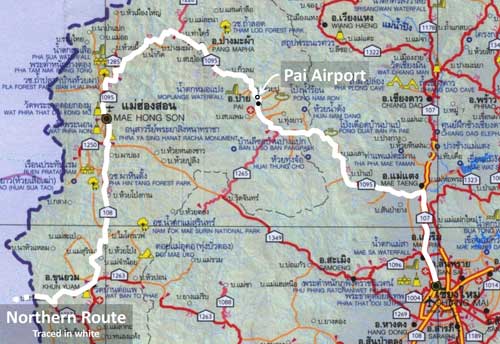
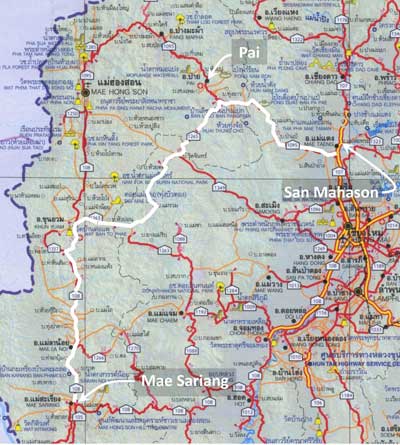
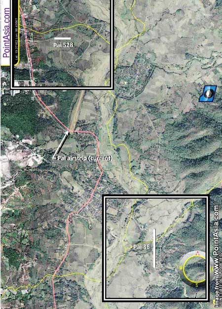
The map above[2a] shows the approximate location of the current day runway at Pai. No evidence has been found that air facilities existed at Pai during WWII. An airstrip at Pai is mentioned neither by Royal Thai Air Force histories,[3] nor by primary Japanese sources.[3a] Allied intelligence surveilled the area and noted road building activity towards the end of the war, but never reported the presence of a runway:
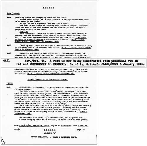
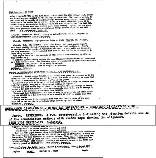
Allied intelligence noted a road under construction from Chiang Mai via Pai and Mae Hong Son into Burma:[4]
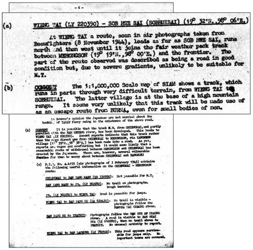
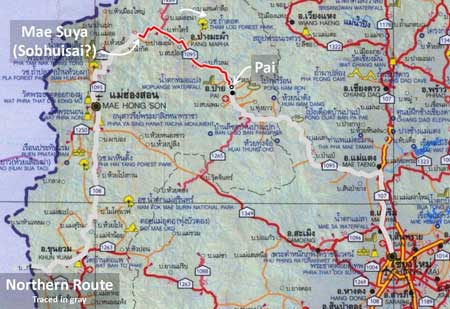
Allied intelligence further noted that Pai, under its alternate name, "Wieng Tai", was part of a development of IJA routes between northwest Thailand and Burma.[5] No mention is made of an airstrip at Pai. The village at the other end of this stretch, Sobhuisai, does not appear on modern maps, but the coordinates cited, N19°32 E98°06, place it in the area of present-day Ban Mae Suya (Route 1095: Station 168).
Pai, again called "Wieng Tai", is mentioned as part of an improbable route running southwest to Mae Sariang.[6] No mention is made of an air facility at Pai.
In any case, the point here is that Pai was seen as a key location in route planning, but an airport there was not deemed relevant throughout the war years (in contrast, see Khun Yuam Airstrip).
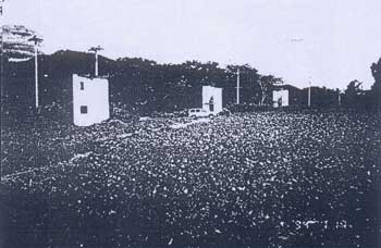
Two years after the war was over, Field Marshall Phibun flew into Pai to land at an airstrip at Tambun Wiang Nuea built specifically for his visit. Construction included three "cabins" (illustrated below) for accommodation of Phibun and staff.[7] Thus is established the origin of the airstrip.
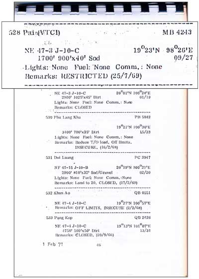
An Air America listing of facilities in Thailand includes two airstrips at Pai.[8]
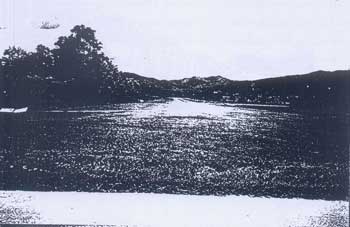
There is no evidence of either today. It is possible the listing was in error because the airstrip that was put in during 1947 and continues today as Pai Airport, was not included in this 1971 listing. 1994 A special report recorded this view, looking north, of the Pai airstrip:[10]
And in the airstrip, the three cabins that had been built for Phibun's visit in 1947:[11]
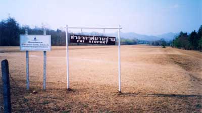
1999 A better view of the airstrip at a later date.[12] The sign in Thai reads: Royal Thai Air Force Property, Keep Out
AIRPORT CURRENT STATS[13] Name: Pai Airport - VTCI The runway was apparently first paved in 2006 or 2007 per Thai Flying Club photo captions; and by Feb 2011 featured an extension to the north.
|
See Key for interpreting page content. Revision list. See bottom of Text column on this page. Bibliography supports notes. 1.^ Coordinates are per Google Earth 2.^ Pai is the name of the amphoe (district). The village most closely associated with the runway is Wiang Nuea, or Wiengnua (เวียงเหนือ). 2a.^ The location map is taken from แผนที่ทางหลวงประเทสไทย Scale: 1:1,600,000 (กรุงเทพมหานคร:กรมทางหลวง, 2009)[Road Map of Thailand, Scale 1:1,600,000 (Bangkok: Department of Public Highways, 2009)], a folded map. Annotations are by author, using Microsoft Publisher. The northern route used by retreating IJA forces is here assumed to approximate currently existing roads. 3.^ บระวัติกองทัพอากาศไทย พ.ศ.๒๔๕๖ ๒๕๒๖ กองทัพอากาศ พุทธศักราช ๒๕๒๖, Royal Thai Air Force Official History 1913-1983 (Bangkok: Royal Thai Air Force, 1983). Also ประวัติศาสตร์การสงครามของไทย ในสงครามมหาเอเชียขูรพา กรมยุทธศึกษาทหาร กองบัญชาการทหารสูงสุด พ.ศ.๒๕๔๐, History of the Royal Thai Army during World War II (Bangkok: Royal Thai Army Command School, 1997). 3a.^ 戦史叢書 (東京: 防衛庁防衛研修所戦史室 (編集), ----年) [Senshi Sosho (Tokyo: Defense Agency, National Defense College Military History Room, various dates)] 4.^ "Siam-Roads & Railroads", Transportation Report: Road, Railroad, and Inland Waterways (China-Burma-India Joint Intelligence Collection Agency, 1-15 Jan 1945), p 26 (USAF Archive microfilm reel A8044 p 478). Karenni, or Karenni State, in Burma is now Kayah State, adjacent to Mae Hong Son Province, Thailand. Actually Allied intelligence understated the objective of the roadwork, which was Toungoo, a major transport hub in the Bago Region, more than 100 air km west of Karenni. 5.^ Communications in Siam, French Indo-China, & Yunnan, (?: Inter-service Topographic Department (SEAC), 01 Mar 1945),
5a.^ Source for the map is as noted in note 2a above.
6.^ "Siam-General", Transportation Report: Road, Railroad, and Inland Waterways (China-Burma-India Joint Intelligence Collection Agency, 1-15 Jul 1945), p 12 (USAF Archive microfilm reel A8044 p 760).
6a.^ Source for the map is as noted in note 2a above.
7.^ รายงาน การ สําร จอขุดค้น - 8.^ Air Facilities Data Thailand 432 (?: Air America?, 1971), pp 17, 46. See Key for interpreting page content.
9.^ PointAsia, accessed 06 Nov 2008. Annotations by author using Microsoft Publisher. The airstrips are located per Air America data which is accurate only to the whole minute. The squares around the two airstrips define the range of possible locations of the centerpoints of those airstrips as a function of the limited accuracy of the data --- that is, a half minute either side of the stated point. The dimensions of the 'squares' are 1 minute (latitude=1.15 mi or 1.84 km; longitude as a function of this latitude=1.08 mi or 1.74 km). They are rendered here as squares of 1.80 km. Source for dimensions is Table of Lat/Long equivalents in km and miles.
10.^ Report on Archaeological Research, Fig 64, p 101. While the report is dated 1999, the digital photo of the cabins (next) appears to have been taken in 1994 (see next footnote).
11.^ ibid, Fig 67, p 102. The photo appears to display a digital label "94", indicating it was taken in 1994, whereas the report was issued in 1999.
12.^ Photo courtesy of David Hardcastle, circa 1999, "looking north from public road end".
12a.^ The source would prefer not to be identified. There is no feature suggesting remnants of an airstrip. Slopes up to 8% on the site are too great to be practical. Entrance to the camp is at N19°22.51 E98°25.70. The camp is only about one kilometer west of the current airstrip and may simply have been identified with the camp at one time. 13.^ Thai Flying Club:
|
||||||||||||