| N19°16 E97°56 |
Mae Hong Son Airstrip |
Route 1095 |
| Text | Notes |
|
The IJA's Thai Occupation Army was established on this date, and three days later (07 Jan 1943) was put under the command of Southern Army Group. Sometime after, per direction of the Southern Army, the Occupation Army carried out "site investigations" to define the various alternative potential routes for providing support for the IJA's invasion of India.[16φ] One of those alternatives went through Mae Hong Son, which means an IJA survey crew, possibly five or six men, would have passed through the town. Their exposure to the local inhabitants would have been brief, and if noticed, probably blended into the very visible and memorable project to construct the road several months later.
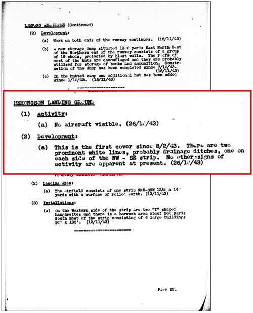
An aerial surveillance of Mae Hong Son airstrip was performed. That it had occurred was noted in Airfield Report No. 16 (November 1943),[16] more than eight months later; but the results are currently unknown because Airfield Reports for February and March, one of which would have contained the information, have not yet been made available by USAF Archives.[16a]
IJA troops first appeared in quantity in the Mae Hong Son area sometime after this date in order to build a road from Chiang Mai, Thailand to Toungoo, Burma. The official Japanese military history of WWII[16ā] records that, in preparation for the IJA invasion of India, a vehicle road was to be established connecting the railhead in Chiang Mai, Thailand, with the road, river, and rail[16α] junction in Toungoo, Burma. That road was to pass through Mae Hong Son, then the border town of Khun Yuam in Thailand, and: . . . Around 01 August 1943,[16ᴂ] the IJA 15th Division's [140th] Engineering Regiment and one Infantry Battalion, as well as the main force of the Independent 23rd Engineering Regiment [were assigned to build the road].[16Ƃ] Amongst local Thais interviewed long after the war, there was a consistent association of the appearance of Japanese soldiers with the construction of a road: When Japanese soldiers came to build the roads . . . I used to see construction crews working on the road . . . supervised by one Japanese engineer. [Only] three or four months after the road was completed, thousands of Japanese soldiers began returning to Khun Yuam.[16β] Two years before the Japanese defeat [ie, 1943], Japanese soldiers came to Ban Mae Surin. I would ask them where they were going. They told me that they would go to China.[16ҍ]
No aircraft were visible at the airstrip at this time, but possible improvements in site drainage were visible. Improvements at the airstrip would be consistent with the arrival of IJA troops building a road from Chiang Mai to Toungoo, Burma --- and improving existing facilities in-between. More interesting is that the site had not been checked since 08 Feb 1943, a lapse of more than eight months: this suggests that the Allies' estimated potential of the airstrip for significant activity was low.[16b]
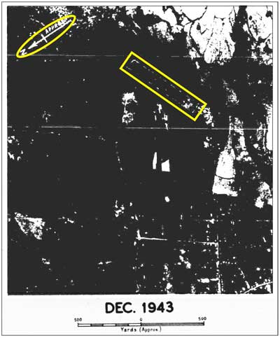
The IJA road project linking Chiang Mai with Toungoo, Burma, via Mae Hong Son, was largely abandoned, because it was seen as impossible to complete in time to support the IJA invasion of India.[16c] December 1943 An Allied intelligence report provides an aerial photo of Mae Hong Son airstrip; key features initially distinguishable are marked with yellow surrounds:[17]
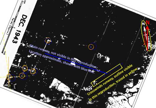
This realignment relies upon locating prominent features on different aerial photo sources and then matching them on overlays (hence the unlabeled small circles and lines). Note that the photo's original north was designated "approx". The quality of the photo is very poor because it is a microfilm copy of a printed publication of unknown quality.
|
16φ.^ , 戦史叢書 : Vol 15: インパール作戦―ビルマの防衛
16.^ Airfield Report No. 16, Nov 1943, p 22 (USAF Archive microfilm reel A8055 p 277). 16a.^ Query sent by email 18:13 17 Jun 2012: no response as of 26 Jun 2012.
16ā.^ (戦史叢書) Sensi Sosho (War History Series). 16α.^ By this time, however, one of the two sets of railroad tracks had been "taken up" per Brown, Atholl Sutherland, Silently into the Midst of Things (Victoria BC: Trafford, 2001), p 40. 16ᴂ.^ This date is generally confirmed by a statement later in the Senshi Sosho text: "The Army Group, on 12 August 1943, gave the order to prepare for the Imphal operation to the 15th Army" (Senshi Sosho v15, p 148). 16Ƃ.^Senshi Sosho v15, p 139. 16β.^ บ้อมูลเส้นทางเดินทัพทหารญี่ปุ่น 16ҍ.^ ibid, Mr Boon-ton Sriwichai (Interviewee No. 8). 16b.^ Airfield Report No. 16, ibid.
16c.^ Senshi Sosho v15, p 179.
17.^ Airfield Report No. 21, Apr 1944, unnumbered page (USAF Archive microfilm reel A8055 p645) (note that, for whatever reason, it took six months for the photo to be published).
18.^ ibid. Realignment based on Google Earth view of the airstrip area plus contents of Airfield Report No. 32, Mar 1945, aerial photo "Mae Hong Son Landing Ground", unnumbered page (USAF Archive microfilm reel A8056 p 53).
|