| N19°16 E97°56 |
Mae Hong Son Airstrip |
Route 1095 |
| Text | Notes |
|
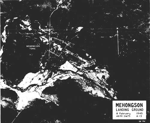
Despite its poor quality, the aerial photo below is particularly useful in that it provides sufficient detail to fairly accurately locate the old airstrip with relation to the new. One error is that the north arrow should be pointing about 10° to the right: it appears to be aligned approximately with the north-south road to the west of the main runway --- in actual fact, that road is on heading 170°-350°. See illustration on page one:[29]
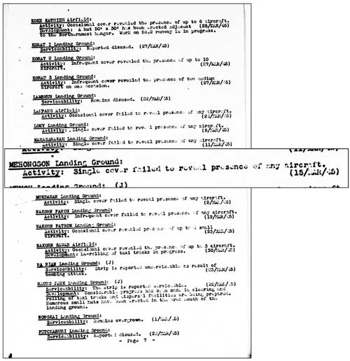
The quality of this photo is very poor because it is a microfilm copy of a printed publication of unknown quality. The flight report below records the single aerial photo coverage of Mae Hong Son and environs by the 21st Photographic Reconnaissance Squadron (21PRS), part of the 14th Air Force headquartered in China. Other coverage obviously exists: 40PRS is credited with having taken the aerial photo above on 06 Feb 1945 per mission no. 5 M 75, but I have found no reports from that unit as yet. 15 March 1945 The March 1945 Airfield Report comments probably evidence Japan's growing inability to replace damaged/destroyed equipment:[30a]
Shores records: 20 March 1945 . . . fighter squadrons of the 2nd Air Commando Group flew to northern Thailand to strafe fields at Chiengmai . . . . Near Chiengmai Capt William C Marshall of the 1st Command Squadron [and flying a P-51] encountered a small single-engined aircraft which he identified as a 'Stinson-type' and shot it down. It was in fact a civilian Fairchild 24 of the Aerial Transport Company of Thailand, which was unfortunate enough to have arrived at exactly the same time as the US fighters.[30b] The narrative appears to have been inaccurate in that ground sources apparently witnessed the same event and one saw the plane crash near Mae Surin (N18°54.77 E97°56.68), 113 km (70 mi) WNW of Chiang Mai, but only 44 km (27 mi) south of Mae Hong Son.[30Ƃ] Chronicled in that downing is the death of a locally famous pilot, a Mr Puai, who had long flown the connection between Chiang Mai and points west --- Mae Hong Son and Mae Sariang.[30β] Another source recalls three more deaths: . . . there was a [Thai] mail plane (for letter delivery from Mae Hong Son to Amphoes Khun Yuam and Mae Sariang). This plane flew three times a month. One day, the mail plane met an [Allied Forces] plane flying in the opposite direction. The pilot wrongly identified the Thai pilot of the mail plane as Japanese and shot the mail plane which caught fire and crashed in the Ban Mae Surin area. Villagers went to the crash site and found four dead bodies: the pilot, Mr Puai [surname unknown]; a pilot assistant [name unknown]; a Japanese soldier in uniform; and the superintendent of Mae Hong Son.[30c]
For record purposes, as of July 2012, good quality World War II era aerial photographs of the Mae Hong Song area have not been found.
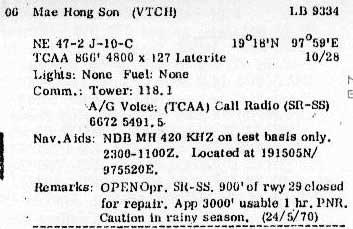
Information in the Air America Air Facilities Data Thailand pamphlet entry on Mae Hong Son airstrip does not mention the cross-winds runway, but is otherwise consistent with earlier observations. It would appear that the crosswinds runway had been abandoned:[30d]
Key items, location and runway headings, generally conform to past and present data on the airport. The terms are defined at Air America Air Facilities Data Thailand legend.
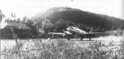
From Chiang Mai University Library website "Lanna past through pictures", is a view of the Mae Hong Son Airport runway in 1974. Taken by Boonserm Satrabhaya, he probably used a telephoto lens and shot from Wat Phra That Doi Keng Mu (N19°18 E97°57.6). Another 1974 photo looks westwards and shows the terminal building plus Doi Keng Mu in the background with the wat visible as two small white triangles near the summit:[31a]
The area is covered by Royal Thai Survey Department Map No. 4547 I, Title: Mae Hong Son: 7017 Series (Mar 1992): information is out-of-date Distribution of this map is severely limited by the Thai government which seems to have a policy of minimizing the availability of government information about border areas. As such, the map is not available to the general public. Coverage of the area by Google Earth, PointAsia, Bing, Flash Earth, etc, is readily available directly on the Internet; plus Garmin, Magellan, Tom‑Tom, etc, PNDs; and smart phone apps, whatever technology ‑‑‑ can be substituted. In almost all cases these alternate sources are more up-to-date, more accurate, larger scale, etc.
Name: Mae Hong Son Airport - VTCH The Thai Flying Club webpage includes an excellent view on the approach path to the airport to illustrate why the airport is "one-way".
|
29.^ Airfield Report No. 32, Mar 1945, aerial photo "Mae Hong Son Landing Ground", unnumbered page (USAF Archive microfilm reel A8056 p 53).
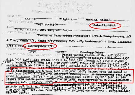
30.^ 21st Photographic Reconnaissance Squadron Report Mission No. 5 MA 39, 17 Feb 1944 (USAF Archive microfilm reel A0878 p0769).
30a.^ Airfield Report No. 32, Mar 1945, aerial photo "Mae Hong Son Landing Ground", unnumbered page (USAF Archive microfilm reel A8056 p 126).
30b.^ Shores, Christopher, Air War for Burma (London: Grub Street, 2005), pp 342‑343. 30Ƃ.^ Information about Japanese Soldiers, Mr Boon-ton Sriwichai (Interviewee No 8). 30β.^ , บุญเสิม สาตราภัย
30c.^ Information about Japanese Soldiers, ibid.
30d.^ Air Facilities Data Thailand 432 (?: Air America?, 1971), p 6. See Key for interpreting page content.
31a.^ Boonserm Satrabhaya, ibid, p 138. Photo included here per his suggestion.
32.^ Thai Flying Club webpage for Mae Hong Son.
|