| N18°10.90 E97°55.84 | Mae Sariang Airstrip (Th: ท่าอากาสยานแม่สะเรียง / Jp: メサリアン滑走路 ) page 2 of 2 |
Route 0108b |
| Text | Notes |
|
Activities during the war 04-30 January 1942 The Kong Bin Noi Phasom (Combined Wing) 80, newly stationed at Chiang Rai,[13] sent Vought Corsairs and Curtiss Hawk IIIs from Squadrons 22 and 41 to scout and bomb the enemy in various locations in Burma and to patrol the skies over Mae Chaem, Mae Sariang, Khun Yuam, and Mae Hong Son.[13a]
Sgt Pilot Victor Bargh, a New Zealander, in Royal Air Force (RAF) 67 Squadron, flew a photo-reconnaissance mission from Mingaladon, over Mae Sariang.[13b] 21-22 January 1942 [RAF 113 Squadron] Blenheims bombed Raheng and Mesarieng on the 21st and 22nd, dropping 6,000 lb of bombs on each target.[14]
The Indian Air Force (IAF) made a surprise strafing attack on Mae Sariang.[14a]
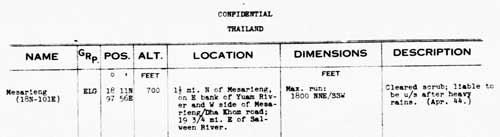
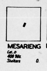
Allied intelligence issued a so-called "airfield miniature" of Mesarieng airstrip:[15] "Cat D"
(Category D) refers to "Fair weather only".
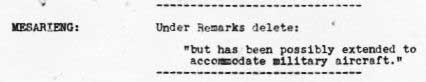
An early amendment to an Allied intelligence report:[16]
Transcription MESARIENG: Under Remarks delete: "but has been possibly extended to accommodate military aircraft." Note: the sheet to which this applies is not available.
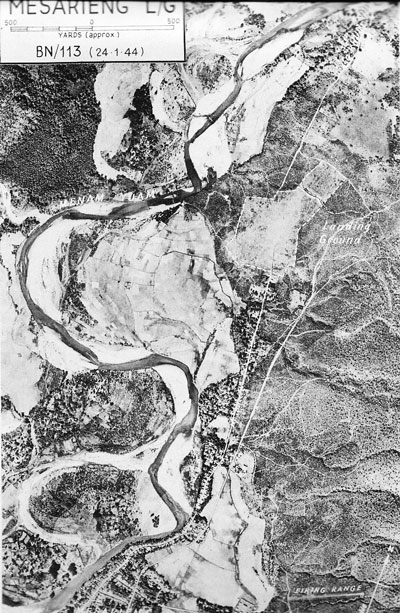
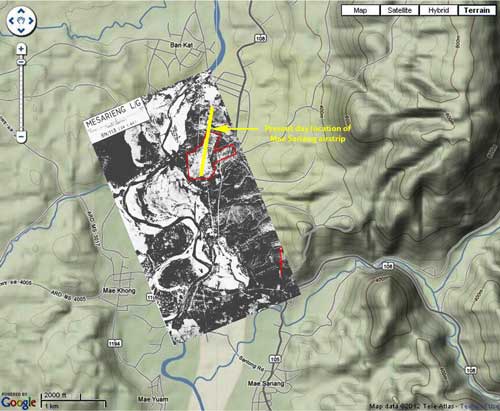
This aerial photo, taken in January, was only published in the April 1944 issue of Airfield Report. While not of raw aerial photo clarlity, this image, scanned by Sakpinit Promthep from the original Airfield Report, is a vast improvement over the version previously used here which was a microfilm copy:[17]
Note that the north arrow in the lower right corner of the photo does not point directly up the page. Placed on a modern map shows its proper orientation and is the basis for the location map on page 1 of this article.[17a]
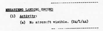
An Allied intelligence report noted no activity:[18]
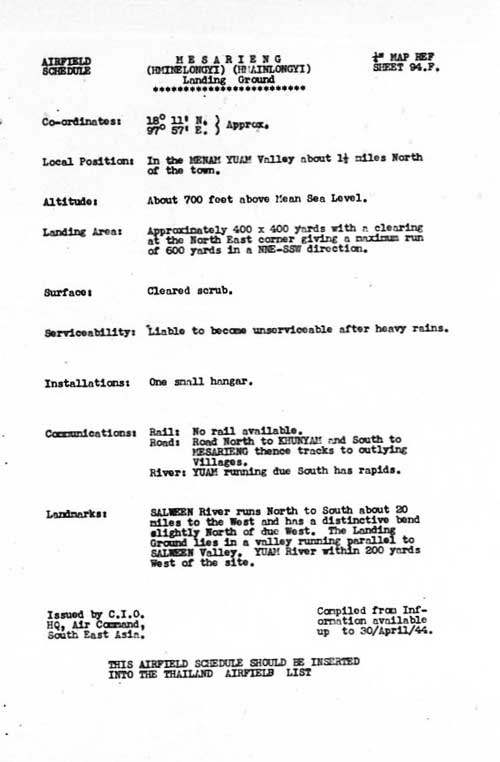
The earliest formal Allied intelligence report currently available:[19]
Transcription: MESARIENG (HMINELONGYI) (HMAINLONGYI) Landing Ground Compiled from information available up to 30 Apr 44.
Transcription: It is interesting to note that the meagre line of landing grounds in close proximity to the Burmese border from Mae Hong Son to Mae Sot, including Khun Yuam and Mae Sariang, have not to date been developed. In view of their difficult lines of communication it is unlikely however, that they would be employed for any purpose other than emergency use so that some form of maintenance work is likely to be the limit of their attention.
The airstrip with some detail was included in an Allied intelligence listing of airports:[20]
Transcription: Name: Mesarieng (N18 E101)
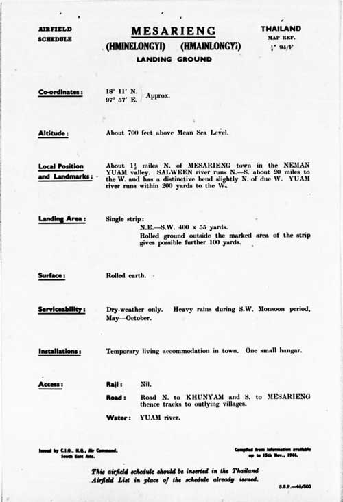
Another Allied intelligence formal report on the Mae Sariang airstrip:[21]
Transcription: MESARIENG (HMINELONGYI) (HMAINLONGYI) Landing Ground
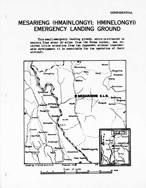
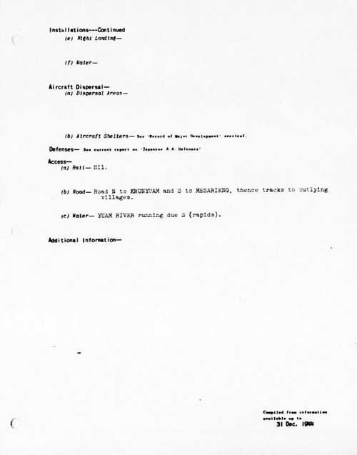
The last formal Allied intelligence report on the Mae Sariang airstrip:[22]
"This small emergency landing ground, which is situated in western Siam about 20 miles from the Burma border, has received little attention from the Japanese; without considerable development it is unsuitable for the operation of their aircraft."
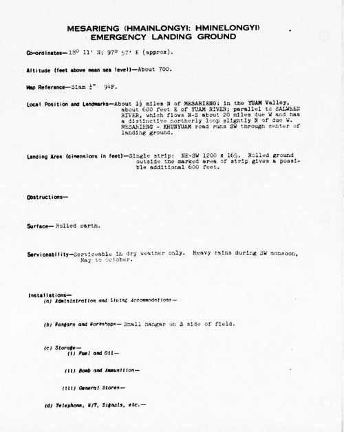
Transcription: MESARIENG (HMAINLONGYI; HMINELONGYI)
According to Mr Porm Sootsukon (a civil servant in Mae Hong Son) around 1235 hours on 05 Mar 1945, a single two-engined Allied Forces plane from the direction of Burma flew over the Mae Sariang governor's official resident and then went on . . . . It was assumed that the intent . . . was just psychological in support of the Free Thai movement.[24]
". . . the fighter squadrons of the 2nd Air Commando Group flew to northern Thailand to strafe fields at Chiengmai and [Phrae][25], which were being used by the Japanese as air staging posts. Near Chiengmai Capt William C Marshall of the 1st Command Squadron encountered a small single-engined aircraft which he identified as a 'Stinson-type' and shot it down. It was in fact a civilian Fairchild 24 of the Aerial Transport Company of Thailand,[25a] which was unfortunate enough to have arrived at exactly the same time as the US fighters."[25b]
The pilot who flew the Norseman regularly from Chiang Mai to Mae Hong Son before the war, was a Mr Puai. Local people called the aircraft "Mr Puai's aircraft". During the war, Mr Puai was shot down by an Allied aircraft while flying to Mae Sariang. The company and local people as well as his family were saddened to lose a good and friendly pilot.[26]
Interviewee No. 8, Mr Boon-ton Sriwichai: After [?] the war, there was a Thai mail plane (for letter delivery from Mae Hong Son to Amphoes Khun Yuam and Mae Sariang). This plane flew three times a month. One day this mail plane encountered British aircraft flying in the opposite direction. The British pilots saw the Thai pilot and mistook him for a Japanese. Later the mail plane encountered 40 – 50 British planes, two of which turned and attacked. The mail plane caught fire and crashed in the Ban Mae Surin area. Villagers went to see the plane crash site and found four dead bodies. They included the pilot, Mr. Pui (surname unknown); a pilot assistant (name unknown); a Japanese soldier in uniform; and the superintendent of Mae Hong Son. The next day, the bodies were ceremonially cremated. The remains of the Japanese soldier were taken to Japan. There were some burnt banknotes (about 10,000 baht), two pistols, and other belongings in the crashed plane which district officers took.[27]
Amendments to Airfield Lists: SIAM: Amendment List No. 1 (1945):[28]
Transcription: MESARIENG L/G: Landing Area: Amend to read: Apparently this item amends the report dated 31 December 1944 here.
. . . [apparently in late 1945] seven planes, guns firing, dropped
Through 15 August 1945 (end of war) For record purposes, as of July 2012, good quality World War II era aerial photographs of the Mae Sariang area have not been found.
View of the condition of the airstrip by a member of the 1977 Japanese team searching for I J A remains: . . . on the eastern side of the "airfield." I say "airfield": it is only a narrow field where the red clay is raked and flattened. All around seems to be a second-growth forest of teak; weeds and bushes are grown out to about one or two meters.[29a]
The movie, Air America, was released in 1990; it had used the airstrip at Mae Sariang in some of its scenes.[29b]
Royal Thai Survey Department Map No. 4545 II, Title: Mae Sariang: 7017 Series (Mar 1992): information is out-of-date
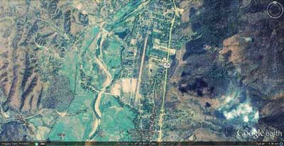
Google Earth view of Mae Sariang airstrip area[30]
Name: Mae Sariang Airport - VTCS4 The Thai Flying Club's two oblique photos of the runway also demonstrate that it was paved sometime between 2003 and 2007.
|
13.^ Young, ibid, p 185. 13a.^บระวัติกองทัพอากาศไทย 13b.^ Frances, Neil, Ketchil (Masterson NZ: Wairarapa Archive, 2005), p 68. [My ref: Aerial N186]. 14.^ Shores, Christopher & Brian Cull, with Yasuho Izawa, Bloody Shambles vol I (London: Grub Street, 2007), p 260 [My ref: BSI:07 260, 21-22 Jan 42]. Also Young, ibid, p 186 [My ref: Aerial N 186]. Corroborated by Pearson, Michael, The Burma Air Campaign 1941-1945 (South Yorkshire: Pen & Sword, 2006), pp 33‑34. 14a.^ Information from The Official History of the RIAF per Jagan Pillarisetti email of 29 Jun 2008 00:11. 15.^ Airfield Report No. 18, Jan 1944, Airfield Miniatures, unnumbered page (USAF Archive microfilm reel A8055 p 422).
16.^ Airfield Report No. 18, Jan 1944, p 37 (USAF Archive microfilm reel A8055 p 476).
17.^ Airfield Report No. 21, Apr 1944, unnumbered page: scan provided by Sakpinit Promthep by email of 10:26 15 Oct 2021 (previous version of lesser quality was from USAF Archive microfilm reel A8055 p 646). [Added 22 Oct 2021]
17a.^ Aerial photo above overlaid on a "Terrain map" from Nations Online Project: Searchable Map and Satellite View of Thailand using Google Earth Data (accessed 20 May 2012). Matching and annotations by author using Microsoft Publisher.
18.^ Airfield Report No. 19, Feb 1944, p 24 (USAF Archive microfilm reel A8055 p 524).
19.^ Airfield Report No. 21, Apr 1944, no page number
19a.^ ibid, p 4, "Review of Airfield Development in Thailand", (USAF Archive microfilm reel A8055 p 618).
20.^ Provisional Airfield List, Report No. 3, 25 Jul 1944, p 63 (USAF Archive microfilm reel A1284 p 1413).
21.^ Airfield Report No. 28, Nov 1944, unnumbered page (USAF Archive microfilm reel A8055 p 1080).
22.^ Siam (Thailand) List of Airfields and Seaplane Stations (Washington: Ass't Chief of Air Staff, Intelligence, 1945), unnumbered page
23.^ ibid, unnumbered pages (USAF Archive microfilm reel A1285 pp 1242, 1243).
24.^รายงาน การ สําร จอขุดค้น - 25.^ Shore identified Phroe: that name does not appear on Thai maps. Similar in name in the area were Phrao, Phayao, and Phrae. Only the last had an air facility (N18°08 E100°10), 60 km ESE of Lampang and shown on US Army Series L509, NE 47-7 "Lampang". 25a.^ "Stinson-type" aircraft: the Stinson SR-series was popular before the war per Wikipedia's Stinson Reliant, but that reference does not list any models in Thailand. Mentioned in a following version: The Noorduyn Norseman. ". . . it looked surprisingly like the Stinson SR 10." per RCGroups.com's Noorduyn U-64 Norseman. However, "Until 1940, the Noorduyn company had sold only 17 aircraft in total, primarily to commercial operators in Canada's north and to the Royal Canadian Mounted Police." per Wikipedia's Noorduyn Norseman. On the other hand, Thai Aviation Net's Thai Civil Register and Royal Thai Air Force listing record no Norseman or Stinson models registered before the war; but the civil register does record a Fairchild 24 exported to Thailand 04 Oct 1940 (that particular aircraft survived at least until 1955) and its Air Accidents list records a Thai Air Force Fairchild 24 shot down in Mar 1945 by a USAAF P-51. It would appear that the aircraft could only have been a Fairchild 24 as Shores asserts. 25b.^ Quoted from Shores, Christopher, Air War for Burma ["The Third . . . Volume of the Bloody Shambles Series"] (London: Grub Street, 2005), p 342. 26.^ บุญเสิม สาตราภัย 27.^ เชิดชาย ชมธวัช, บ้อมูลเส้นทางเดินทัพทห This is the only version to mention the crash site as Mae Surin. There are other stories about a crashsite there. See Mae Surin. 28.^ Airfield Report No. 33, Apr 1945, p 11 (USAF Archive microfilm reel A8056 p 174). 29.^ Report on Archaeological Research, p 109 [My ref: CMMR 109]. 29a.^ Journal, p 455. 29b.^ Thai Flying Club: 30.^ Google Earth view of Mae Sariang airstrip area, image data dated 03 Apr 2003; accessed 30 Apr 2012. 31.^ Thai Flying Club: ibid.
|
.jpg)