Japan in Northwest Thailand during World War II
| N18°21.5 E99°24.4[1] |
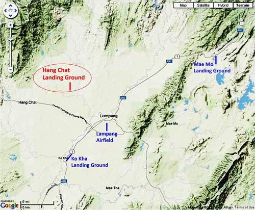
Hang Chat[1a] Landing Ground (Th: ห้างฉัตรท่าอากาศยาน / Jp: ハンチャツ滑走路) Lampang Province Page 1 of 3 |
near Hang Chat RR Station on Northern Route Sta 654.85 [2] |
| Text | Notes | |||||||||||||||||
|
Hang Chat: Summary Hang Chat Landing Ground was the westerly air facility satellite to the Lampang Airfield Group of the Imperial Japanese Army Air Force (IJAAF). The site's two approximately parallel north-south runways were located about 12 km by air northwest of Lampang Railway Station (the reference point used by Allied intelligence during WW2), and about 14 km by air from the Lampang runway. Constructed by the Japanese in 1944-1945, no aircraft was ever observed there. After the war, the runways quickly melted back into their rice paddy heritage and are invisible today.
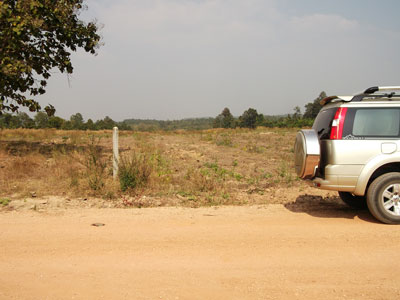
On their arrival, the Japanese first hired local Thais to build huts for them. They located the huts in wooded areas isolated from existing Thai villages. The huts were wood framed, roofed with canvas, with floors of milled wood (they were more substantial than the huts built in Khun Yuam, which had raised floors of split bamboo). The Thai laborers also dug water wells. She did not help in building the huts; but knows that five of them were located less than a hundred meters north of her present house in a wooded area so thick with undergrowth that even her grandson was unwilling to venture in. While the huts are long gone, there is still a water well in the old hut area (Thais feel it might bring bad luck to fill an abandoned well hole (of course, for someone to fall into such a well really would be bad luck)). After the huts were completed, the Japanese recruited many Thais from a wide area to construct the runways and associated facilities. Maeson worked on the latter, supervising the digging of bunkers. They were simple 2 x 2 x 2 meter holes with neither cover nor lining of concrete or wood: earth in the area seems to be largely a very soft laterite rock which would have held its shape. She could not give a count of what she built; but there were many units. Two or three Thais were assigned to digging each one. Runway construction started with the removal of many trees of 40-60 cm diameter. They were sawn down by hand and then dragged to the side with Japanese military vehicles. Stumps were dug up and then hauled out of the way in the same manner (occasionally stubborn stumps were burned first). Neither water buffalo or elephants were used for this heavy work (they simply were not available). The cut trees were not used by the Japanese; Thais were welcome to saw them up and remove them to use them elsewhere, but few did. The soil used to fill stump holes apparently packed easily: Maeson was not aware of any effort to compact the fill, or to "roll" the dirt strips (Allied intel had reported the latter as maintenance). Gravel was not brought in to "metal" the surface.[2a1a] Even with this simplified approach, the project required a large number of laborers working for the better part of a year; runway construction was not Maeson's area of work, so she had no information on crew-size or number of crews, nor how long it took to build just the runways. However, overall, she remembers project construction completed in one year with work continuing through the rainy season. Laborers were hired at four baht for an eight-hour day, and supervisors at eight baht (or perhaps the units were sitang (one-one hundredth of a baht)). They were paid in coin by the Japanese, not in Japanese-printed scrip by the Thai government, as occurred on the Pai-Burma Road at about the same time. Japanese soldiers did not work alongside the Thais as they did on the Pai-Burma Road, but rather maintained a supervisory role. Thais were expected to bring their own tools --- generally Thai hoes, occasionally saws. At the site, the Japanese had five vehicles, probably diesel-engined military trucks, fueled by a tanker truck that appeared periodically. In the succeeding two years, the Japanese continued living in the huts; it is assumed that they acted as security. In those two years, she cooked three meals a day for the soldiers in the huts just north of her current house. The soldiers bought vegetables and meat at the Hang Chat market; for meat, they preferred butchered chicken. The market was several kilometers away and the soldiers carried the goods back themselves: neither they nor Thais in the area at that time had bicycles. While the Japanese were friendly and kind, they maintained their distance --- she never saw Thais eating with them (which was a common occurrence on the Pai-Burma Road project). This might have been in part because communication was never more than rudimentary: Thais and Japanese learned only enough of each other's language just to get by. She recalls no aircraft ever having used the airstrips; nor does she recall the airstrips ever having been bombed, such as happened at Mae Mo.[2a2] At the end of the war, the soldiers simply left. They gave no farewell gifts as some did at Khun Yuam; she feels that the Japanese and the local Thais felt no camaraderie so gifts were neither expected nor relevant.[2a3] The runways quickly became overgrown and eventually disappeared as they were (re)cleared as adjacent areas were cleared for farming. Maeson's daughter and grandson directed me to what they believed were the locations of the airstrips. There is, in fact, possible evidence of a runway at one site. As viewed from the ground:[2a4]
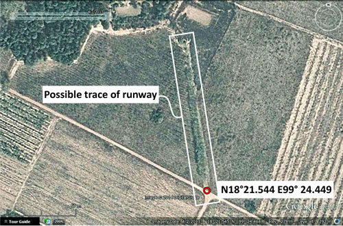
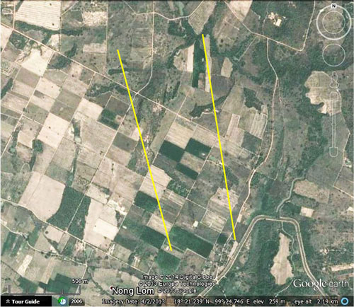
The evidence lies in the vague set of lines in the soil going off into the distance at about a 30° angle directly off the left rear quarter panel of the car. The lines take on much greater significance when viewed from above via Google Earth:[2a5]
To be fair, however, what is so prominent in this aerial view is apparently a treeline which was removed before my visit (my photo on the ground shows no treeline, just lines in the soil). Google Earth's view is dated 04 Feb 2013; the apparent line's visibility must be rechecked when Google Earth updates coverage of this area. Further, older aerial photos of this area, available via Google Earth, do not show the apparent line nearly as prominently as this. On the other hand, for record purposes, with the assumption that the line is valid, the approximate 144 m segment of what would be part of the easterly runway is extended below to 1750 yards (1600 m) --- the length of the original runway --- and the westerly runway is also roughed in, in similar fashion:[2a6]
This view is compared with the Allied intel record here.
|
These pages were composed to be best viewed with Google Chrome. See Key for interpreting page content. Revision list. See bottom of Text column on this page. Bibliography supports notes. 1.^ Source: USAAF data fitted to Google Earth. 1a.^ During WWII: "Hangsat". Earliest postwar maps found to date use "Hang Chat". Note: not listed in Air America's Air Facilities Data Thailand 432, 1971. 2.^ Whyte, BR, The Railway Atlas of Thailand, Laos, and Cambodia (Bangkok: White Lotus, 2010), p 28. 2a.^ "Terrain" map from Nations Online Project: Searchable Map and Satellite View of Thailand using Google Earth Data. Annotation by author using Microsoft Publisher.
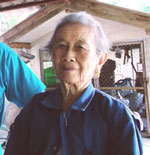
2a1.^ Per interviews on 22 and 29 Jan 2014 with แม่สนท์ วงศ์ต่อม, 54 ม. 2 บ้านล้อง ต. หนองหล่ม อ. ห้างฉัตร ลำปาง at her house (N18° 21.436' E99° 23.269'). Maeson Wongtom, 54 Moo 2 Ban Lhong, Tambon Nong Lom, Amphoe Hang Chat, Changwat Lampang. At the first meeting, her daughter, นัำฟน วงศ์ต่อม, Numfon Wongtom, acted as translator; for the second meeting, Jiraporn Jacqmin translated. Maeson knows of only one other person in the area who is still alive and worked on the airstrips: he's now 90 and unfortunately senile. Photo: extract from DSCF1641.jpg of 22 Jan 2014, taken by Numfon Wongtom. Contrasts are here described between Hang Chat and Khun Yuam. The comparison is fair only if it is realized that circumstances at the two were very different: The Pai-Burma Road work was pursued in late 1943 under extreme presssure from the Japanese Army's high command, so the soldiers joined in with the manual labor in what turned out to be a futile effort to complete the road in time to support the IJA's invasion of India. Many, many huts were constructed at Khun Yuam to house troops retreating from the IJA's disastrous effort to invade India in 1944-1945. Time was at a premium, as were materials and able bodied troops, and innovation was key to the IJA having put up so many shelters so quickly at Khun Yuam. Because of the desperate physical condition of many of the retreating IJA troops, who were suffering from wounds, amputations, gangrene, starvation, malaria, etc, many Thais provided substantial assistance to their downfallen allies. This spirit of charity resulted in a camaraderie between Thais and Japanese that neve developed at Hang Chat. 2a1a.^ The term, "metaling" is described here.
2a2.^ Oddly, Maeson did say that she had seen a helicopter use the strip. In the Axis realm, the Germans had a limited number of such aircraft, however the Japanese had none. Interestingly, the Allies did use helicopters primarily for rescue in Alaska and in Burma. but the appearance of one in Lampang is unlikely. (Wikipedia: helicopter) 2a3.^ Maeson noted also that she never saw any Thai military at the site. 2a4.^ DSCF1632.jpg, 22 Jan 2014, by author.
2a5.^ Google Earth view of segment of possible runway site; viewed 31 Jan 2014. Annotations by author using Microsoft Publisher.
2a6.^ Google Earth view of possible runway sites; viewed 02 Feb 2014. Annotations by author using Microsoft Publisher.
|
|||||||||||||||||