Lanna-ww2

Northwest Thailand during World War II

N18°11.90
E99°24.67
Ko Kha Landing Ground (Th: เกาะคาท่าอากาศยาน/ Jp: コカ滑走路)
Lampang Province
Page 2 of 3
Route 0001
Sta 690~


Text Notes


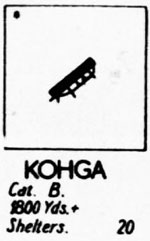
January 1944: This was the first month that Allied intelligence claimed that the Ko Kha airstrip was constructed by the IJA (the black dot, actually an asterisk, at the top left of the miniature so indicated):[3]

KK miniature showing IJA origin

This assertion as to origin conflicts with RTAF official history. See entry for 22 December 1941.


09 January 1944
: Aerial photo reconnaissance of Ko Kha had been ongoing by this date, as evidenced by the aerial photo dated 30 April 1943. but text reports of such prior to this date are not yet available from archival sources. Here Ko Kha AD (airdrome) was photographed per order:

Ko Kha aerial 09 Jan 1944[3å]


It is not clear what the following amendment applies to --- no formal report on the Ko Kha Landing Ground (such as the report on 30 April 1944 below) has been found predating this amendment, to which it might apply.

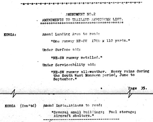
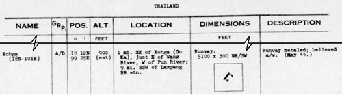
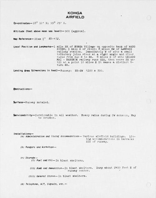
Regardless, key information is that the runway had apparently been "metaled",[3å1] making it all-weather, in contrast to Lampang Airfield which was not "metaled", ie, all-weather. Potential reasons for this seeming oddity:

1. Both towns were located on the main north-south highway for
    which gravel sources should had been already developed; but
    the source for Ko Kha might have been more accessible than
    that at Lampang.
2. The political (?) force which located Thailand's first sugar mill in
    Ko Kha continued its influence, even though Wing 80 had been
    relocated to Lampang.
3. Ko Kha might have been militarily more important than Lampang:
    the concept of the Lampang Airfield Group could have been purely
    an Allied Intel construct which was in error.

[3a]
Amendment to KK status


24 January 1944: Recall that the status included at the end of 1943 (previous page) included a comment, "No aircraft visible (24/1/44)".


07 February 1944: And a month later (after 09 January), another photo report:

Ko Kha aerial 07 Feb 1944[4]


13 February 1944: Construction work continued, with no aircraft in sight:

[4a]
KK status 13 Feb 1944


24 February 1944
: Ko Kha was shrouded in clouds:

440224 photo report[4b]


26 February 1944
: Another photo report about three weeks later (after 07 February): possibly because haze would not allow his photographing all his objectives, the pilot made an extensive "tour" of the Lampang area, which was apparently clear of haze. It included two photo runs on Ko Kha, presumably to use up his excess of film in the most productive manner. But the quality of the resulting photographs over Ko Kha cannot be judged since they are not currently available:

Ko Kha aerial 26 Feb 1944[5]

This was the last photo report from 21 PRS for seven months: the next being on 22 September.


01 March 1944: While the following diagram is comparatively crude (more of a schematic than a map sketch), it does offer useful information:

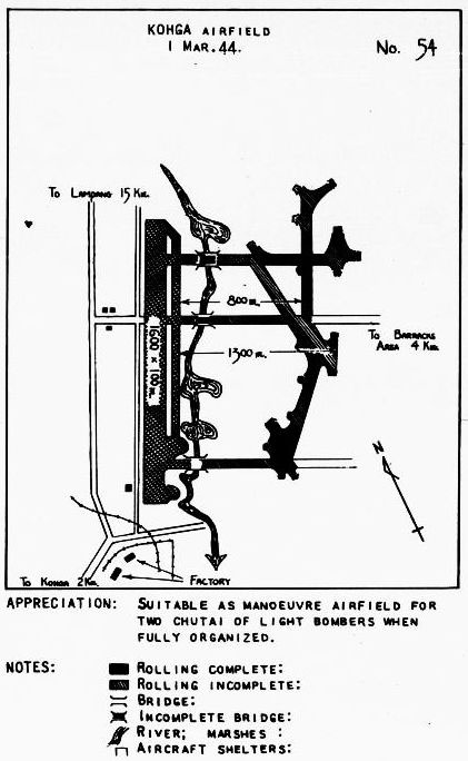
• The eventual capacity of the facility was estimated at two
   chutai of light bombers (a chutai, or squadron, of aircraft,
   in the IJAAF, typically numbering nine[5å]).
• There was extensive development to the east of the runway,
   mainly an extensive taxiway / taxi-track system to access
   support facilities --- in place or planned.
• It further fuels questions about the revised length of the
   runway by labeling it 1600 yards, not 1700 or 1800 yards,
   as in other versions.
• The facility is described as an airfield rather than a landing
   ground.

The diagram is also frustrating because, while it is supposedly coded per the "Notes" following, the coding is unclear in this reproduction; while symbols for aircraft shelters are listed, none appear in the actual diagram.

Crude drawing of KK[5a]


April 1944: In the following excerpts from an analysis titled "Review of Airfield Development in Thailand", is a mention of Ko Kha; equally important is the Allied intelligence analysis of the IJA position in Burma and Thailand:

[5b]
Allied intel analysis of IJA strategy

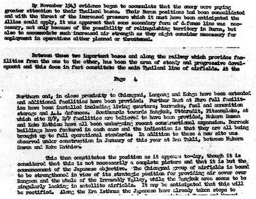
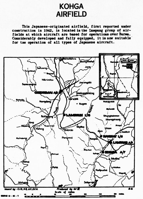
Transcription of relevant parts, with emphasis mine:

By November 1943 evidence began to accumulate that the enemy were paying greater attention to their Thailand bases. Their Burma positions had been consolidated and with the threat of the increased pressure which it must have been anticipated the Allies could apply, it was apparent that some secondary form of defence line was necessary, not only because of the possibility of relinquishing territory in Burma, but also to accommodate such increased air strength as they might consider necessary for employment in operations either planned or threatened. . . .

. . . Between these two important bases [of Chiang Mai and Bangkok] and along the railway which provides facilities from the one to the other, has been the area of steady and progressive development and this does in fact constitute the main Thailand line of airfields. At the northern end, in close proximity to [Chiang Mai], Lampang and Ko Kha have been extended and additional facilities have been provided. . . .

This then constitutes the position as it appears today, though it is considered that this is not necessarily a complete picture and that it is but the commencement of the Japanese objective. The [Chiang Mai] group of airfields is bound to be strengthened in view of its strategic position for providing air cover over Rangoon and the whole of the Irrawaddy Valley . . . .

Note that this review was prepared before the IJA's not defensive effort, but rather its offensive began to invade India, for which troop and equipment movement was already well underway when this review was prepared. The invasion turned into a rout, and Japan did indeed find itself "relinquishing territory in Burma".

While evaluating Thai airfield improvements as possibly to "accommodate . . . increased air strength", Allied intelligence, while noting the many aircraft at Bangkok at this time, failed to consider the consistent lack of aircraft reported on airfields in the northwest of Thailand: for example, despite 32 aircraft shelters at Ko Kha, no aircraft had ever sighted there.

An important concept first appeared here, "the main Thailand line of airfields". It would first be graphically presented in October 1944's Airfield Report.[5b1]


24 April 1944: Routine aerial photos were taken of Ko Kha:

[5b2]
KK 24 Apr 1944


25 April 1944: This report continued an unbroken sequence of observations that no aircraft were seen using the facility:

[5c]
KK observatns 25 Apr 1944


30 April 1944: Here a more comprehensive report consolidated available information, without much new information actually added:

[5d]
KK formal rpt 30 Apr 1944


May 1944
: From a list of all enemy airfields in Southeast Asia, this detail:

[5d1]
KK charted status


TRANSCRIPT:

NAME Kohga [Ko Kha] (18N-101E)
GRP
[facility type]
A/D [airdrome, or airfield with all weather runway or complete facilities or both]
POS ° ' [position] 18 12N 99 25E
ALT FEET [altitude] 900 (est) [estimated]
LOCATION 1 mi SE of Kohga (Go Ka), just E of Wang River, W of Pun River; 9 mi SSW of Lampang RR sta
DIMENSIONS FEET Runway: 5100 x 300 NE/SW
DESCRIPTION Runway metaled; believed a/w [all weather] (May 44)


No asterisk preceded the name, Kohga, which meant that the airfield was not "constructed by the enemy", this per the list's glossary; which, of course, contradicts information first presented in January 1944.

The airfield is described as located "one mile southeast of Ko Kha"; elsewhere it is northeast.

The airfield is described as located "west of Pun River"; the waterway does not appear on any map; however, the Huai Het Lom, a stream, flows south through Ban Mae Pun, about 500 m directly east of the south end of Ko Kha airstrip.[5d2]


06 May 1944: On the ground, development / improvement efforts had ceased (and no aircraft sighted):

KK activity rpt 06 May 1944[5e]


29 May 1944
: Aerial photos were taken of Ko Kha:

[5e1]
KK aerial 29 May 1944


04 September 1944: This report continued the unbroken sequence of observations that no aircraft were using the facility:

[5g]
KK status 04 Sep 1944


Minor construction started up again with the appearance of a new ammunition dump 700+ m east of the runway. This would have been located off the east taxiway (see 01 Mar 1944 "map")


22 September 1944: This was the first aerial photo report from 21PRS since 29 May, and orders would continue in October and November:

Ko Kha aerial 22 Sep 1944[6]


22 October 1944
: Again, Allied Intel over flights observed no aircraft were using the facility:

[6a]
KK status 22 Oct 1944


25 October 1944
: And a follow-up aerial photo report a month later (after 22 September):

Ko Kha aerial 25 Oct 1944[7]


02 November 1944
: The first of three photo requests in November --- but this one failed because of overcast conditions:

Ko Kha 02 Nov 1944[8]


11 November 1944
: The second of three photo requests in November --- this one successful:

Ko Kha 11 Nov 1944[9]


15 November 1944:
This was a more formal report, printed rather than typed as on 30 April (above). The new format was consistent with that for Lampang of the same date.

Local position below corrects the relationship of the airstrip to Ko Kha village --- "NE", northeast, not "northwest" as previously stated.

[9a]
KK formal rpt 15 Nov 1944

The "small tributary" mentioned in the "Local Position and Landmarks" would have been the Pun named in the May 1944 report.


27 November 1944: The third of three photo requests in November, this one also successful:

Ko Kha 27 Nov 1944[10]


December 1944: Note that this is the first formal text statement by Allied intel that the Ko Kha airstrip is Japanese in origin; "miniature" depictions of the airstrip with that information began in January 1944 (again, this would appear to be in error, see 22 December 1941 note on previous page). This report is only the second to title the facility an "airfield":

[10a]
Formal map sketch Dec 1944


13 December 1944: A single overflight found no aircraft.

[10b]
KK activity rpt 13 Dec 1944


31 December 1944: Information about Ko Kha as put out via Washington. The term "blast shelter" is also introduced here to describe structures for fuel, oil, ammunition, and even general storage.

[10c]
KK semi-formal rpt Dec 1944

[10d]
KK semi-formal rpt Dec 1944 cont'd

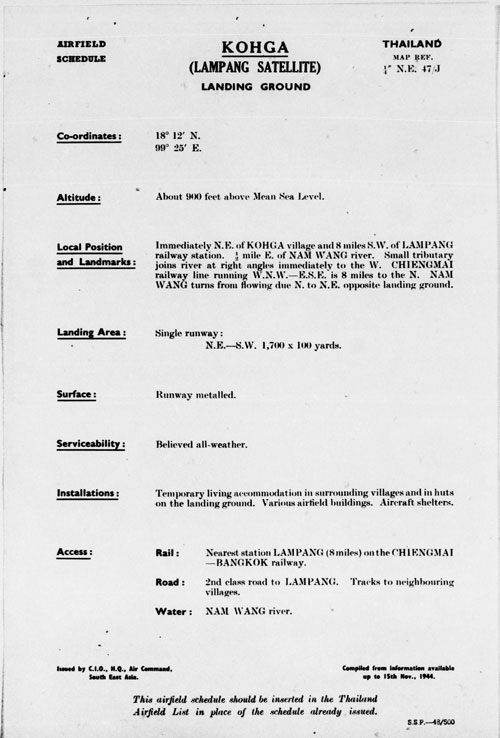
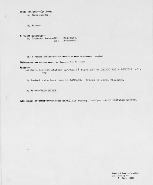
TRANSCRIPT:

Coordinates --- 18°12'N; 99°25'E
Altitude (feet above mean sea level) --- 900 (approximately)
Map Reference --- Siam 1/4" NE-47J
Local Position and Landmarks --- 1 mile northeast of Ko Kha Village on opposite bank of Wang River; 1/2 mile east of river; 8 miles southwest of Lampang railway station. Immediately west of site a small tributary joins river at a right angle and river turns from due north to northeast. 8 miles north of site Chiang Mai - Bangkok railway runs ESE, then veers southeast until at a point 10 miles east it makes a distinct V-turn northeast.
Landing Area (dimensions in feet) --- Runway: NE-SW 5100 x 300.
Obstructions ---
Surface --- Runway metaled.
Serviceability --- Serviceable in all weather. Heavy rains during SW monsoon, May to October.
Installations ---
     (a) Administration and Living Accommodations --- Various
            airfield buildings. Living accommodations in barracks ESE
            of runway.
     (b) Hangars and Workshops ---
     (c) Storage ---
          (i) Fuel and Oil --- In blast shelters.
          (ii) Bomb and Ammunition --- In blast shelters. Dump
                about 2400 feet east of runway center.
          (iii) General Stores --- In blast shelters.
     (d) Telephone, W/T, Signals, etc ---
     (e) Night Landing ---
     (f) Water ---
Aircraft Dispersal ---
     (a) Dispersal Areas ---
            NE: Moderate.
            SE: Moderate.
     (b) Aircraft Shelters: --- See "Record of Major Development"
            overleaf
.
Defenses --- See current report on "Japanese AA Defenses"
Access ---
     (a) Rail --- Nearest station Lampang (8 miles northeast)
                      on main Chiang Mai-Bangkok railway.
     (b) Road --- First-class road to Lampang. Tracks to local
                      villages.
     (c) Water --- Wang River
Additional Information ---


3.^ Airfield Report No. 18 (Jan 1944), unnumbered page (USAF Archive microfilm reel A8055 p0432).


3å.^ 21st Photographic Reconnaissance Squadron (hereafter 21PRS) Report Mission No. 13-4A, 09 Jan 1944 (USAF Archive microfilm reel A0878 p0197).

AD might also mean an all‑weather runway, or a complete facility.


3å1.^ "Metaled" in WW2 time probably meant gravel covered.

From 1951, Brown, et al, Geologic Reconnaissance of the Mineral Deposits of Thailand (Washington: USGPO, 1951), under the heading "Road Metal" (p 139): ". . . 80 percent of the road metal used in Thailand is limestone. . . . Drilling and breaking is usually done by hand . . . there are many small quarries along the highways of Thailand."

Wikipedia's Road surface explains further:
' "metalling" . . . originally referred to the process of creating a gravel roadway.'

Only after the war, the term evolved: "Road metal" later became the name of stone chippings mixed with tar to form the road surfacing material, tarmac.' And a bit of trivia, regarding the term, tarmac, Wikipedia's Airport apron-Tarmac notes: ". . . the general public . . . refer to the apron at airports as "the tarmac" despite the fact that most of these areas are often paved with concrete not tarmac."

3a.^ Airport Report No. 18 (Jan 1944), "Part II - Amendments to Airfield Lists", page 35
(USAF Archive microfilm reel A8055 p 0474).


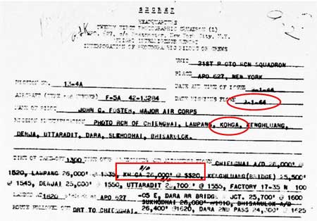
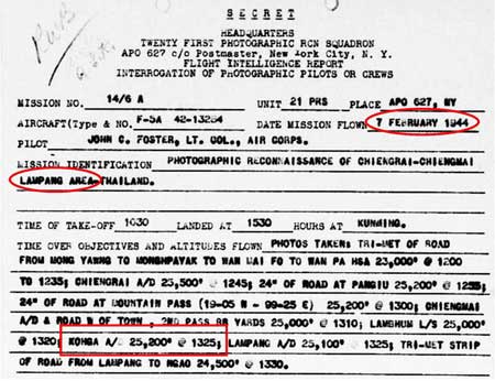
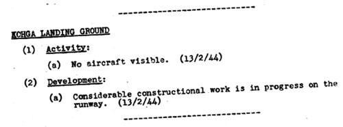
4.^ 21PRS Report Mission No. 14/6 A, 07 Feb 1944
(USAF Archive microfilm reel A0878 p0155).


4a.^ Airport Report No. 19 (Feb 1944), "Record of Airfield Activity and Development", page 23 (USAF Archive microfilm reel A8055 p 0523).


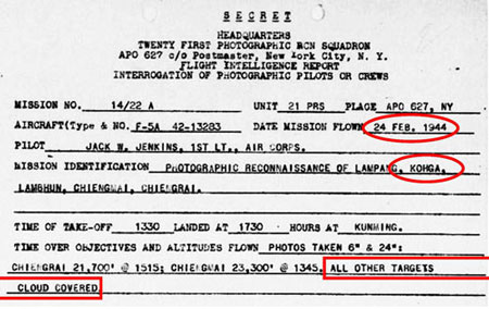
4b.^ 21PRS Report Mission No. 14/22 A, 24 Feb 1944
(USAF Archive microfilm reel A0878 p0122).


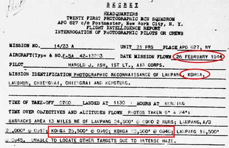
5.^ 21PRS Report Mission No. 14/23 A, 26 Feb 1944
(USAF Archive microfilm reel A0878 p0118).


5å.^ "Unit Structure of IJA Air Force" in Mark's Index: Japanese Aviation.


5a.^ Plans of Airfields in French Indochina and Siam (? South-East Asia Translation and Interrogation Center, 30 Nov 1944), "Order of Battle", unnumbered page (USAF Archive microfilm reel A8023 p 0438).

The crudity of the sketch suggests that the source had been on-the-ground which would be in keeping with the document publisher, ". . . Interrogation Center", rather than aerial photography.


5b.^ Airport Report No. 21 (Apr 1944), "Review of Airfield Development in Thailand", pp 4, 5
(USAF Archive microfilm reel A8055 pp 0680, 0688).


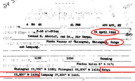
5b1.^ Airport Report No. 27 (Oct 1944), "Comments on Current Airfield Development", following p ii (USAF Archive microfilm reel A8055 pp 0999- 1002). See below.

What was meant by the
"[Chiang Mai] group of Airfields" is not clear. Possibly reference to the Lampang group was intended.

5b2.^ 21PRS Report Mission No. 4 MA 62, 24 Apr 1944
(USAF Archive microfilm reel A0878 p0053).


5c.^ Airport Report No. 21 (Apr 1944), "Record of Airfield Activity and Development", page XVII (USAF Archive microfilm reel A8055 p 0713).


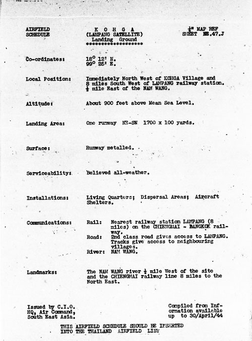
5d.^ Airport Report No. 21 (Apr 1944), unnumbered page (USAF Archive microfilm reel A8055 p 0666).


5d1.^ Provisional Airfield List: Southeast Asia (Washington: Office of Assistant Chief of Air Staff, Intelligence, 25 Jul 1944), page 61 (USAF Archive microfilm reel A1284 p 1411).

Applicable glossary is on page 1 of the publication (USAF Archive microfilm reel A1284 p 1350).

The "miniature" displayed under DIMENSIONS, with its peculiar "tails" cannot be matched with any that were presented in regular issues of Airfield Report.


5d2.^ Royal Thai Survey Department 4845 II, L7017, dated 1992.


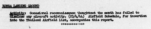
5e.^ Airport Report No. 22 (May 1944), "Record of Airfield Activity and Development", page 14 (USAF Archive microfilm reel A8055 p 0752).


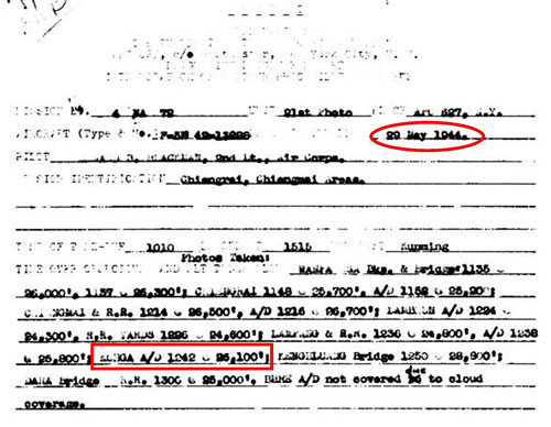
5e1.^ 21PRS Report Mission No. 4 MA 72, 29 May 1944
(USAF Archive microfilm reel A0878 p0010).


5f. (deleted).


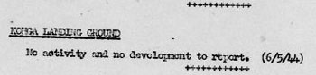
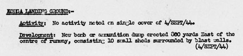
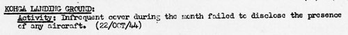
5g.^ Airport Report No. 26 (Sep 1944), "Record of Airfield Activity and Development", page 10 (USAF Archive microfilm reel A8055 p 0988).


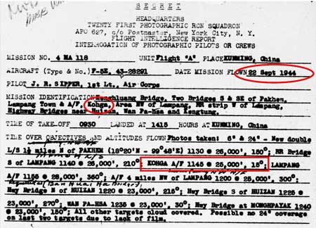
6.^ 21PRS Report Mission No. 4 MA 118, 22 Sep 1944
(USAF Archive microfilm reel A0878 p0476).

Or more correctly, this was the first aerial photo order to 21PRS since February. There is ample evidence in the form of occasional photos with credits that other PRSs (Photographic Reconnaissance Squadrons) were operating in the area; but no records have been released. And conversely, no photos have been found to date credited to 21PRS.


6a.^ Airport Report No. 27 (Oct 1944), "Record of Airfield Activity and Development", page 9
(USAF Archive microfilm reel A8055 p 1019).


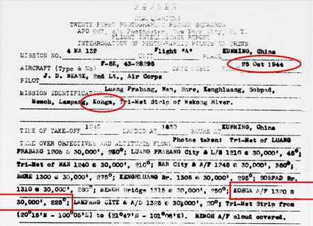
7.^ 21PRS Report Mission No. 4 MA 132, 25 Oct 1944
(USAF Archive microfilm reel A0878 p0551).


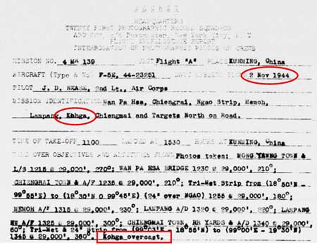
8.^ 21PRS Report Mission No. 4 MA 139, 02 Nov1944
(USAF Archive microfilm reel A0878 p0568).


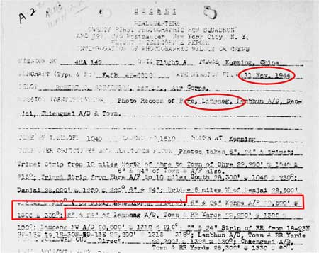
9.^ 21PRS Report Mission No. 4 MA 140, 11 Nov 1944
(USAF Archive microfilm reel A0878 p0586).


9a.^ Airport Report No. 28 (Nov 1944), unnumbered page (USAF Archive microfilm reel A8055 p 1085).


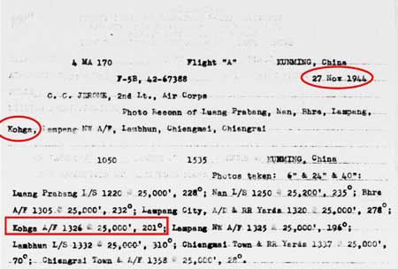
10.^ 21PRS Report Mission No. 4 MA 170, 27 Nov 1944
(USAF Archive microfilm reel A0878 p0769).


10a.^ Siam (Thailand) List of Airfields and Seaplane Stations (Washington: Office of Assistant Chief of Air Staff, Intelligence, 1945), unnumbered page
(USAF Archive microfilm reel A1285 p 1189).

Previous reports have inconsistently referred to Ko Kha as an LG / Landing Ground, AD / Airdrome, and AF / Airfield --- each of which has a different meaning.


10b.^ Airport Report No. 29 (Dec 1944), "Record of Airfield Activity and Development", page 7
(USAF Archive microfilm reel A8055 p 1181).


10c.^ Siam (Thailand) List of Airfields and Seaplane Stations (Washington: Office of Assistant Chief of Air Staff, Intelligence, 1945), unnumbered page
(USAF Archive microfilm reel A1285 p 1190).

Data reflected information available up to 31 Dec 1944.


10d.^ ibid. (USAF Archive microfilm reel A1285 p 1191).