| N18°17 E99°28 |
Lampang Airport (Th: ลำปาง ลำพูน / Jp: ランパーン 滑走路 ) page 5 of 7 |
Route 0001 Station 00c |
| Text | Notes | ||||||
|
There were no reports in the US Army Air Forces in World War II Combat Chronology 1941-1945 of any action involving Lampang during 1945.[46x] Young explained: Although Allied air raids continued into December, with fighters and heavy bombers flying twelve missions, there were no further encounters with the Thai Air Force. The lack of air activity was partly intentional; ostensibly a firm ally of Japan, the Thai Air Force now actively supported the Thai underground against the Japanese. For the next nine months, until Japan's surrender in August 1945, the air force led a double life.[46y] Nonetheless, Young records further, in 1945, Allied air attacks: ". . . continued on the Bangkok-Chiang Mai rail line . . . . Allied bombing raids into Thailand took place every few days as the RAF and the USAAF continued to knock out key rail bridges and damage marshaling yards."[46z] January 1945 Japanese Monograph No 177 in "Outline of 39th Army's Operational Plan - early 1945": The 4th Division . . . will be stationed in the Lampang sector and an element in the Chiangmai sector to secure strategic areas in northern Thailand, and to prevent the invaison of northern Thailand by the Chungking Army and the British Indian Army.[46z1] Conforming to this order was not possible until the 4th Division had completed its move from Sumatra in June 1945. Supplementary orders issued 10 June 1945 clarified. |
46x.^ Carter, KC and R Mueller, compilers, Combat Chronology 1941-1945: US Army Air Forces in World War II (Washington: Center for Air Force History, 1991)
46y.^ Young, ibid, pp 205-206. (emphasis added).
46z.^ Young, ibid, p 211.
46z1.^ Young, ibid, p 211. |
||||||
|
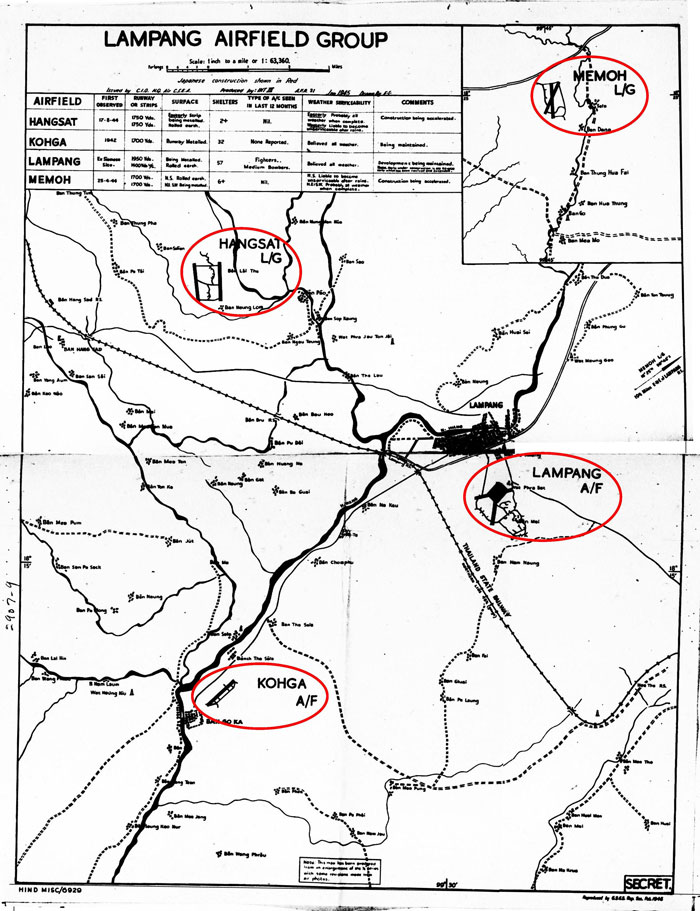
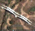
January 1945: A map of the Lampang Airfield Group was drafted during the month. The group consisted of Lampang and Ko Kha Airfields, plus Hang Chat and Mae Mo Landing Grounds:[47å]
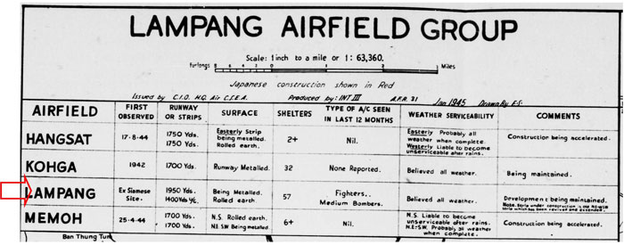
A higher resolution image of the above is available here. The table provided summary statistics for the four installations in the airfield group:[47β]
|
|||||||
|
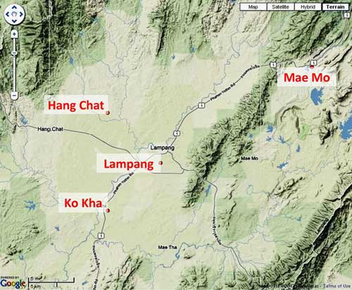
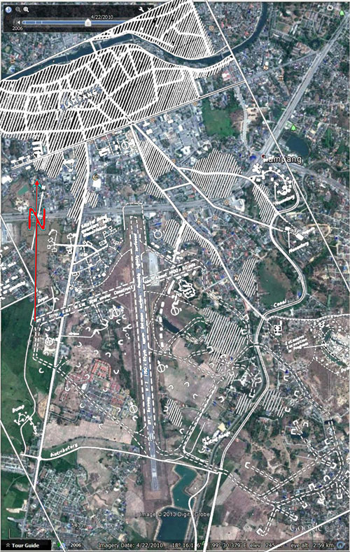
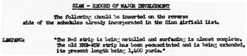
1. The on, then-off, now-on-again, ENE-WSW runway: reported A different rendering of the Lampang Airfield Group, showing it all to be within the Wang River watershed:[47γ]
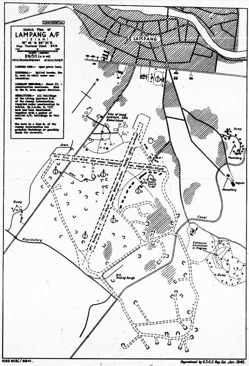
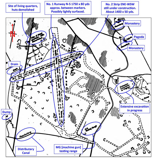
Note that the sketch above is NOT oriented with north to the top of the page, because considerable detail would be lost when necessarily reduced to fit this page. In the discussion which follows, all maps and photos have north is to the top of the page. A higher resolution (and more legible) image of the map sketch is available here. Enlargement of the immediate airstrip area in the map sketch above with original map annotations clarified:[47α]
Sketch Plan of LAMPANG A/F [Air Field] (SIAM) LANDING AREA:- Open grass land. DISPERSAL:- Rolled tracks. The E [east] area is still under construction. AIRCRAFT SHELTERS:- About 57. - Construction continues. Some in the W [west] area appear derelict. DEMOLITIONS:- All buildings of the living quarters NW [northwest] of the runway intersection reported under construction in Oct/43. (DIR No K 137) have now been demolished together with a number of smaller A/F [airfield] buildings in this area. The huts in a line E [east] of the runway intersection are probably workshops or possibly sheds for aircraft.
A higher resolution image of the above is available here.
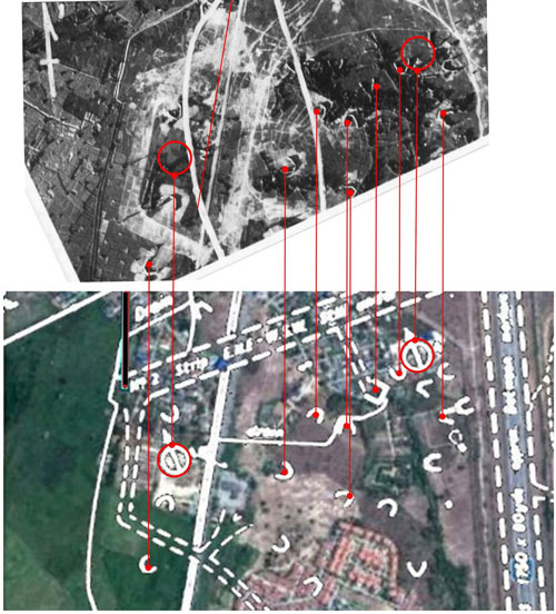
The symbols in the two areas circled in red above represent unoccupied gun emplacements. The various symbols above, looking similar to "U" or "V", in different orientations represent single aircraft shelters. The one squared off symbol, "⊔", shown just SW of the gun emplacement on the right, represents a shelter for two aircraft; while shown as a symbol on the sketch, that shelter does not appear in the aerial photo (which had been taken at least five months before the sketch was dated). The count for such shelters on the sketch was "about 57". A higher resolution image of the annotated pictorial above is available here. Needless to say, there is no evidence on the ground today of those structures.
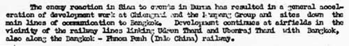
TRANSCRIPT of relevant portion: The enemy reaction in Siam to events in Burma has resulted in a general acceleration of development work at . . . the Lampang Group . . . . TRANSCRIPT:
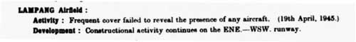
TRANSCRIPT: LAMPANG AIRFIELD: Activity: Infrequent cover failed to reveal the presence of any
TRANSCRIPT: Lampang Airfield:
TRANSCRIPT: LAMPANG Airfield:
The movement of the 4th Division from Sumatra to Bangkok, via Malay by rail, began in February 1945 but was not completed until June. The main body of the division proceeded to northern Thailand by motor transport to prepare for subsequent operations.[54å] (At that time the Thailand railroad was operative only in sections as most of the important bridges had been destroyed by Allied air attacks from bases in India. Most of the locomotives in northern Thailand had been destroyed and this part of the railroad had virtually ceased to operate.)[54β] In the northern Thailand area, the main body of the 4th Division was ordered to stoutly defend the area around Lampang and elements were to construct defense positions so as to defend in depth the Lampang-Chiang Mai Road and the Lampang-Luangnua Road.[54γ]
On the 10th June 1945 [IJA] 39th Army began to tighten its hold on Siam. Unwanted airfields were put out of action, defences were prepared at Bangkok and Lampang, and measures were taken to protect key roads.[54δ] Functionality of the airfield at Lampang would probably have been maintained in keeping with its key position in the defense of Thailand.
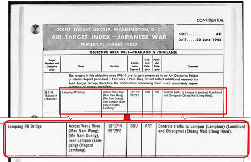
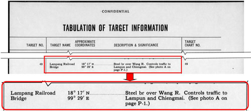
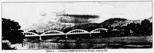
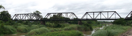
and However, in the same publication is this photo: The photogenic bridge pictured is captioned: Lampang TARGET 49 Railroad Bridge, looking NE However, it is actually the Ratchadaphisak (สะผวนรัษฎาภิเสก), a narrow vehicle bridge crossing the Wang River about 5 km upstream of the rail crossing. Almost obscured by trees along the river bank, it looks like this today:
Neither bridge was apparently damaged during the war. Both still stand today.
The main body of the [IJA] 4th Division was disposed in northern Thailand by the end of June and generally had completed construction of the positions in strategic sectors.[54d]
In early July, the [IJA] 15th Army headquarters moved from Bangkok to Lampang in northern Thailand . . . .[55a] As such, the unit was absorbed as a subsidiary unit into the 18th Area Army.[57]
"Outline of [the IJA] 18th Army's Operation Plan" included: . . . Powerful groups capable of securing the strategic areas of northern Thailand without outside support will be stationed in northern Thailand to hold the enemy at bay. " Disposition of forces" included: 15th Army Headquarters, 4th Division (less 61st Infantry Regiment and two artillery battalions, and 56th Division. The 15th Army will defend strategic sectors in northern Thailand without outside support. . . . The 56th Division will . . . secure the vicinity of Lampang . . . . "Traffic" included: The main roads . . . to be secured. . . . As much as possible of the actual road construction as possible will be assigned to Thailanders. . . .
Lampang Williams‑Hunt Aerial Photomosaic
RTA, and presumably RTAF, personnel who had ended the war in Kengtung did not fare so well: RTAF aircraft which could not be flown out of Kengtung were intentionally destroyed on the ground to prevent them falling into Chinese hands.[59d] Thai troops proceeded on foot down the roads connecting Kengtung to Phitsanulok. Long neglected and poorly equipped, the units returned barefoot to Lampang; between there and Phitsanulok, the Thais continued to march barefoot as they watched railcars transporting IJA troops heading south.[59e]
|
47å.^ Airfield Report No 31, Feb 1945, unnumbered pages, dated Jan 1945 (USAF Archive microfilm reel A8056 pp0003-0006). Note that map carries the date "Jan 1945" Runways at Lampang and Ko Kha were labeled "airfield" which meant "all facilities" were believed by Allied intel to be available, whereas Hang Chat and Mae Mo were labeled "landing ground", which were to serve more an emergency / backup function. 47β.^ ibid (extract)
47γ.^ "Terrain" map from Nations Online Project: Searchable Map and Satellite View of Thailand using Google Earth Data. Annotations by author.
47.^ Airfield Report No. 30, Jan 1945, unnumbered page (USAF Archive microfilm reel A8055 p 1202). See Appendix B. Notes on symbols used in USAAF airfield sketches.
47α.^ ibid. Annotations by author using Microsoft Publisher.
47a.^ Image consists of: Google Earth Imagery data: 22 April 2010 Overlay as recorded in note 47 above, processed with Adobe Fireworks and added with PhotoShop.
47a1.^
47b.^ Image consists of: Extract from Google Earth: Extract from overlay as recorded in note 47 above, processed with Adobe Fireworks and added with PhotoShop. Extract of aerial photo recorded in note 34b. Annotation added with Microsoft Publisher.
47c. deleted.
47d.^ Extract of aerial photo recorded in note 34b. 47e.^ Extract of aerial photo recorded in note 34b.
48.^ Airfield Report No. 30, Jan 1945, "A Survey of Present and Future Trends in Japanese Airfield Development", p i
49.^ ibid, p 12 (USAF Archive microfilm reel A8055 p 1276)
50.^ Airfield Report No. 30, Jan 1945, "Record of Airfield Activity and Development", p 7 (USAF Archive microfilm reel A8055 p 1270)
51-52. (deleted)
53.^Airfield Report No. 32, Mar 1945, "Record of Airfield Activity and Development", p 7 (USAF Archive microfilm reel A8056 p 0126)
54.^ Airfield Report No. 33, Apr 1945, "Record of Airfield Activity and Development", p 3 (USAF Archive microfilm reel A8056 p 0165)
54å.^ Japanese Monograph No 177: Thailand Operations Record, p 22.
54β.^ ibid, footnote 20.
54γ.^ Japanese Monograph No 177, ibid, p 27.
54δ.^ Kirby, S Woodburn, The War Against Japan, vol 5 (Uckfield: The Naval & Military Press Ltd, 2004) p 292.
54a.^ Excerpted from three pages in NARA Publication Number M1653: "WWII Japanese air target analyses, objectives, and aerial photographs, 1942-45, from the records of the U.S. Strategic Bombing Survey." 1. Roll 01, Sect 1-a, Item 2 Target location: nominal: "N18°17 E99°29", but While printed matter here is dated 20 June 1945, NARA ref cards date all three documents as 01 Feb 1943.
54b.^ Photo extract from "Lampang Province", Wikipedia Bridge was erected in 1918, replacing a two-span wooden structure which had been destroyed by teak logs floated down the river by logging companies (Oliver Backhouse email of 0358 11 Mar 2016). Curiously there is a railroad bridge (railway approx sta 690+360) of similar appearance, though only of two spans, about 48 km further north along the track at N18°30.64 E99°13.09: This bridge crosses the Mae Nam Thai near Ban Tha Champhu Rail Station. As conspicuous as it would have been to Allied aerial reconnaissance, the bridge was not recorded as having been attacked. It was not a large bridge 54c.^ DSCF1588 of 25 Jul 2013. Bridge: railway station 643+470 (per Whyte, p 28) 54d.^ Japanese Monograph No. 177: Thailand Operations Record, p 34. 55.^ For details, see Demezas. Further research on Demezas is needed. 55α.^ Wikipedia: 18th Area Army. 55a.^ Japanese Monograph No 177, ibid. 56. (deleted) 57a.^ Japanese Monograph No 177, pp 31-33.
58.^ ibid. 59.^ Wikipedia: 18th Area Army.
59a.^ Kirby, ibid, p 295.
59b.^ ibid, p 296.
59c.^ ibid.
59d.^ Need reference. 59e.^ Axis History Forum. Wisarut Bholsithi in "Thailand in WWII photos" on 21 Jun 2004. At Phitsanulok, Thai troops were finally given access to rail transportation.
|
||||||