| N18°34.06 E99°02.48 | Lamphun Airstrip (Th: ทางวิ่ง ลำพูน / Jp: ランプーン 滑走路 ) page 2 of 6 |
Route 0011 |
| Text | Notes |
|
From 16 to 25 March 1942, Combined Wings 80 and 90 sent Curtiss Hawk III and Vought Corsair aircraft to scout areas and oppose the enemy in its attacks on the airports at Chiang Rai, Chiang Mai, and Lamphun.[5b]
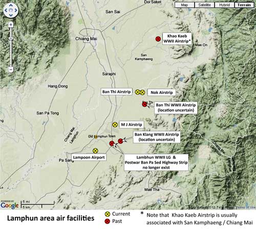
On 24 March 1942, Flying Tiger, Frank Lawlor, accompanying Jack Newkirk on his fatal flight,[5c] recorded that they had circled Lamphun town, flying over "two small satellite fields", and then a "third and larger field". No aircraft were sighted at any of them; however the last had "several barracks", which they strafed.[5d] Lawlor then recorded that Newkirk turned north, apparently to return to Chiang Mai.[6] To review, Lawlor reported three airfields: "A larger field", which would have been the "Lambhun military landing ground", noted in the US War Department's 1940 Report above. "Two small satellite fields", which the War Department report made no mention of; however, certain assumptions can be made: Local Chiang Mai photographer / historian Boonserm Satrabhaya writes: When Japanese airmen first used Chiang Mai Airport, the Royal Thai Air Force (RTAF) shared the airport with them for some time until the RTAF moved their planes to airports at: . Chiang Rai 1. Ban Klang: ground preparations must have been well advanced, or completed, for two days later, that field was occupied by RTAF aircraft (see 26 March 1942 entry below). Unfortunately, no information about the airstrip has been found. Its location is not recorded. There is a village with that name east of Lamphun town that shows up on various maps at approximately N18°34.5 E99°04:[6b] about two kilometers east of the larger "Lambhun military landing ground". Details (particularly bearing and length) are also unknown. 2. Less clear is an identity for the other "satellite" airstrip. There are two candidates, one fairly well documented, one not so: First, Khao Kaeb, as mentioned by Boonserm: San Khao Kaeb Lan Dtong in San Kamphaeng. Tha Noisuya, another local resident, recalls the same airstrip: During the war, there was another airport besides Chiang Mai airport that was used. A temporary airstrip was built at Ban San Kaokab, Moo 3 and Moo 5, Tambon Huai Sai, Amphoe San Kamphaeng. They flattened a rice field, added sand and compacted it, and used the result as a runway. The runway was about 500 meters long. Seven airplanes parked there. Once in a while, Japanese soldiers would ride to it on a motor tricycle. The officer would sit in the front of the tricycle. They came to check their planes. These planes all had Thai pilots. Everyday there was training: they tied cloth in trees and used it for target practice. This airport lasted for a half a year, and then it was closed as the rainy season was approaching.[6c] On 21 July 2011, this author with wife as translator went into the area to inquire about an old airstrip. Local government offices did not know of it. Eventually via various wats, and some of them were quite basic ‑‑‑ not all wats are beautiful and well-maintained, we found enough "old" folks to develop a concensus on the likely location, N18°47.246 E99°08.861, which is right in the middle of paddy fields, just as it was in 1942. Seventy years of cultivation have disguised (distributed) any evidence of sand fill. But a second candidate, Ban Thi, seems to be only a word-of-mouth recollection, not recorded on paper. However, presumably somewhere southeast of Ban Thi village.(N18°39.1 E99°07.5), it is much closer to Lamphun than Khao Kaeb. This requires further research.[6d] The four locations, one, real, "Lambhun" and the others, speculative, are summarized here, along with locations of current air facilities for reference:[7]
An inspection of the map suggests that neither Khao Kaeb nor Ban Thi is a realistic candidate for a "small satellite field" visible when the pilots "circled" Lamphun (see guesstimated path for "circling" Lamphun; and note that map's larger scale). Khao Kaeb is almost as far away as Chiang Mai. Ban Thi is closer, but far from the rail line which the pilots followed into town. It is possible that the pilots' reports were in error: they might, say, have mistaken a section of straight road close in to town for a runway. On 26 March 1942, Squadron 42 of Combined Wing 90 moved from Chiang Mai to Ban Klang, Lamphun.[7a]
|
5b.^ RTAF 1913-1983, p 316. RTAF unit terminology: from Young, who also provided the transliteration "Kong Bin Noi Phasom". 5c.^ See Wat Phra Yuen. 5d.^ Royal Thai Air Force history confirms that the airstrip at Lamphun was attacked: ประวัติกองทัพอากาศไทย ในสงครามมหาเอชียบูรพา พ.ศ. ๒๔๗๔ ๑๔๗๗ กองทัพอากาศ พ.ศ. ๒๕๒๕ See discussion at Wat Phra Yuen. 6.^ Bergin, Bob, ibid.
6a.^ บุญเสิม สาตราภัย เชียงใหม่กับภัยทางอากาศ (กรุงเทพฯ: วิญฌูชน, 2003)
6b.^ Sources:
6c.^ The "year" referred to was apparently 1942. สังคมเมืองเชียงใหม่ เล่ม 2 พ.ต.ท. อนุ เนินหาด พิมพ์ครั้งที่ 3 พ.ศ. 2549, "Chiang Mai in World War II", Chiang Mai: Numerous Stories of Yesterday (Chiang Mai: Krong Chang Printing, 2006) ISBN 974-85311-9-8, p 62. 6d.^ Tony Smallwood to David Hardcastle email of 26 Oct 2008 1050 hrs.
7.^ Map is a "Terrain" map from Nations Online, ibid, with annotations by author using Microsoft Publisher (note that this map also appears on page 6 of this article).
7a.^ RTAF 1941-1945, p 94.
|