Japan in Northwest Thailand during World War II
| N20°08.8 E99°51.2[1] |
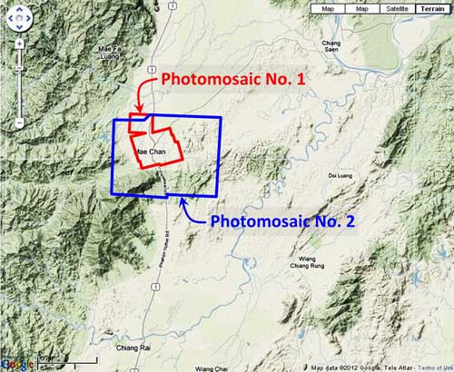
Mae Chan (Th: แม่วัน / Jp:メーチャーン ) Williams-Hunt (W-H) Aerial Photomosaics Page 1 of 1 |
Route 0001 |
| Text | Notes | |||||||||
|
This page discusses World War II aerial photos taken by the Royal Air Force (RAF) and provided on-line by the Geo-spatial Digital Archive Project (GDAP) in its Williams-Hunt Aerial Photograph Digital Collection.[2a] The Williams-Hunt collection has two separate sets of aerial photos for Mae Chan:[3]
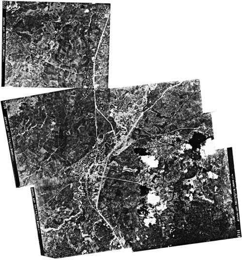
In the following, aerial photos were joined into mosaics using Microsoft ICE (Image Composition Editor) as much as possible. Photomosaic No. 1 The area around Mae Chan outlined above in red was recorded in seven RAF aerial photos taken on 05 October 1944:[4]
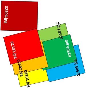
A higher resolution image is available for download here. The following GDAP images were used in the above photomosaic:[5] 02501.jpg and assembled approximately like this, using a combination of Microsoft ICE and manual fitting:[6]
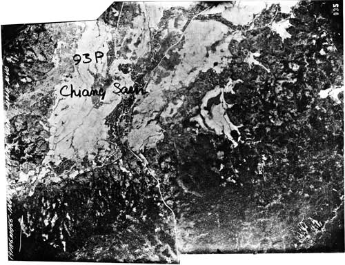
An alternate, macro, two-photo view, undated, as outlined in blue on the site map above, was also recorded:[7]
A higher resolution image is available for download here. The handwritten "Chiang Saen" is irrelevant here and is discussed at Chiang Saen. The following GDAP images were used in the above photomosaic: and assembled approximately like this, with ICE:[8]
|
See Key for interpreting page content. Revision list. See bottom of Text column on this page. Bibliography supports notes. 1.^ Source: Google Earth fix on apparent center of town. 2.^ Stationing needed. 2a.^ The collection and its origin are described in detail in: Lertlum, PhD, Col Surat, and Dr Elizabeth Moore, Williams-Hunt Aerial Photograph Collection, (undated); available as here linked. Moore, Elizabeth, The Williams-Hunt Collection, Sari - International Journal of the Malay World and Civilisation, 27(2)(2009), pp 265-284. Periasamy, Makeswary, "A View from the Top", biblioasia, 5(1) (Apr 2009), pp 38-42. 3.^ "Terrain" map from Nations Online Project: Searchable Map and Satellite View of Thailand using Google Earth Data. Annotation (red & blue colored items) placed with PhotoShop by author.
4.^ Photos were assembled using Microsoft ICE (Image Composition Editor) as much as possible. Order of assembly was important: images 02501-02503 and 02505-02507 were assembled first and then joined. 02504 had to be manually added to the resulting composite because it did not sufficiently overlap with the other photos for the ICE program to stitch them together. Mosaic has been oriented so that its north is to the top of the page.
5.^ The files used here are 1024 KB. Downloading the files which are designated "[full size]" requires a special request form to be emailed to the Head, GDAP.
6.^ Drawn with Microsoft Publisher by author.
7.^ Photos were assembled using Microsoft ICE (Image Composition Editor). Mosaic has been reoriented so that its approximate north is to the top of the page.
8.^ Drawn with Microsoft Publisher by author.
|
|||||||||