| N18°47.235 E99°00.320 |
Morinosuke Tanaka (Th: ทานาคา / Jp: 田中盛之助 ) |
Route 0106 Station 000.5 |
| Text | Notes |
|
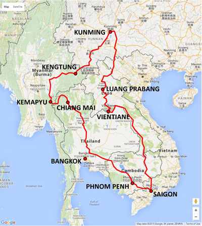
1930-1942: During this period, Tanaka became more and more involved with the IJA as preparations were made in the eventuality of a Japanese presence in Thailand and an invasion of British Burma. 1930: In Bangkok, Shu Hatano had worked for 16 years in the photo shop of his brother, Shozo Hatano. In 1930, Shu was approached by an IJA Colonel Kanji Tsuneoka who pressed Shu to accompany him to Chiang Mai where the colonel was to meet Tanaka; the colonel identified himself as a military attache at the embassy in Bangkok. Shu was acquainted with Tanaka from his trips to Bangkok to purchase photographic supplies. Obviously there would have been some discussion between the colonel and Shu's brother, and possibly Tanaka, regarding the use of Shu.[39] There is some evidence that the colonel looked upon Shu Hatano as a potential assistant.[39a] In August, the colonel and Shu journeyed to Chiang Mai. Tanaka left his shop in the hands of the just arrived Shu and disappeared with the colonel for "many days". In the late 1980s, Shu recalled that Tanaka told of having traveled around Burma, Laos, China, Vietnam, and Cambodia with the colonel, collecting information.[39b] If one journey had covered all objectives, a very broad brush itinerary for a hypothetical journey might have been:[39c]
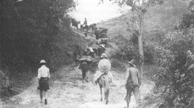
Moving clockwise from Chiang Mai to Kemapyu-Kengtung-Kunming-Luang Prabang-Vientiane-Saigon-Phnom Penh, 6,000 km on foot / horse / motor vehicle to Aranya Prathet, plus 1,000 km more by rail from Aranya Prathet back to Chiang Mai; for a total of 7,000 km. At that time, land travel was often over trails such as this:[39d]
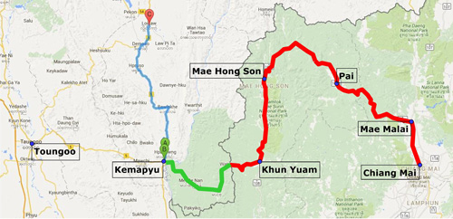
The distance over roads of this type could represent about 200 days, which would certainly constitute Hatano's "many days".[39e] The motivation for this effort was probably uncertainty about a growing conflict in China between the forces of Mao Tse Tung and Chiang Kai-shek, and about the intentions of Britain and France whose possessions bordered Siam. An additional motivation was evaluating a potential road route from Chiang Mai through Mae Hong Son and connecting to, probably, an existing road at Kemapyu in Burma. With the return of the pair, Shu got the impression that thereafter Tanaka always had a reliable supply of photographic materials and equipment[40] (however, Hatano made this observation with no idea of what might have transpired between Tanaka and the IJA, prior to his (Shu's) arrival in Chiang Mai in 1930). 1931: In April, Colonel Tsuneoka was promoted to the army general staff and left Siam.[41] 1933: In accord with an agreement with either the colonel or a successor,[41a] Tanaka began a "terrain survey" along the Burmese border. The assignment apparently included setting out a route where none had existed between Chiang Mai and Mae Hong Son through Mae Malai and Pai --- after the war, Tanaka's effort would evolve into Thai Route 1095.[42] If he traveled west at that time into Burma seeking a connection with Burma's existing road system is not clear. However, IJA planning in 1943 for access from Chiang Mai to Burma mentions only Toungoo as a western terminus. Mae Hong Son is never mentioned in describing the road.[42a] Hence, it seems reasonable to assume that Tanaka did in actual fact venture into Burma, to connect with an existing Burma road (current Burma Rte 5) near Kemapyu:[42a1]
The distance between Chiang Mai and Kemapyu is about 385 km. At a walking speed of 3 km per hour,[42b] 10 hours per day, Tanaka would have taken 13 days just to get to the far end of his project, plus an equal interval to get back, plus time expended in survey work. It seems to have been a one-man assignment, and, as such, it was necessarily long term. 1935: Tanaka was in Chiang Mai to record the dedication of the road to Wat Doi Suthep, built by the monk, Kruba Sriwichai:[42c]
1939: Shu Hatano married Tanaka's daughter, Kumpoon.[43] Between 1930 and 1939, Tanaka performed "many surveys" in Laos.[44] Matsumoto recalled a photo that Hatano had shown him, and which the author duplicated in his book, of Tanaka dressed in Laotian clothing with a Japanese medal on his chest. The photo was dated "immediately following WWII", in Chiang Mai.[44a] 1940-1941: From October 1940 to May 1941, Siam fought French forces in French Indochina in an attempt to regain control of territory lost during King Chulalongkorn's reign. The war was characterized as a defeat for Siam on the sea, but a victory in the air. Japan chaired peace negotiations, and ensured that France returned all the disputed territory to Siam.[45] For an indeterminate number of years prior to the Franco-Thai War (1940-1941), Tanaka had traveled at least once a year to Saigon at the request of an embassy military attache. Hatano recalled that Tanaka's photo subjects had seemed to center on French warships.[45a] 1941: "In mid-March, Tokyo ordered the opening of another [consulate] in . . . Chiang Mai . . . . the new offices were designed primarily as intelligence-gathering posts."[46] In February, representatives of the Minami Kikan [Minami Organ (organ as in organization)], an independent arm of the IJA, had been charged with supporting and liaising with the Burma Independent Army (BIA). Among their objectives was setting up liaison points on the Thai-Burma border.[47] Four liaison points were subsequently set up, with the most northerly of them being Chiang Mai.[48] There it functioned as a commercial, mining, forestry, and / or development organization which allowed it the freedom to investigate remote areas.[48a] Tanaka would not have been designated the Minami Kikan representative in Chiang Mai for its members had been carefully selected and specially trained in working with the BIA in Burma in combat conditions. However, tasks set out for the Minami Kikan effort included "reconnaissance . . . to be made of the topography and roads from the Thai border into Burma, and a military geography compiled."[49] For this last, it would appear that Tanaka must have been a major resource for the Minami Kikan: thus he would have been quite busy during most of 1941. July 1941: In various despatches to FO [Foreign Office], Crosby [der britische Gesandte Josiah Crosby, 1880 - 1958] reported Japanese infiltration. An obvious one was in July when a Japanese Camera Department came and sent out teams of photographers to record the "cultural entente" between Thailand and Japan. A secret source imparted that a complete list of films already produced included highways, anti-aircraft facilities in Thailand, aeroplanes, the salt industry, British firms in Thailand and various government workshops. Crosby commented that Thai Government probably knew but dared not oppose it. Then came the Increase in Japanese tourists to Thailand, especially in the south, in October 1941.[49a] On 01 December (?), a Mitsui employee in Bangkok recalled that Japanese residents were called together "several days" before the "invasion" to be told that the IJA would invade on 08 Dec 1941. Whether this information found its way to Chiang Mai is unknown.[50] 08 December: IJA troops entered Thailand. 15 December: IJA personnel first appeared in Chiang Mai.[51] Boonserm recalls that Tanaka was at the railway station to greet the first IJA troops to arrive. It is apocryphal that Tanaka was wearing a uniform when he met the first troops. However, Boonserm smiled at the story and said such was not the case. Boonserm, 13 at the time, did not claim to have been present at the rail station when the IJA troops arrived. His cousin, Wichit Jayavann, 17, claims to have been present and strongly asserted that Tanaka did welcome the incoming IJA troops in his own uniform, with rank of major.[51a] While Tanaka was obviously serving his country and his country's army, he was not doing so in a military capacity. Had Tanaka been authorized to wear a military uniform at his age of 66, he would likely have been the most senior member of the IJA.[52]
1942-1945: The war years. 1942: "Mr Tanaka was Lord Mayor of Chiang Mai from 1942-1945."[53] One source limited Tanaka's assistance for IJA and IJAAF components in Chiang Mai to just "food procurement".[54] However that would be inconsistent with his activities before the war, as already described. That source also asserted that Tanaka had been required to join the IJA.[55] Hatano said that he himself had been allowed a deferment as a Japanese expatriate.[56] Neither joining up nor dealing with deferments seems likely, with age the determining factor for both in 1941: Tanaka at 66 and his son-in-law at 41 were simply too old. No doubt, Tanaka, who had been active in sports, maintained a physical fitness which allowed him to work closely with the IJA in the field throughout the war, but that would not have entailed actually joining the army. And Hatano was unlikely to have been eligible for conscription (though, as Japan's war losses grew, the age range draft was broadly extended, but not in Thailand).[57]) Hatano's participation in the war effort, he said, was limited to serving as a translator between the IJA and Thai labor improving Chiang Mai's airstrip.[57a] On 12 March 1942, the 2nd Railway Command Group chose the Kanchanburi-Thanbyuzayat route for what later became known as the Thai-Burma Death Railway. Prior to that date, the group had evaluated several alternate routes including extending the railway from Chiang Mai to Toungoo. The speed with which the decision was made suggests that the route was not field checked; Tanaka might have been consulted about the matter.[57a1] On 24 March 1942, Tanaka would have witnessed the first air attack on Chiang Mai. It evolved in two stages, first an early morning strafing of the railway station by Flying Tiger P-40s which overflew his shop, and second a strafing of the airfield by more P-40s a few minutes later. In the latter case, while the field itself would have been obscured by the many tall trees in Chiang Mai, Tanaka would have been able to see the aircraft making their strafing runs:[57b]
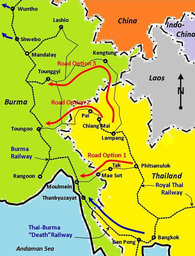
1943: The IJA's Southern Expeditionary Army Group had found early in the war that supplying its forces in Burma by sea was too vulnerable to attack by Allied submarines. The group's solution was to reduce that exposure by establishing land routes between Thailand and Burma. By early 1943, the Thai-Burma[57g] and the Kra[57h] railways were in various stages of construction to alleviate that supply route problem. To yet further secure supply access to Burma, the army group wanted also to set up a vehicle route through the north of Thailand.[57i] Three potential routes were reconnoitered:[57j]
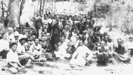
Road Option 2 in the map above was what Tanaka and Colonel Tsuneoka had investigated during the colonel's visit in 1930. And for which Tanaka had performed a terrain survey starting in 1933. Hatano consistently referred to this road as the "Chiang Mai-Mae Hong Son Road"; never the "Chiang Mai-Toungoo Road".[57l] However, Japan's official military history only called it the latter.[57m] In reevaluating the route in 1943, Tanaka would have been an invaluable asset, and in August, "his" road, Option 2, would be approved for construction / improvement. Also in January 1943, the Southern Expeditionary Army Group had put IJA Lt Gen Aketo Nakamura [中村 明人] in charge of the Siam Garrison, headquartered in Bangkok.[57n] In late March-early April,[58] the general visited the Phayap Army Headquarters in Chiang Mai. The visit included a "photo op" which was displayed at the Boonserm Satrabhaya Historical Photo Exhibit at the Sriprakard Hotel in February 2011:[59]
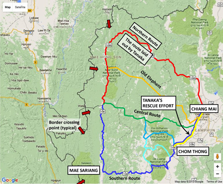
1. Chiang Mai Consul This photo could be assumed to clearly evidence the high esteem with which the military power structure regarded Tanaka and his son-in-law, Hatano. And that can be assumed to have been earned by providing material assistance to the military. Alternately, Tanaka's presence in the photo might be explained by his title of Lord Mayor of Chiang Mai; that would not explain Hatano's presence, however. On 12 August, the IJA's Burma Area Army was ordered to prepare for the invasion of India via Imphal and Kohima. Within that army, the 15th Division was designated to construct / improve the Chiang Mai-Toungoo Road[60] and thereafter the division was to use it to go to Toungoo, and from there on to Imphal. The 15th Division at that point was in process of moving in increments from Shanghai[61] to Thailand and those units which had arrived, the advance units, were assigned to road construction.[62] The work had to be completed in two months, ie, by mid-October 1943,[63] so that the 15th Division could be in place for the attack on Imphal, planned for 11 February 1944[64] Since Tanaka was intimately familiar with the route, he probably would have been directly involved, at the least as an adviser, in this effort. While it was almost immediately apparent that the road could never be finished by mid-October,[65] higher command was adamant in continuing the not-yet-completed road work past that date in hopes of finishing it. Finally, on 09 November, the command relented and agreed that the 15th Division could use the existing Lampang-Kengtung-Takaw Road to move to the Imphal area.[66] However, approximately a third of the 15th Division was retained to continue constructing the road (and other duties).[67] And Tanaka's presence would have continued to be required on the extended project effort into 1945.[68] 21 December 1943: Tanaka might have been witness to the worst bombing Chiang Mai endured during the war. Allied aerial recon photos had recorded 15th Division troops concentrating at the Chiang Mai railway station for transport to Lampang.[69] No doubt believing the troops were preparing an aggressive move, and that the Chiang Mai railway station was central to that effort, 29 B-24s bombed the rail station on 21 December 1943,[70] killing around 300 people.[71] However, the last of the 15th Division units going to Imphal had left Chiang Mai on 18 Dec 1943;[72] so the death toll of 300 from the Allied bombing was almost entirely Thai civilians.[73] 1944: Two sources described Tanaka as leading IJA troops to "Burma",[74] or "Imphal".[75] There are problems with these statements. As noted above, IJA troops, the 15th Division, did not advance into Burma via the Mae Hong Son Road --- the construction of which Tanaka was helping oversee; instead they used the older, traditional route via Mae Sai to Kengtung, Takaw, and Meiktila. Further, Tanaka would probably have been receiving direction from General Nakamura, whose Siam Garrison was part of the Southern Expeditionary Army Group, which was directly overseeing the construction of the road, not the invasion of Imphal.[76] Thus, Tanaka would probably have continued overseeing construction of the road accessing Toungoo. It was eventually completed in July 1944,[76a] after the IJA had been defeated at Imphal. It would later provide one avenue (of many) of retreat for IJA troops devastated from a series of disastrous defeats starting with and continuing after those at Imphal and Kohima.[77] The large number of IJA troops who died on the road from wounds, malnutrition, and disease, with their bodies left where they had died, led to alternate names for the Toungoo-Chiang Mai Road: Skeleton Road, Road of Bones, etc.[78] Actually that sort of name was applied to many roads along which IJA troops died during the retreat. 1945: Most of the alternate routes of retreat out of Burma led into Thailand with objective, Chiang Mai. Because of the many different border crossings used, many existing roads were followed within Thailand, including Tanaka's. One such road, the Southern Route, went through Mae Sariang to Chom Thong and on to Chiang Mai:[79]
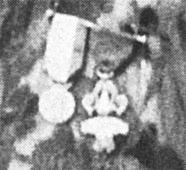
When the district chief at Chom Thong saw the many desperately ill and wounded Japanese troops streaming through his town, he got word to Tanaka, whom he knew. Tanaka responded by commandeering a wood-burning vehicle and driving to Chom Thong two or three times to ferry back the most afflicted to medical facilities in Chiang Mai.[80] It is ironic that Tanaka ran this rescue effort over a road other than the one he had helped construct; nonetheless "his" road was the one that most retreating IJA troops followed to Chiang Mai. A retired military intelligence officer, nominally the former military attache for the second class secretary at the Japanese consulate in Chiang Mai, reminisced about his assignment in Thailand, and summarized his view of both Tanaka and Hatano: "Those two both cooperated really well with the army".[81] October 1945: In an apparent sweep of all Japanese Nationals in Thailand after the war, both Shu Hatano and Tanaka were detained by Allied forces and sent to Bang Bua Thong internment camp, to arrive on 20 October 1945. They stayed with other Japanese, almost all of whom elected to return to Japan. But Tanaka and Hatano opted to stay. Tanaka confided to Hatano his fear that he would be tried for war crimes should he return to Japan.[82] Tanaka told a military acquaintance at the end of the war that he could not leave Chiang Mai (to return to Japan), perhaps implying a responsibility he felt towards his family in Chiang Mai.[83] 1946: Tanaka and Hatano were released 21 November 1946 from the internment camp. Tanaka was 71.[84] Tanaka reopened the photo shop on the Ping River, with a new name, "Chiang Mai Photo Shop" and turned it over to Kumpoon and Hatano to operate.[85] One source lamented that, when the IJA lost the war, no medal or remuneration could be offered to Tanaka for his loyal and substantive service.[86] Unaware of that comment, Matsumoto included in his book a photo of Tanaka in Laotian clothing, dated "immediately after the war", wearing on his chest what were called Japanese medals:[87].
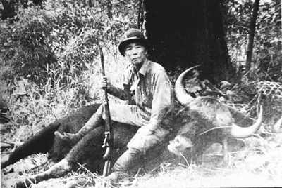
However, the more distinctively shaped of the two medals (on the right) has been identified as Laotian and registers which still exist do not record its issue to Tanaka.[88] While the photo was dated "immediately after the war", it would necessarily have been some time after Tanaka's return from the internment camp in October 1946. Following the turnover of his shop to Kumpoon and Hatano, Tanaka in his semi-retirement made numerous trips on "his" road to Mae Hong Son where he offered his photo services, as before the war. Those trips were expeditions with horses and porters carrying photo gear and luggage.[89] During those trips, he would indulge his love of hunting; there is a photo of Tanaka sitting astride a wild buffalo he had shot on one of those trips. It is dated 1955 --- he would have been an active 80 years old:[90]
Since it was an annual event, Tanaka eventually kept his photo equipment there in Mae Hong Son. When he finally had to give up those annual jaunts, the photo gear was not retrieved and its fate is unknown.[91] It should be noted here that Tanaka never used any other than a view camera with glass plate negatives.[91a] The view camera was cumbersome, but it produced photos vastly superior in quality to that of the more portable types of cameras, starting with the Kodak Brownie box camera in 1900 and evolving into the first commercially viable compact single lens reflexes in the mid-1930s. Hatano described Tanaka as someone who had been involved with (Japanese) intelligence --- with old habits hard to break: this while recalling Tanaka seated close to a barely audible shortwave radio, ear almost touching it, listening to news about the situation in Dien Bien Phu, which was then under siege in 1954.[92] Long after the war ended, Tanaka, Lord Mayor of Chiang Mai during the war, presented Luang Sriprakard, the current Lord Mayor, with cherry tree saplings given by the people and government of Japan in appreciation for the support that Thailand had given Japan during the war:[93]
Tanaka died on 22 October 1961 at age 86.[94] A tomb marker was erected at Wat Tha Satoi, only half a kilometer from where his shop had been located.[95] His age at death on his memorial at the wat reads 88, which is in error.[96] Hatano before dying thirty years later asked that his tomb be placed next to Tanaka's.[97] Aftermath As noted at the beginning, Tanaka is currently remembered for his significant contribution to the photographic imagery of the Chiang Mai area in the early 20th century. But he must also be remembered for having established the routing of present-day Thai Rte 1095 between Mae Malai and Mae Hong Son, The Road of a Thousand Curves,[97a] and for having fostered friendly relations between the IJA and the Thai populace in northwest Thailand during the war.[97b] Matsumoto describes Tanaka as having been permanently scarred by his involvement in the disastrous defeat at Imphal and his neglect of his other family in Japan.[98] If true, it would certainly have been a demonstration that Tanaka was not a cold blooded, heartless agent of the state. With regard to his contribution to the defeat at Imphal, at most, Tanaka provided information about a proposed route to Toungoo, for a military command reviewing a total of three alternative routes. Tanaka had explored that route with Col Tsuneoka in 1930 and the colonel had apparently given it his endorsement, for Tanaka began a terrain survey for it in 1933. In any case, it was a command decision, not Tanaka's, that designated the Chiang Mai-Mae Hong Son-Toungoo routing. If the information Tanaka provided had been inadequate or misleading, the command was at fault for having profoundly understaffed the field work for a route of approximately 385 km. Nor could Tanaka be blamed for equipping road construction crews with only shovels and hoes.[99] The Allied effort in constructing the Ledo Road of approximately 735 km through somewhat similar terrain with 50,000 workers equipped with modern highway construction machinery and supplied with prefabricated bridges and buildings, contrasts the appallingly poor quality of planning and construction support provided by Japan's military staff. That the 385 km Chiang Mai-Toungoo Road was eventually completed to a specified four meter width by July 1944[100] is a testimony to a tenacity and innovative spirit in the 15th Division.[101] With regard to Tanaka's apparent neglect of his family in Japan, that was rather a personal sacrifice he had consciously made to serve his country. While Matsumoto condemned Tanaka for his failure to return to Japan, he also acknowledged that other Japanese had responded to a similar motivation.[102] He had been led to believe that Japan would prevail in this conflict. Had that occurred, and he was seen to have played a part in it, perhaps he might have felt he would be forgiven by his family in Japan. But he wasn't aware, nor were 70 odd million other Japanese[103] of the profound shortsightedness of their country's leaders. Or, to put it more simply, Tanaka had the misfortune to have been on the losing side.[104]
Colonel Phraya Mahanarongruengdej [พระยามหาณรงด์เรืองเดช] (Plaek Julakan), Commander, Thai 13th Infantry Regiment, in Chiang Mai, shown with Tanaka and Gen Nakamura in photo above - a partial list of accomplishments:[A01] 1926: As a Lt Col in the 17th Infantry Regiment at Fort Surasakmontri (Lampang), he had Ban Pong Nak, "the house with many windows", built to house King Phrajadhipok and Queen Rambhaibhanee during their visit which began in Jan 1927 (The structure was used for another Royal Visit in 1958 and is currently used as a local museum). 1931: Commander of the 2nd Infantry Regiment - Royal Guard (now the 11th Infantry Regiment - Royal Guard). 1932: The regiment was dissolved into the 4th, 5th, and 6th Infantry Battalions. 1932: The 8th Infantry Regiment (the Chiang Mai Regiment) was downgraded to become the 14th Infantry Battalion. 1936: The 14th Infantry Battalion became the 31st Infantry Battalion after economic recovery allowed army expansion. 1942: The Chiang Mai Regiment, as the 31st Infantry Battalion, was upgraded to the 13th Infantry Regiment of the 4th Division. The 4th Division consisted of: 1. The 3rd Infantry Regiment (including the 4th, 6th, and 8th Infantry Battalions) - headed by Col Luang Kriangdejphichai (Sut Sukhanin). 2. The 13th Infantry Regiment (including the 30th, 31st, and 34th Infantry Battalions) - initially headed by Lt Col Khun Watanayothin (Sord Ratanayantrakarn), then transferred to Col Phraya Mahanarongruengdej (Plaek Julakan). 1946: The 13th Infantry Regiment was retitled as the 14th Infantry Regiment. 1950: The 14th Infantry Regiment was renamed as the 7th Infantry Regiment. Links: กองกำลังพล กองทัพภาคที่ ๓ (Government Organization: Division 3)
|
39.^ Matsumoto, p 195. 39a.^ Matsumoto, pp 74, 197.
39b.^ Matsumoto, pp 74, 197.
39c.^ Map image: Nations Online: Thailand. Distances from:
39d.^ Payap Collection: extract from Image no. 23, undated, by unknown. Photo also appears in Sarassawadee Ongsakul, History of Lanna (transl by C Tanratanakul) (Bangkok: Silkworm Books, 2001), p 233 as No. 104 with caption "The road used by caravans in transporting goods", dated 1942, and attributed to the National Archives of Thailand.
39e.^ That assumes a walking speed of 3 kph and a ten hours of walking per day. The duration would have been reduced if motor vehicles (bus service) were available on any stretch. (TrailTrove: Hiking Speed).
40.^ Matsumoto pp 196, 197.
41.^ Matsumoto p 198.
41a.^ Matsumoto, p 198. 42.^ Matsumoto pp 75, 197, 198. The route chosen seems odd at first glance: there were existing routes, The Old Elephant Trail and the Hot-Mae Sariang-Khun Yuam, plus variations,[บุญเสิม สาตราภัย, In this effort, Tanaka established the routing of what is today labeled Thai Rte 1095. 42a.^ 戦史叢書 : Vol 15: インパール作戦―ビルマの防衛 42a1.^ Map image: Nations Online:Thailand. Annotated by author using Microsoft Publisher. 42b.^ Or perhaps slower: this is the low end of an average range, to allow for steep slopes, poor trail conditions, porters, the occasional photo, etc. (TrailTrove: Hiking Speed).
42c.^ Payap University Collection, no. 107. Dated as 30 April 1935 per Wat Doi Suthep Official Website (accessed 2013, but no longer exists in Nov 2015).
43.^ Matsumoto, p 229. 44.^ Matsumoto, p 85. Note that Matsumoto (and / or Hatano) is ambiguous in describing the nationality of the costume as Vietnamese or Laotian (pp 30, 33, 85, 197). 44a.^ Matsumoto, p 30.
45.^ Wikipedia: Franco-Thai War (link confirmed 12 Aug 2015).
45a.^ Matsumoto, p 83.
46.^ Reynolds, EB, Thailand and Japan's Southern Advance (New York: St Martin's Press, 1994), p 66. 47.^ Tatsuro, Izumiya, The Minami Organ (Tokyo: Tokyo Shoten, 1967), translated by U Tun Aung Chain, 1981, pp 25-27. 48.^ Ibid, p 37. The other three were Rahaeng (Tak) leading to Mae Sot, Kanchanaburi which eventually led to the Death Railway, and Ranong which became the endpoint for the Kra Railway. 48a.^ Lebra, JC, Japanese-Trained Armies in Southeast Asia (Singapore: Institute of Southeast Asian Studies, 2010), p 59. 49.^ Ibid, p 27.
49a.^ Charivat Santaputra [จริย์วัฒน์ สันตะบุตร]: Thai foreign policy 1932-1946 (Bangkok: Thai Khadi Research Institute, Thammasat University, 1985), p 262; per Chroniks Thailand (link confirmed 12 Aug 2015). 50.^ Roberts, JG, Mitsui: Three Centuries of Japanese Business (Tokyo: Weatherhill, 1973), Ch 24 (no longer available on-line).
51.^ Chainilphan, MR, "Chiang Mai Skies during WWII", Thai News (Thai language newspaper), 18 Dec 2009. 51a.^ Discussion with Wichit Jaravann 18 Aug 2017. 52.^ For example, the senior IJN admiral, Isoroku Yamamoto, was one of oldest who was still active and he was aged 57. IJA uniforms had been handed out to many Japanese civilians in the months prior to the war, per David Boggett (discussion
53.^ Sakamoto, Isao, (Japanese Consul in Chiang Mai), "10 years ago this month", Citylife, Chiang Mai, 10 Oct 2005 (access not confirmed 15 Aug 2015). Mentioned in brief historical review of Japanese-Thai relations. Who had the authority to grant such a title is not stated. Bestowing such a title on a foreigner might be considered evidence of Tanaka's high standing in the Chiang Mai community. On the other hand, it is peculiar that Japan should condone such an action when it was trying to avoid the appearance of being an occupying power. 54.^ Boonserm, p 53. 55.^ Boonserm, p 53. 56.^ Matsumoto, p 86. 57.^ Reference needed. 57a.^ Matsumoto, p 86.
57a1.^ Tamayama, Kazuo, Railwaymen in the War (New York: Palgrave Macmillan, 2005) pp 7-8.
57b.^ Extract from photo in Payap Collection, no. 359 (v4 p 31), dated 1953, by Boonserm. Details of the attack are at Ford, Daniel, Flying Tigers (Washington: Smithsonian, 2007), pp 243 ff.
57c - f. (deleted)
57g.^ Preliminary work for construction began in May 1942 (Wikipedia: Burma Railway, access confirmed 15 Aug 2015). 57h.^ Construction began in Spring 1943 (Senshi Sosho v15, p 142) 57i.^ Senshi Sosho v15, p 140. 57j.^ Map by author using Microsoft Publisher, modeled on map in Senshi Sosho v15, p 141.
57k.(deleted).
57l.^ Matsumoto, p 219-220. 57m.^ Senshi Sosho v15, pp 140-148, 180. 57n.^ Nakamura, who had served under Japanese PM Tojo in Manchukuo, was chosen for his diplomatic skills specifically to deal with the Ban Pong Incident (Reynolds, ibid, p 234). 58.^ Wisarut Bholsithi was able to narrow the date range per a Thai translation of a memoir by General Nakamura in which he notes a meeting with the Phayap Army in Chiang Mai, probably at Fort Kawila (Wisarut Bholsithi email of 0018 20 Sep 2015). 59.^ Photographing items in the exhibit was discouraged, so this reconstruction is from my notes.
60.^ Senshi Sosho v15, p 146. 61.^ Senshi Sosho v15, p 183. 62.^ Senshi Sosho v15, p 140. 63.^ Senshi Sosho v15, p 179. 64.^ Later delayed to 15 Mar 1944 (Senshi Sosho v15, p 181). 65.^ Senshi Sosho v15, pp 179-180. 66.^ Senshi Sosho v15, p 180. 67.^ Senshi Sosho v15, p 180. 68.^ (see below) 69.^ A reference would be useful, however there are large gaps in records currently available for aerial recon flights and intel reports. The bombing itself can be used as evidence. 70.^ Hammel, Eric, Air War Pacific Chronology (Pacifica CA: Pacifica Military History, 1998) (e-book), location: 8902. 71.^ 2bangkok Forum: Wisarut 30-10-08, 02:40 PM (message and URL lost when website was destroyed by hackers a few years ago over some comment about Myanmar; unfortunately they destroyed unique historical information that would have been of use to their own country's historians. The website shared in the blame because it didn't keep complete backups). 72.^ Senshi Sosho v15, p 181 73.^ Bob Bergin identified the 300 dead as Thais, implying that IJA troops had successfully completed their withdrawal south to Lampang. (CIA Library: Historical Intelligence Vignette: Bob Bergin, The Youngest Operative: A Tale of Initiative Behind Enemy Lines During WW II) (access confirmed 15 Aug 2015). 74.^ Boonserm, p 53. 75.^ Matsumoto, p 25. 76.^ The invasion was assigned by Southern Expeditionary Army Group to the Burma Army Group's 15th Army (Senshi Sosho v15, pp 144, 177). 76a.^ รายงาน การ สําร จอขุดค้น ตาม โครงการ คึกษาเชิงอนรักษ์แหล่งฝังศพทหารญี่บุน สมัย สงครามโลกครั้งที่ 2 จังหวัดแม่ฮ่องสอน หัางหุ้นส่วนจํากัดเฌอกรีน (Report on Archaeological Research for the Japanese Soldiers Burial Project World War II Era - Mae Hong Son Province (Chiang Mai: Green Tree, LLP, Ltd, submitted by / for Mae Hong Son Province Archaeology & National Museum Office 6, Chiang Mai, 1999) [hereafter Burial Project], pp 43, 81. 77.^ Matsumoto, p 75: one amongst many sources. 78.^ Matsumoto, p 74. Actually that sort of name was applied to many roads along which IJA troops died during the retreat. For example, the "Bleached White Bone Highway" in Hayase Shinzo, Japanese in Modern Philippine History (access confirmed 15 Aug 2015), WIAPS Research Series No. 5 (Tokyo: Waseda University, 2014), p 197. 79.^ Map image: Nations Online:Thailand. Annotated with Microsoft Publisher.
80.^ Matsumoto, p 75.
81.^ 吉永誠三郎: 「お二人とも、(日本)軍には、本当によく協力下さいました」, Matsumoto, p 226.
82.^ Matsumoto, p 200. To have been charged with war crimes, Tanaka would have had to have been involved in far more serious activities than are presently ascribed to him; more likely, he simply overestimated the ferocity of the Allied justice system. 83.^ Matsumoto, p 200. 84.^ Matsumoto, pp 199, 229. 85.^ Boonserm, p 50.
86.^ Boonserm, p 52.
87.^ Matsumoto, pp 30, 85.
88.^ OMSA: Medal identification (no longer accessible 15 Aug 2015). Information about this medal indicates that its attractiveness resulted in many forgeries being struck. Tanaka is recorded as having worn Laotian or Vietnamese clothing, with medals, to a costume party in Chiang Mai (Matsumoto, p 33). Tanaka made no attempt to deceive; subsequent viewers deceived themselves by assuming the medals were Japanese. 89.^ Boonserm, pp 50, 52. 90.^ Displayed at exhibit in Wat Muen San, CIMG4942 of 23 Sep 2009.
91.^ Boonserm, p 50. 91a.^ Boonserm, in discussion, 11 Aug 2015, at his home. He also has one of Tanaka's wooden plate holders for his view camera, and several glass negatives, 4"x5" and 5"x8".
92.^ Matsumoto, p 202.
93.^ Photo displayed in Wat Gate Museum. The original caption noted that Luang Sriprakard was uncle of Boonserm Satrabhaya. The item is undated. Boonserm doesn't recall when it occurred.
94.^ Matsumoto, p 229. 95.^ Matsumoto, p 211. 97.^ Matsumoto, p 215. 97a.^Actually 2,626 curves: 762 from Chiang Mai to Pai (Journey to Pai–The Road of 1000 Curves) plus 1,864 more, from Pai to Mae Hong Son (Wikitravel: Mae Hong Son Loop) (both links confirmed 12 Aug 2015). 97b.^ Reference needed. Also add content to main text. 98.^ Matsumoto, p 216.
99.^ 385 km: (see above); shovels and hoes: Matsumoto, p 75. 100.^ Burial Project, pp 43, 81. 101.^ Construction was the result of a cooperative effort between the IJA and Thai laborers, the latter paid by the Thai government (Burial Project: numerous locations).
102.^ Matsumoto, pp 200-201. 103.^ Wikipedia: Demographics of Japan (link confirmed 12 Aug 2015). 104.^ Matsumoto, p 200.
A01.^ Wisarut Bholsithi email of 0520 17 Sep 2015. |