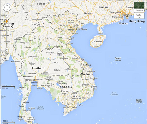
Japan in Northwest Thailand during World War II
| Preliminary notes on the IJA route
coming from the east to Bangkok bringing supplies for Burma and the invasion of India |
| Text | Notes | |||||||||||||||||||||||||||||||||||||||||||||||||||||||||||||||||||||||||||||||||||||||||||||||||||||
|
Three routes were utlimately designated. Eminating from the Royal State Railways of Siam (RSR) rail hub at Bangkok to:[0] 1. The Thai-Burmese Railway: connecting the RSR at Ban Pong Station and northwest to Thanbyuzayat Station on the Burma Railway (BR). 2. The Kra Isthmus Railway: connecting the RSR at Chumphon Station west to the port of Khao Fa Chi on the Kra River and north by boat along the Burmese coastal waterway to Ye, the southernmost BR station, or ports farther north along the railway, or to Rangoon itself. 3. The "Northern Route": connecting the RSR at Lampang with a road (now Thai Route 1) running north to the border crossing at Mai Sai-Tachileik , then (on current Burma Route 4) northwest to Kengtung and west to Meiktila Station on the Burma Railway. Even less well known is the route that brought supplies to the Bangkok rail hub.
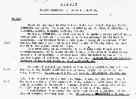
A prewar report on travel by rail from China to Malaya: Transcript There is organized traffic between China and Malaya through French Indochina and Siam. The route from Canton [Guangzhou, Kwangchow] is via Kwangsi [Guangxi], Kwang-Chu-Wan [Guangzhouwan, Kouang-Tcheou-Wan, Kwangchowan, Kwang-Chou-Wan], Haiphong, Saigon, Bangkok, Kantang, Penang. Travel in Indochina and Siam appears to be quite a simple undertaking, either with or without a passport; some 'palm-greasing' is all that is necessary. Any frontier station will issue a passport on payment of 200 ticals, but such a passport is not valid south of Penang; also, one must report to the policy every two days. When traveling it is advisable to be fairly well---though not too smartly-dressed, and to carry plenty of luggage in order to convey an impression of prosperity. A prosperous-looking traveller is accorded a greater degree of deference than is a poor one. Eastern Fleet Intelligence. Abstract of Energy Information No 7 - 20 Sept 41 Summary of itinerary:
Fort-Bayard (Tsamkong) [present day Zhanjiang][4] Guangzhouwan (also spelled Kouang-Tchéou-Wan, Kwangchowan or Kwang-Chou-Wan), meaning "Guangzhou Bay", was a small enclave on the southern coast of China ceded by Qing China to France as a leased territory and administered as an outlier of French Indochina.[1] The territory did not experience the rapid growth in population that other parts of coastal China experienced, rising from 189,000 in 1911[2] to just 209,000 in 1935.[3] Industries included shipping and coal mining. Japan occupied the territory in February 1943. The French briefly took it back in 1945 before returning it to China in 1946,[4] at which point its original name of Zhanjiang was restored. . . . Establishment of French rule and early development[edit] Fort-Bayard circa 1910 Kwangchowan was leased by China to France, according to the Treaty of 12 April 1898, on 27 May as Territoire de Kouang-Tchéou-Wan, to counter the growing commercial power of British Hong Kong.[5] Their colony was described as "commercially unimportant but strategically located"; most of France's energies went into their administration of French Indochina, and their main concern in China was the protection of Roman Catholic missionaries, rather than the promotion of trade.[1] Kwangchowan was effectively placed under the authority of the French Resident Superior in Tonkin (itself under the Governor General of French Indochina, also in Hanoi); the French Resident was represented locally by Administrators.[6] Kouang-Tchéou-Wan pavilion at the Marseille Colonial Exhibition Post and Telegraph building in Po Teou, Kouang-Tchéou-Wan. By 1931, the population of Kwangchowan had reached 206,000, giving the colony a population density of 245 persons per km²; virtually all were Chinese, and only 266 French citizens and four other Europeans were recorded as living there.[3] Industries included shipping and coal mining.[6] The port was also popular with smugglers; prior to the 1928 cancellation of the American ban on export of commercial airplanes, Kuangchowan was also used as a stop for Cantonese smugglers transporting military aircraft purchased in Manila to China,[8] and US records mention at least one drug smuggler who picked up opium and Chinese emigrants to be smuggled into the United States from there.[9] World War II[edit] After the fall of Paris in 1940, the Republic of China recognised the London-exiled Free French government as Kwanchowan's legitimate authority and established diplomatic relations with them; from June 1940 until February 1943, the colony remained under the administration of Free France.[4] This is an interesting fact bearing in mind that Kwangchowan had been governed from French Indochina, and that the authorities there were loyal to the Vichy Régime. The explanation may lie in the fact that Kwanchowan was totally surrounded by Free China and that the Japanese did not occupy that part of the China coast. Colonial militia with French officers. During the Japanese occupation of Hong Kong, Kwangchowan was often used as a stopover on an escape route for civilians fleeing Hong Kong and trying to make their way to Free China; Patrick Yu, a prominent trial lawyer, recalled in his memoirs how a Japanese civilian in Hong Kong helped him to escape in this way.[10] However, the escape route would not remain open for long; in collaboration with German-controlled Vichy France, which relinquished the concession to the Japanese-sponsored Chinese National Government (another claimant to the succession of the former Chinese Empire), the Imperial Japanese Army, would invade and occupy the area in February 1943.[4] Just prior to the Japanese surrender which ended World War II, the National Revolutionary Army, having recaptured Liuzhou, Guilin, and Taizhou, as well as Lashio and Mandalay in Burma, was planning to launch a large-scale assault on Kwangchowan; however, due to the end of the war, the assault never materialised.[11] The French lease over Guangzhouwan would soon be terminated regardless, under an agreement concluded on February 28, 1946. In exchange for a withdrawal of Chinese forces from northern Vietnam, the French not only returned Kwangchowan to the Nationalist government, but also gave up extraterritorial rights in Shanghai, Hankou, and Guangzhou, sold the Yunnan Rail Line to China, and agreed to provide special treatment for ethnic Chinese in Vietnam and Chinese goods exported to Vietnam.[12] After the handover, the Zhanjiang City Government was formally established to administer the city.
Đồng Đăng: In September 1940 a group of Japanese officers, in spite of an agreement signed the 22nd, attacked Đồng Đăng and laid siege toLam Sơn, beginning the Japanese invasion of French Indochina. NB: Aeronautical Chart 615 does not show a RR railhead at Pingsiang (Pingxiang) nor RR track anywhere nearby. Hence, the connection Chart 616 does show the Hanoi-Kunming RR. Refs from Wikipedia for Friendship Pass: 1. Vietnam 10 - Page 158 Nick Ray, Yu-Mei Balasingamchow, Iain Stewart - 2009 "border crossing: youyi guan–Huu nghi quan - The Friendship Pass at Dong Dang–Pingxiang is the most popular border crossing in the far north. The border post itself is at Huu Nghi Quan (Friendship Gate), 3km north of Dong Dang town; a xe om". 2. China's Southwest 3rd Edition - Page 485 Damian Harper - 2007 "As train tickets to China are expensive in Hanoi, some travellers buy a ticket to Dong Dang, walk across the border and then buy a train ticket on the Chinese side. This isn't the best way, because it's several kilometres from Dong Dang to Friendship Pass, and you'll have to hire someone to take you by motorbike. If you're going by train, it's best to buy a ticket from Hanoi to Pingxiang [N22°05.8 E106°45.0]," 3. Rough Guide to China - Page 20 David Leffman, Simon Lewis, Jeremy Atiyah - 2003 "Vietnam has three border crossings with China - Dong Dang, 60km northeast of Hanoi; Lao Cai, 150km northwest; and the little-used Mong Cai, 200km south of Nanning.
Vietnam Railway 1 the better known and now inoperative Kunming–Hai Phong Railway (aka Yunnan-Vietnam Railway (Chinese section = Kunming-Hekou Railway; Vietnamese section = Hanoi- Lào Cai Railway)) 2 a connection out of Haiphong crossing the border at Đồng Đăng ().Đồng Đăng station is marked on GE at N21°56.6 E106°41.8 Trying to trace connx north, the next large city appears to be Pingxiang (there are several places with this name: this is not one of the prominent ones). Wikipedia Guangxi Rail: The Hunan–Guangxi Railway (Xianggui Line), which bisects the autonomous region diagonally from Quanzhou in the northeast on the border with Hunan to Pingxiang in the southwest on the border with Vietnam, passes through Guangxi's three principal cities, Nanning, Liuzhou and Guilin. Most other railways in Guangxi are connected to the Xianggui Line. Saigon-Phnom Penh [Whyte, p 161] . . . French railway plans for Cambodia centred on a line from Saigon via Tay Ninh to Phnom Penh, envisaged as early as the 1880s, and continuing northwest past Battambang, to the Thai border, a distance of about 645 km. A longer term ambition was a subsequent branch to Kratie, possibly eventually extending into southern Laos. The alignment for the central section from Phnom Penh to Mongkol Borei was adopted in 1923. For the sections at either end of this, as with railway plans in Laos, the costs involved in build¬ing tracks and bridges over low-lying floodplains subject to frequent flooding and wide rivers which frequently changed course, were higher than the colony could bear. . . . . . . the Phnom Penh - Mongkol Borei section was . . . completed by the mid-1930s. After the section to Mongkol Borei was opened, the French appear to have completed some forma¬tion work for an extension west to Sisophon and Poipet by 1940, but it was only after the Thai annexation of the provinces of northwest Cambodia in May 1941 that rails were laid and connection made between the Cambodian and Thai lines. The Thais operated the line to the new Thai border with Japanese-occupied Cambodia at the Svay Daun Keo River. Passenger services from Bangkok to Battambang, stopping at selected stations, began in April 1942, although Japanese troops seem to have used the line during their invasion of Thailand on 8 December 1941. During the period of Thai annexation, all stations except Sisophon, Mongkol Borei and Battambang were renamed. Meanwhile the Japanese army had taken full control of the railway on the Indochinese side of the border about 1943. [Whyte, p 161] A Port Access Line of just over 7 km leaves the Poipet line 500m west of Phnom Penh station and heads north to the former Phnom Penh Port. It was built at the same time as the northern line (c.1929). . . . With no seaport of its own, Cambodia was reliant on shipping up the Mekong through Saigon to Phnom Penh port (connected by the Port Access rail line), as well as on overland transport of cargo to and from ports at Bangkok and Saigon. [Whyte, p 165] 1 Jul 1932 Phnom Penh - Pursat opened. 165.5 km
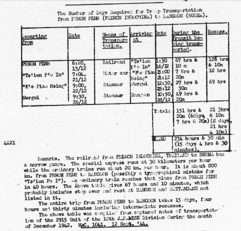
The following information was gleaned from a Japanese source dated December 1942. It documents the long:[5]
NB: there is an arithmetic error in the last cell of the table: 234 hours should read 364 hours. Transcript (numbers in parentheses are column numbers):
Remarks. The railroad from French Indochina, Thailand to Burma has a narrow gauge. The special express runs at 30 kilometers per hour while the ordinary trains run about 20 km per hour. It is about 800 km from Phnom Penh to Rangoon (possibly a typographical mistake for "Ts'ien Po I"). An ordinary train reaches that place from Phnom Penh in 40 hours. The above table gives 67 hours and 10 minutes, which probably includes stop over and rest at Bangkok and Battambang not listed in it. The entire trip from Phnom Penh to Rangoon takes 15 days, four hours and thrity minutes including intermediates recesses. The above table was compiled from captured notes of transportation of the 2915 Unit of the 18th Japanese Division during the month of December 1942 MAC. 1041. 12 Sept 44.
The above report is rather misleading, and appears to have been mishandled, but in retrospect it still contains useful information. The itinerary names three known locations, Phnom Penh, Mergui, and Rangoon. The inclusion of "steamer" transport on two legs of the itinerary and their durations suggests that the IJA were already using the future route of the Kra Railway from Chumphon to the future railhead at Khao Fa Chi adjacent to the Kra River, with coastal water craft making the connection to Rangoon. The distance from Phnom Penh to Rangoon is presented as about 800 km. By Google Earth's scale, the air-km distance is actually about 1,130 km (700 mi). The actual distance traveled on the ground would have been far greater. Railway: The travel ends at "Ts'ien P'o In" which is probably a casualty of Japanese transliteration of a Thai location name. Chumphon fits (see footnote 5). Phnom Penh - Thai-Cambodian border: 391 km[6] At an average "ordinary" speed of 20 km/hr, 1,120 km can be covered in 56 hours. That does not take into account any time lost for station stops, waiting, stopovers, transfers, refueling, whatever. With the same caveats, at an average "express" clip of 30 km/hr, the time required is 37 hours 20 minutes. On these bases, the 67 hours recorded seems plausible. Motor car: The location, "Ts'ien P'o In", is unknown, and is probably a casualty of Japanese transliteration of a Thai location name. Per Google Earth, the distance between Chumphon Rail Station and Khao Fa Chi is about 85 km on the Phetkasem Road (current Thai Route 4). The 7 hours 20 minutes recorded for traversing that distance results in an average speed of about 11.5 km/hr. December would have been in the dry season, so muddy roads should not have been a problem. The terrain is fairly flat. Maximum elevation was around 100 m. The duration seems plausible.[9] Steamer (1) Using a rough plotted course from Khao Fa Chi out the Kra River mouth and hugging the coast north to Mergui, the distance is about 376 km. With a recorded duration of 27 hours 30 minutes, the average speed would have been 13.7 km/hr (divide by 1.852 to get 7.4 knots). Steamer (2) Using a similarly plotted course from Mergui up the coast and crossing the mouth of the Sittaung River to Rangoon results in a distance of about 630 km. The recorded duration of this leg was 49 hours 20 minutes produces an average speed of 12.8 km/hr (6.9 knots). The speed on the two steamer legs are quite similar. The total distance traveled in kilometers was: Rail: 1,120 In the Remarks, aside from the peculiar 800 km distance between Phnom Penh and Rangoon, is the parenthetical statement "possibly a typographical mistake for 'Ts'ien Po I' ", referring to Rangoon. Coupled with the distance comments, the two suggest complete confusion (or ignorance) on the part of the analyst. The report has particular significance because it demonstrates that the IJA was using the Kra Isthmus land route connecting Chumphon Rail Station and the Kra Estuary before it was chosen as one of the three land connections to replace the sea route to Burma. The Kra Isthmus is an attractive and long-recognized crossing point: The narrowest part between the estuary of the Kra River and the bay of Sawi near the city Chumphon has a width of 44 km ( 27 mi), and has a maximum altitude of 75 m(246) above sea level.[9a] A canal through the Kra Isthmus, which would shorten shipping times around Asia, was suggested as early as 1677. . . . but . . . was discarded as impractical with the technology of the time. In the early 19th century, the British East India Company became interested in a canal. . . . in 1863 . . . an exploration was undertaken, again with negative result. In 1882, the constructor of the Suez canal . . . visited the area. In 1897, Thailand and the British empire agreed not to build a canal there, to protect the regional dominance of the harbour of Singapore.[9b] The land route was not new in 1942. In a journey from 1891 to 1896 that included that area, HW Smyth recorded:[10] In the first week in June we left Renawng (Ranong) for the unimportant division of Muang Kra, now more generally known as Pakchan [on the Kra River]. The Pakchan is a tidal estuary over fifty miels in length. It is navigable for craft drawing nine feet . . . For ocean-going ships very extensive dredging would be necessary . . . . In two marches we crossed to Champawn [Chumphon] . . . . It is unnecessary to describe the short journey across the isthmus, which has been already thoroughly investigated by those interested in the canal scheme. The watershed is low and the distance short, and modern engineers would doubtless find but little comparative difficulty in cutting through it; the scheme has fallen through for other reasons, probably not unconnected with politics. . . .
In December 1942, the only total land link between Bangkok and Burma that Japan used to supply its forces in Burma was via the RSR to Lampang where transport continued by road through Mai Sai-Tachileik and Kengtung to Miektila Rail Station on the Burma Railway (as described above).
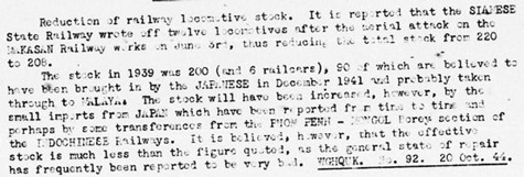
Transcript: Reduction of railway locomotive stock. It is reported that the Siamese State Railway wrote off twelve locomotives after the aerial attack on the Makasan Railway works on June 3rd, thus reducing the total stock from 220 to 208. The stock in 1939 was 200 (and 6 railcars), 09 of which are believed to have been brought in by the Japanese in December 1941 and probably taken through to Malaya. The stock will have been increased, however, by the small imports from Japan which have been reported from time to time and perhaps by some transferences from the Phnom Penh-Mongkol Borei section of the Indochinese Railways. It is believed, however, that the effective stock is much less than the figure quoted, as the general state of repair has frequently been reported to be very bad WGHQUK. No 92. 20 Oct 44
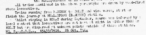
Transcript: All trains mentioned in the above paragraphs are driven by wood-fired steam locomotives. Trains running from Bangkok to Korat and vice versa, start or finish the journey at Hualanpong (Bangkok) station. Whilst staying in Korat during September, source was informed by a local contact that locomotives are not kept at night in either Ubon or Korat but are dispersed at unknown points outside of these stations. HQ SACSER, 65433/2616. 26 Oct 44.
Thai Burma Railway[Z] A railway route between Thailand and Burma had been surveyed by the British government of Burma at the beginning of the 20th century, but the proposed course of the line – through hilly jungle terrain divided by many rivers – was considered too difficult to complete. In 1942, Japanese forces invaded Burma from Thailand and seized the colony from British control. To maintain their forces in Burma, the Japanese were required to bring supplies and troops to Burma by sea, through the Strait of Malacca and the Andaman Sea. This route was vulnerable to attack by Allied submarines, and a different means of transport was needed. The obvious alternative was a railway. The Japanese forces started the project in June 1942.
|
[This is very much a working document]
0.^ Wisarut Bolsithi expanded these alternatives to seven: Origin of Death Railway, 2bangkokforum 1146 hrs 19 Sep 2005. The official Japanese military history cast it in a different light with the IJA concerned about relying on a single route, ie, the Thailand-Burma Railway; as a result, it considered two alternatives: the Kra Isthmus Railway or a road route. A decision was made to implement both. (Senshi Sosho, v 15, p 140). 1.^ "Terrain" map from Nations Online Project: Searchable Map and Satellite View of Vietnam using Google Earth Data. Annotations by author using Microsoft Publisher.
2.^ "French Indochina-Roads and Railroading", Road and Railroad Communications Report Asiatic Area: China, Burma, India for the Period 15-31 Oct 1944 JICA/CBI/SEA, p 31 (USAF Archive microfilm reel A8044 p0141).
3. Omitted.
4.^ Wikipedia: Guangzhouwan-+*/+
5.^ "Siam Roads and Railroads" in Road and Railroad Report for the month of Sep 1944 (Joint Intelligence Collection Agency, 1944), p 63 (USAF Archive microfilm reel A8044 p0075). Note that the information on IJA travel was dated Dec 1942, so it was apparently confiscated a year and a half later. The process of identifying "Ts'ien P'o In" and "K'e Piao Hsing" was as follows: Mergui and Rangoon were "knowns", so I rough plotted a course between the two as a path in Google Earth (GE); and then used GE's Show elevation profile to find the distance. With a recorded duration, I calculated the speed of the craft. I then used that speed to calculate a distance south from Mergui using the recorded duration. It ended around the mouth of the Kra River, which suggested the Kra Railway, but it hadn't been built yet. However, I assumed that current Route 4, then Phetkasem Road, had existed then, and provided a connection from the railroad on the east coast of the Kra Isthmus. That justified identifying "K'e Piao Hsing" as Khao Fa Chi. At Phetkasem Road's east end was Chumphon, which suggested that it was "Ts'ien P'o In". All of this suggests that the IJA's decision to establish the Kra Railway was based on long experience using Phetkasem Road.
6.^ Whyte, BR, The Railway Atlas of Thailand, Laos and Cambodia (Bangkok: White Lotus, 2010), pp 159-169. 7.^ ibid, pp 34-39. 8.^ ibid, pp 43-48.
9.^ This reconstruction relies heavily on descriptions in Boggett, David, 'Notes on the Thai-Burma Railway - Part IX: The Kra Isthmus Railway', Journal of Kyoto Seika University 2004, No 27, pp 26-45.
9a.^ Wikipedia: Kra Isthmus.
9b.^ Wikipedia: Thai Canal.
10.^ Smyth, HW, Five Years in Siam from 1891 to 1896 (London: John Murray, 1898), (republished by Elibron Classics, 2005), pp 30-32.
Z.^ Wikipedia: Burma Railway.
| |||||||||||||||||||||||||||||||||||||||||||||||||||||||||||||||||||||||||||||||||||||||||||||||||||||