Japan in Northwest Thailand during World War II
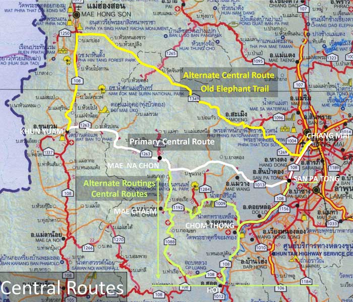
CENTRAL ROUTES[1]
(Primary Central Route is marked in white)

|
TABLE OF CONTENTS
|
|||||
| Main Central Route: Khun Yuam - Mae Na Chon - Mae Wang - Ban Kat - San Pa Tong - Chiang Mai |
|||||
| Accum Km |
Route |
Station |
Description |
||
| ----- | ---- | General | |||
| (000) | 1263 | 000 | Khun Yuam | ||
| (068) | 1263 | 068[2] | Mae Na Chon | ||
| (068) | 1088 | xxx[2] | Mae Na Chon | ||
| (072) | 1088 | xxx[2] | Turn off to east on unnumbered route | ||
| (072) | 0000 | xxx[2] | Start unnumbered road to east | ||
| (098) | 0000[2] | xxx[2] | Small unnamed[2] damsite | ||
| (115) | 0000 ---- |
xxx[2] --- |
End easterly unnumbered road at T-intersection; Stem of T is unnumbered road S/SE to Santi Suk on Route 108 |
||
| (115) | 1013 | xxx[2] | Westerly end of Route 1013 (?) | ||
| (117) | 1013 | xxx[2] | Mae Win | ||
| (129) | 1013 | xxx[2] | Mae Wong | ||
| (134) | 1013 | 009 | Ban Kat | ||
| (143) | 1013 | 000 | San Pa Tong | ||
| (143) | 0108a | 143 | San Pa Tong | ||
| (153) | 0108a | 153 | Hang Dong | ||
| (163) | 0108a | 163 | Beginning Route 108 (Sta 000) at intersection with Route 1141 | ||
| (163) | 0000 | 163 | Unnumbered road (Thipanet Road) | ||
| (165) | 0000 | 165 | Wat Muen San | ||
| Alternate Routings for the Central Route | |||||
| --- | General | ||||
| Alternate Central Route: The Old Elephant Trail | |||||
| --- | General | ||||
NOTES
1.^ Map is extracted from แผนที่ทางหลวงประเทสไทย Scale: 1:1,600,000 (กรุงเทพมหานคร:กรมทางหลวง, 2009) [Road Map of Thailand, Scale 1:1,600,000 (Bangkok: Department of Public Highways, 2009)] (foldout map). Annotations are by author. Routes used by retreating IJA forces are here assumed to approximate currently existing roads.
2.^ Number needs field verification.
| First published on Internet | ||
1 |
2012 Jun 10 |
Enlarged table of contents listings |
