Japan in Northwest Thailand during World War II
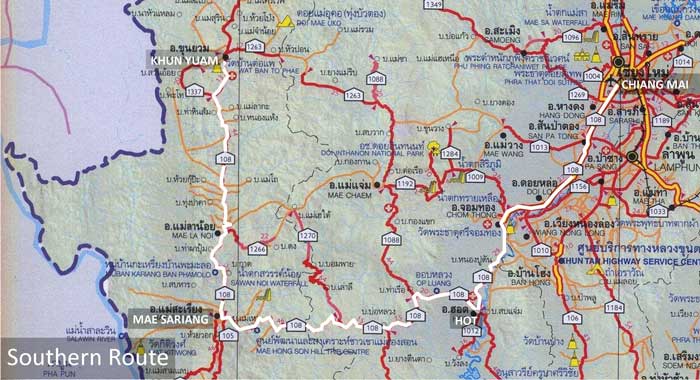
SOUTHERN ROUTE[1]
(route traced in white)
|
TABLE OF CONTENTS
|
|||||
| Accum Km |
Route |
Station |
Description |
||
| ----- | --- | General | |||
| (000) | 0108b | 198 | Museum | ||
| (000) | 0108b | 198 | Wat Muai To | ||
| (000) | 0108b | 198 | Khun Yuam | ||
| (001) | 0108b | 197 | Khun Yuam airstrip | ||
| (010) | 0108b | 188 | Muang Pon | ||
| (045) | 0108b | 153 | Mae La Luang | ||
| (094) | 0108b | 104+ | Mae Sariang airport | ||
| (094) | 0108b | 104 | Mae Sariang | ||
| (159) | 0108b | 039 | Bo Luang | ||
| (198) | 0108b | 000 | Hot | ||
| (198) | 0108a | 088 | Hot | ||
| (286) | 0108a | 000 | Chiang Mai | ||
| (286) | 0000 | 000 | Chiang Mai (Thipanet Road) | ||
| (288) | 0000 | 002 | Wat Muen San | ||
NOTES
1.^ Map is extracted from แผนที่ทางหลวงประเทสไทย Scale: 1:1,600,000 (กรุงเทพมหานคร:กรมทางหลวง, 2009) [Road Map of Thailand, Scale 1:1,600,000 (Bangkok: Department of Public Highways, 2009)], a foldout map. Annotations are by author. Routes used by retreating IJA forces are here assumed to approximate currently existing roads; though most notably, the area around Hot (at the SE corner of the route) has been altered by a reservoir which has flooded what was the town center during WWII.
| First published on Internet | ||
1 |
2012 May 30 |
Enlarged table of contents listings |