| N18°04.168 E97°40.954 | Tha Ta Fang: Old Station House (Th: โรงพักเก่าบ้านท่าตาฝั่ง / Jp: ターターファン古い駅舎) page 2 of 2 |
off Route 4055 Station 000 |
| Text | Notes | |||||||||
|
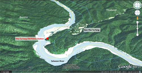
Additional relevant maps An oblique view by Google Earth looking north at the site emphasizes its relative isolation:[10]
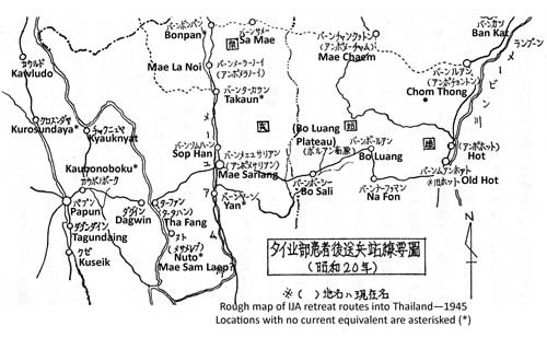
Map by IJA Veterans of WWII routes in Northern Thailand: extract covers generally the same area as the first map on page 1, but in more detail:[11]
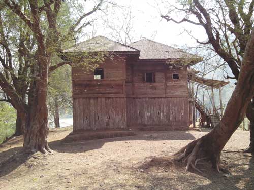
Additional photos A view from the side which tends to emphasize the 'blockhouse' aspect of the structure:[12]
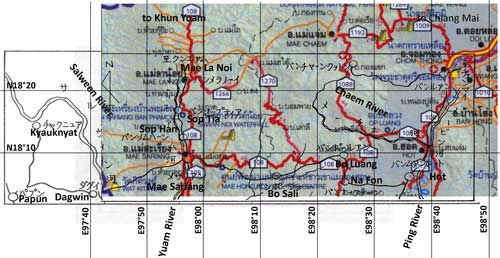
Additional text Account of IJA Veterans searching the Tha Ta Fang area for remains of WWII casualties[13] The Riverbank Team, including Area Commander Ashina, Group Leader Yoshino and Member Kanda, moved out. There may have been a separate interest in going to the border which was formed by the Salween at this point; and it can also be judged as an extra "benefit" [an improved probability of finding remains]. But that line of thought did not enter into the decision to go to the Salween. Early next morning, the Riverbank Team jeeped down the riverbed road. In three hours, they reached Mae Sam Laep on the Salween. The investigation division had only investigated this one spot on the Salween. Group Leader Yoshino recorded: From here, forty minutes upstream in a boat with an outboard motor, and we were in Ban [Tha] Ta Fang. On the opposite bank is Dagwin, Burma. Traveling on to Papun would have taken about more one day. In Ban [Tha] Ta Fang there is a police sub-station, just as there was during the war. Three households with 24 people currently reside there. Our main guide had to be hospitalized for malaria in a hospital on the Burma side of the Salween. Unfortunately, only he knew where the two graves were. From here, 2 km west of the village of Ban Chou , a mountain tribe village of 15 households, it was a two day journey to Chiang Mai and there are no villages in between. It was said by residents in Ban Chou Village that there was a grave site 15 km away. It wasn't practical to follow that up, so, facing the direction of that location, we pressed our hands together in memory of those who might be out there, and abandoned Ban [Tha] Ta Fang. Because of the poor condition of the truck, we overnighted in Mae Sam Laep. Rough translation of Daily News article about the Tha Ta Fang Station[14] Tha Ta Fang's 111-year-old wooden border station may be restored as a tourist attraction. Already registered as a historic site, efforts will be required to maintain it for future generations to enjoy. It functioned as a police station on the Thai-Burma border, keeping the Salween River secure. Tourists already frequent the site on a regular basis. . . . Located on a cliff along the Salween River . . . registered as a historic site by the Office of the National Museum of Archaeology . . . . During WWII, the station chief was a sergeant. . . . The building is constructed of heavy wood, which is deteriorating. . . . The sides of the station had gun ports on both floors. In 1981, the police office was moved from the old station building to a new building at Tha Ta Fang. . . . The building has played a significant role in Thailand's history and should be preserved. . . . Derivation of current place names from those in katakana on IJA Veterans' maps Certain place names in katakana on IJA Veterans' sketch maps are difficult to correlate with place names on current maps. The veterans apparently used maps from WWII and those current in the 1970s to assemble the sketch maps used in their search for remains; but in addition they did not hesitate to grab place names as used 'on the ground' by locals in an attempt to better locate certain points. To assist in correlating those names rendered in Japanese with current location names, a veterans' map was overlaid on a current national highway map of the area:[15]
The map sketch was intended only to provide general details, so it has no scale, nor even a consistent scale across the whole drawing. As a result, it was stretched to partially fit the scale map (in color) beneath. Results, proceeding from left: チヤクニユア (CHIYAKUNIYUA) [current place name determined from approximate location on the west bank of the Salween] ダグイン (DAGUIN) バンツプテイア (Ban TSUPUTEIA) バンソムハーン (Ban SOMUHAN) バンボーシー (Ban BO SHI) [tambon in Amphur Hot] バンナーフヲーン (Ban NA FUON) バンチヤーソクヲトン (Ban CHIYA SOKUOTON) [the map locates the place on the Chaem River at a road leading to 'Ban Luang', aka Chom Thong; that junction would point to the Mae Chaem area. Only a very rough approximation of the katakana was found in the Mae Chaem area. This conclusion is generally confirmed by another map in the veterans' book, p 421.] バンポールアン (Ban PO RUAN) バンルアン (Ban RUAN) [Ban LUANG: a tambon in Amphur Chom Thong]
NOTE: Article should be revised after Southern Route is presented.
|
10.^ Google Earth, accessed 22 Apr 2013. Annotations by author using Microsoft Publisher.
11.^ Journal on War Dead, p 421. Transliteration by Yoshio Fukuda.
12.^IMG_20130310_152107, 10 Mar 2013. Front of the building is to the right.
13.^ Journal on War Dead, p 458. Translation by Josh Skiles.
14.^. Daily News, ibid. Translation by google translate.
15.^ This map was made by superimposing the first map on the previous page on an extract from แผนที่ทางหลวงประเทสไทย Scale: 1:1,600,000 (กรุงเทพมหานคร:กรมทางหลวง, 2009) [Road Map of Thailand, Scale 1:1,600,000 (Bangkok: Department of Public Highways, 2009)] (folded map). It should be noted that listeners with ears tuned to Japanese or English languages "hear" Thai words completely differently from each other --- as well as completely differently from what Thais hear. And neither English nor Japanese language alphabets are designed for accurately recording Thai language sounds. So, when those foreign listeners transliterate what they think they hear into what they believe is a proper rendering in Japanese and English written text, the end results can be very different; and extremely difficult to correlate. The problem is made more difficult because different Thai individuals from within a relatively close distance of a particular place may either pronounce its name quite differently or actually use different names to identify that same place. Further, some place names used locally are simply not recorded on maps. Finally, all Royal Thai Survey Maps carry the warning, "There are numerous identically named villages portrayed on this map". And that warning applies equally to place names on different maps. |
|||||||||


