Lanna-ww2

Northwest Thailand during World War II

Details of Aircraft Losses by Date


Text Notes
 

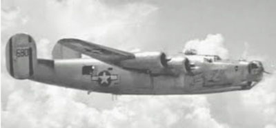
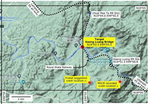
21 Nov 1944: on this date, an Allied B-24J heavy bomber was shot down while attacking the Kaeng Luang Railway Bridge over the Yom River in Phrae Province located between Lampang and Uttaradit in northern Thailand.[1]

B-24J

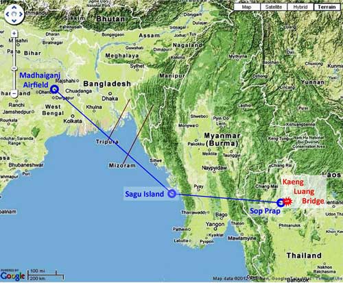
The plane, one of twelve in this mission by the 492nd Bomb Squadron homebased in Madhaiganj Army Air Base, India, passed over Sagu Island, Burma; then Sop Prap, Thailand; to arrive finally at Kaeng Luang:[2]

Flight_plan

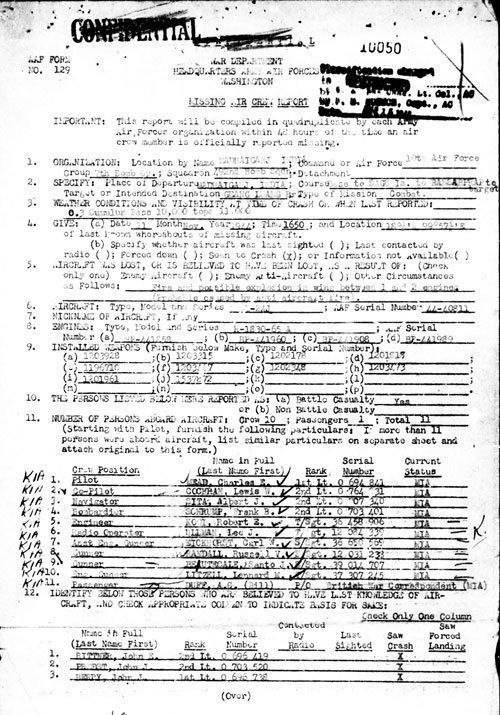
The bridge was targeted as part of a strategy to stop supplies destined for the IJA in Burma which were moving by rail from Bangkok to Lampang where they were then transferred to trucks for traveling north on the Phahonyathin Road to Mae Sai and on into Burma. There were two major railway bridges on that route: one of 263 m at Ban Dara and a 174 m bridge at Kuang Luang.[3] Both were under regular attack in an era when "pin point" bombing accuracy did not exist; in an attempt to compensate for that inaacuracy, bombers were dropping to 300 feet (100 m) altitude to deliver bomb loads and still having difficulty knocking out targets --- not only bridges, but also railway stations, marshalling yards, tunnels, etc.

But aircraft at that low altitude were extremely vulnerable to enemy ground fire and that's what brought down Mead's B-24. Missing Air Crew Report (MACR) 10050 recorded the details:[4]

MACR 2

Key information:

• Organization: 10th Air Force, 7th Bomber Group, 492nd
  Bomber Squadron
• Place of Departure: MADHAIGANJ, INDIA
• Course: Base to SAGU Island to BANSABPRAP to target
• Target: GEANG LUANG [Kaeng Luang] Bridge
• Date/time of loss: 21 Nov 1944 16:45 hrs
• Loss result of: Fire and possible explosion in wing between
  engines 1 and 2 (probably caused by anti-aircraft fire).
• Location where lost: 18°¼'N 99°57½'E [N18°00.25 E99°57.50]
• Aircraft Type: B-24J; Serial No. 44-40811

Crew Members
Position
Name
Rank
Pilot
MEAD, Charles E
1st Lt
Co-Pilot
COCHRAN, Lewis W
2nd Lt
Navigator
SITA, Albert J
2nd Lt
Bombardier
SCHRUMP, Frank B
2nd Lt
Engineer
KOOI, Robert E
T/Sgt
Radio Operator
ULLMAN, Lee J
T/Sgt
Asst Eng Gunner
EICKHORST, Carl W
S/Sgt
Gunner
RANDALL, Russell V
S/Sgt
Gunner
BEAUTECALE, Santo J
S/Sgt
Eng Gunner
LITZELL, Lennard M
T/Sgt
Passenger
DUFF, AG (Bill)
P/O


"AG" Duff was actually "WG" Duff, as in William George Duff. He was a British war correspondent; and "P/O" was an abbreviation for "press officer".[4a]

[Witnesses]

BERRY, John J, 1st Lt
BITTNER, John E, 2nd Lt
PROBST, John J, 2nd Lt

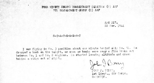
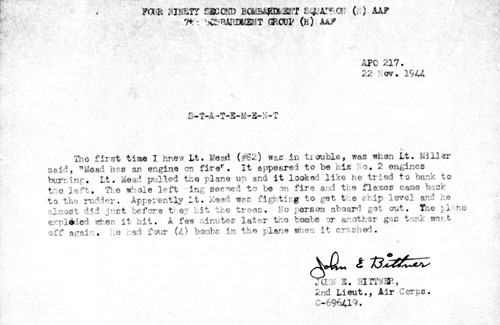
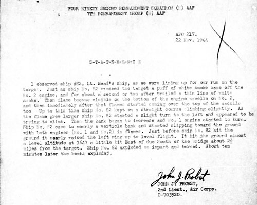
Witness statements:

• Statement by John J Berry, 1st Lt:

MACR-4

Transcript:
I was flying in No 3 position about one minute behind ship No 82. He dropped a bomb on the target, as soon as bombs were away a fire broke out between No 1 and No 2 engines. He started losing altitude and crashed behind a ridge out of sight.


• Statement by John E Bittner, 2nd Lt:

MACR-5

Transcript:
The first time I knew Lt Mead (#82) was in trouble, was when Lt Miller said, "Mead has an engine on fire". It appeared to be his No 2 engine burning. Lt Mead pulled the plane up and it looked like he tried to bank to the left. The whole left wing seemed to be on fire and flames came back to the rudder. Apparently Lt Mead was fighting to get the ship level and he almost did just before they hit the trees. No person aboard got out. The plane exploded when it hit. A few minutes later the bombs or another gas tank went off again. He had four (4) bombs in the plane when it crashed.


• Statement of John J Probst, 2nd Lt:

MACR-6

Transcript:
I observed ship #82, Lt Mead's ship, as we were lining up for our run on the target. Just as ship No 82 crossed the target, a puff of white smoke came off the No 2 engine, and for about a second or two after, trailed a thin line of white smoke. Then flame became visible on the bottom of the engine nacelle too. Up to this time ship No 82 kept on a straight course climbing slightly. As the flame grew larger, ship No 82 started a slight turn to the left and appeared to be trying to climb. Then the bank began to increase and No 1 engine started to burn. Ship No 82 came to nearly a vertical bank and started slipping toward the ground with both engines (No 1 and No 2) in flames. Just before ship No 82 hit the ground, it nearly raised the left wing up to level flight. It hit the ground almost a level attitude at 1647 a little bit east of due south of the bridge, about 2-1/2 miles from the target. Ship No 82 exploded on impact and burned. About ten minutes later the bombs exploded.


The MACR provided a map of the immediate area of the bridge:

MACR-8


A close up of the map above:

MACR map


A Google Map extract below of the same general area highlights the improvement in mapmaking and reproduction over 70+ years. Actually the MACR map is quite good considering it was probably sketched in on a mimeograph master which was then put through a typewriter in two different directions.[5]

MACR map compare


And trying to relate the aerial photo of the bridge area below to features on the ground must have been a challenge:

MACR-9

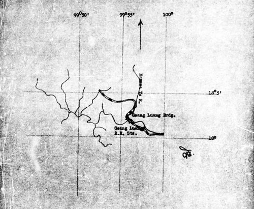
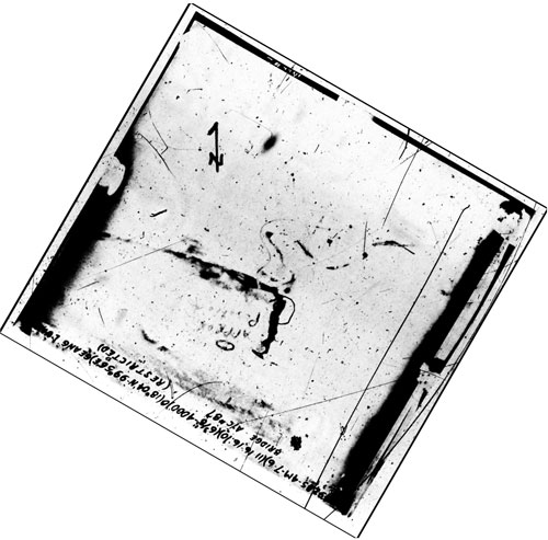
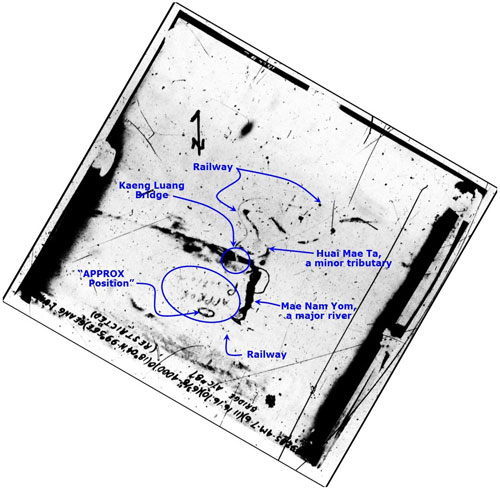
A careful examination of the details might find the content foreshortened roughly north to south, indicating the photo to be an obligue view and resulting in this interpretation:[6]

MACR 09 ano

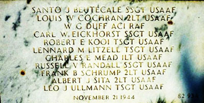
The "APPROX Position" is the location of the crash. Coordinates for that position in the photo are about N18°01.9 E99°55.3. The location specified in the MACR text is N18°00.25 E99°57.50, about 5.5 km away to the SE. The statement by Probst places the crash site just east of about 2½ miles south of the target. This would probably be the most useful in locating the crash site today in that the position coordinates in the MACR use a datum differing from the currently used WGS84; and the poor quality of the aerial photo makes any interpretation questionable. As emphasized with capital letters in the photo, the position is approximate. In either case, the locations imply the attack came in from the north of the bridge.

After the war, with this information and probably local assistance, an American Graves Registration Service team was successful in locating the remains of the crew and its passenger. They were interred in a collective grave at Jefferson Barracks National Cemetery, Lemay, St. Louis County, Missouri, USA, per this memorial plaque:[7]
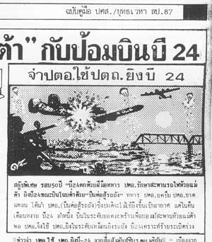
Epitaph stone


The crew was recorded in this undated photo:[8]

Mead-crew


In Thailand, the shootdown was celebrated as a rare victory against a vastly superior enemy. Sak Rattanachai, unofficial historian for Lampang, generated this brief report:[9]

Sak_R_on_Mead

Translation:[10]

Sergeant uses anti-tank cannon to shoot down a B-24

A B-24 was shot down by a sergeant in an anti-aircraft unit protecting Mae Ta Railway Bridge.

With a severe shortage of such equipment as anti-aircraft guns, the sergeant had an anti-tank cannon to set up at the site. One moonlit night a B-24 approached the bridge at very low altitude --- flying just above the treetops --- apparently with the intent of bombing the bridge. The B-24 was well within the elevation of fire of the anti-tank gun, and the sergeant shot the plane down.

Comment: Note that the shooter is not identified by name.


• Umemoto, 2002:[11]

Entry for Mead (Umemoto, v 2, p 523, line 10)
Item
Japanese
English translation
Date
昭和19年11月21日
  21 Nov 1944
Unit
492BS
  492nd Heavy Bomb Squadron
Casualty
B-24J
  B-24J Heavy Bomber
Pilot
チャールズ•ミード中尉
  Lt Charles Meade
Location
ギアラム橋梁
  [Kuang Luang] Bridge
Shooter
対空砲火
  Anti-aircraft fire
Details
11名戦死
 11 killed in action


Umemoto comment:[12]

11月21日、ギアラム橋梁を攻擊した第492爆撃飛行隊のB24、12機のうち1機、たまたま英国の戦時特派員を同乘させていたチャールズ• ミード中尉機は対空砲火で、まず2番エンジンが発火、炎は左翼に回り、方向舵付近まで燃え広がり、高度を失つて行つた。操縦者は機体を水平に保とうと努カしていたが、遂に立木に衝突、爆発、搭乗していた11名全員が戦死した。

On November 21, one of twelve B24s of the 492nd Bomb Squadron, piloted by Charles Meade, attacked the [Kaeng Luang] Bridge. On the plane was a British wartime correspondent. Anti-aircraft fire hit an engine on the left wing. It ignited and the entire wing became engulfed in flame which spread towards the rudder. The pilot tried to keep the aircraft horizontal as it was losing altitude, but as it crashed into the forest, it exploded, killing all 11 people on board.[13]


Revision List
Rev
Date
Description
0
2021 Dec 31
First published on Internet


References are provided in this column for the convenience of the reader. Please advise author of any errors.

These pages were composed to be viewed best with Google Chrome.

This webpage expands on Kaeng Luang Bridge, Phrae Province, elsewhere on this website.

1.^ Railway stationing for bridge: 546+94 (BR Whyte, The Railway Atlas of Thailand, Laos and Cambodia (Bangkok: White Lotus, 2010), p 28)

Photo: Pacific Wrecks, B-24J-175 "Lonesome Lady"
44-40680 in flight
Credit: USAAF Date: 1945 B&W

2.^ "Terrain" map from Nations Online Project: Searchable Map and Satellite View of Thailand using Google Earth Data. Annotations by author using Microsoft Publisher.

The flight plan is set out in the Missing Air Crew Report (MACR) 10050, copied here.

Madhaiganj Airfield:
N23°39.14 E87°20.70
Sagu Island: N18°48 E93°58
Sop Prap: N17°53.5 E99°13.13

Sagu Island is identified under "Course" in the MACR (p 1).

"BanSabprap" in USAAF context probably refers to a peak in the prominent mountain ridge (53 air-km SSW of Lampang) directly west of modern day (Ban) Sop Prap, which is located in the Wang River valley about 40 air-km downstream of Lampang.

3.^ Railway bridge data from BR Whyte, ibid, pp 27
& 28.

4.^ MACR 10050 provided by Mike Stowe, email of 20:41 30 Nov 2012, accireport@comcast.net


4a.^ Name correction per Jefferson Barracks National Cemetery Memorials. Function from MACR, Item 11.


f


5.^ The map is an extract from Google Maps, annotated by author using Microsoft Publisher.


6.^MACR page 9 annotated by author using Microsoft Publisher.


7.^ Jefferson Barracks National Cemetery Memorials.


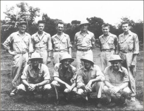
8.^ Photo of crew from 7thBGHF. Downloaded 13 Dec 2012. Link no longer active. Crew names were captioned with the proviso "order unknown".


9.^ รัตนชัย, สักดิ์, ปาะวัติศาสต์ศึกษายุทธเวหาลำปาง [Rattanachai, Saksern S, Japan in Lampang during World War II (Lampang: (self-published), undated)] Ch 70, p 114.

In an alternate account, Young, Edward M, in B-24 Liberator Units of the CBI (Oxford: Osprey Combat Aircraft-87, 2011), p 37, states that Japanese machine gunners brought down Mead's plane. Source: Google preview., accessed 2014: URL link no longer functional.

While the use of an anti-tank gun for anti-aircraft duty seems innovative, note that the IJA Model 98 20mm (p 217), the Model 96 Type 2 25mm (p 230), and the 40mm single and dual mounted (p 230) automatic cannons were all titled "antiaircraft antitank", per Chapter 9, TM-E 30-480 Handbook on Japanese Military Forces (Washington: War Department, 1944).

With regard to moon light, the plane was shot down at about 1645 and the sun was still well above the horizon.

The remoteness of the Kaeng Luang Bridge for its defenders is captured on Rotfaithai.com, particularly photo. The bridge is better known locally as Huai Mae Ta Bridge since it spans the Huai Mae Ta and the closest station carries the same name, at railway stationing 546+94 (per Wisarut Bholsithi email of 12:50 29 Apr 2013).

10.^ Translation by Chanagun Chitmanat, 2008.

11.^ 梅本弘 [Umemoto, Hiroshi], ビルマ航空戦・上
[Air War in Burma, Vol 2] (Tokyo: Dai Nippon, 2002)],
p 523, line 10.

12.^ Umemoto, ibid, pp 327-328.

13.^ Japanese translations by Google Translate; edited by author.