| Uttaradit Area Air Facilities Review (page 1 of 2) |
| Text | Notes | ||||||||||||||||||||||||||||||||||||||||||||||||||
|
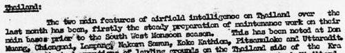
Existing records of the development of air facilities in the Uttaradit area provide a confusing picture. The following reviews the subject chronologically. Significant other events are included in brackets.
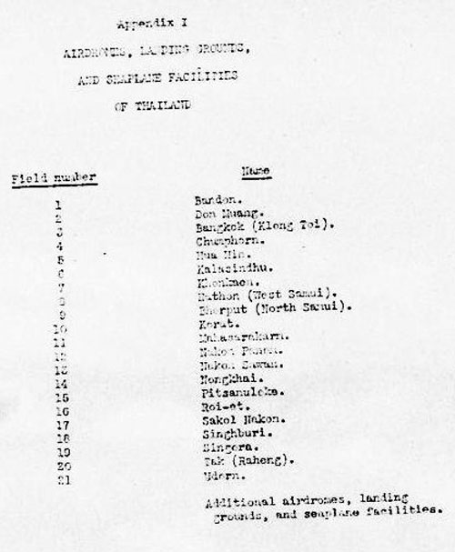
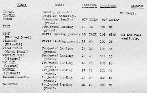
And note that it also did not include Lampang or Chiang Mai. Uttaradit was included in a supplemental listing of "Additional airdromes, landing grounds, and seaplane facilities (correct up to April, 1940)"[3] as a "civil landing ground":
Transcription, key item:
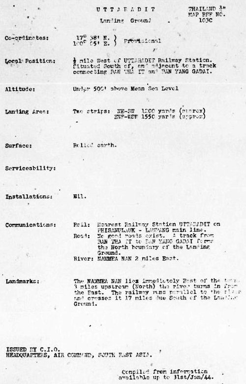
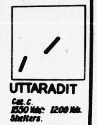
And both Lampang and Chiang Mai were also included in this listing. It is also notable that, amongst the 21 air facilities judged significant, only one was classified as "military": Don Muang; while ten more classified as "military" were included in the second, "Additional", list. January 1944: Airfield Schedule for Uttaradit Landing Ground shows two airstrips listed for the first time:[4]
Transcription:
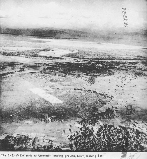
The "Cat C" indicates "liable to become unserviceable after rains". A 24 Jan 1944 aerial photo of the Uttaradit area shows the two runways. Photo has been rotated so that north is page-up according to north arrow next to the title block on the image.[6]
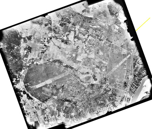
The aerial view, printed in a contemporary Airfield Report, is probably based on a series of aerial photos, just two of which are stitched together below to show the proximity of the two airstrips in greater detail:[6a]
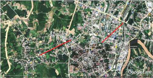
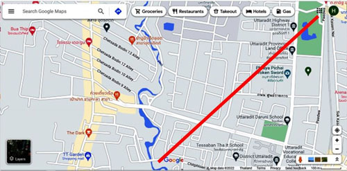
A full size image of the above displaying the much greater detail that aerial photo interpreters had access to is available here (a large file, 5MB, which can be viewed up to 500% enlargement). A present day Google Earth view shows the location of the two WWII airstrips in Uttaradit, marked in red.[7]
The following data were derived by applying Google Earth Path and Ruler tools to the map above:
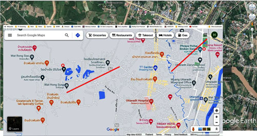
To better locate the two old runways on current day features, a Google Maps view of the Uttaradit area was overlaid on the Google Earth view, again with runways marked in red:[8]
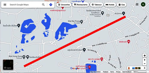
The Google Map view was then divided between the two runways which allowed an enlargement of surrounding features. The two maps directly below are matched in scale, and, as shown, the southwesterly runway was wider than the northeasterly one. Unfortunately Google Maps does not name most of the streets intersected by the runways. Northeast runway shown in red on Google Map:[9]
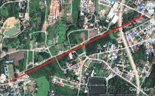
No present-day evidence of this runway is believed to have survived on the ground. Southwest runway shown in red on Google Map:[10]
Note that the runway symbol above hides a road which, for the most part, may have followed the original runway:[10a]
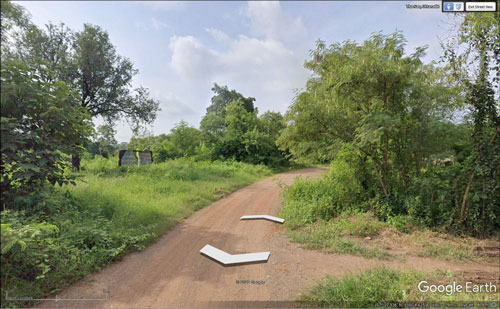
It is of dirt and of insufficient importance for Google Earth / Maps to offer a Street View for most of its length: what does show is a poorly maintained gravel roadbed:[10b]
April 1944: Airfield Report No. 21 of April 1944 included a brief status on Uttaradit:[10c]
Transcription:
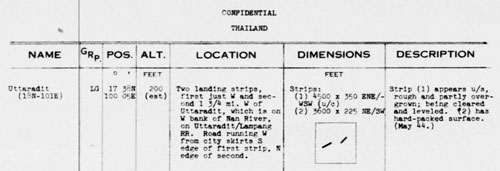
25 July 1944: From Provisional Airfield List, Southeast Asia, Enemy Airfield Information Report No. 3, 25 Jul 1944, Thailand, p 70:[11]
Transcription:
In this schedule only, runway numbering was reversed; ie, "Dimensions" should have read:
In other words, Runway 1, the older runway, is the more easterly of the two.
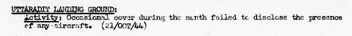
[06 Oct 1944: serious attack on Uttaradit Railway Station resulted in much damage in the station area and loss of one RAF Liberator[12b]] 21 Oct 1944: Description of Uttaradit air facilities (and typical hereafter to the end of the war) [13]
Transcription:
November 1944: Uttaradit had been judged significant in the April 1944 status report (above), and regardless of the null aircraft traffic there in October, a photo of the southwest runway appeared on the cover of the November 1944 issue of Airfield Report No 28.[14]
Of more interest is an enlargement of the cover photo, with this caption:[15]
The other runway, Runway 1, is out of view to the left of this photo. The November 1944 Airfield Schedule for Uttaradit Landing Ground[16] repeated the information in the January 1944 Schedule, with the following changes / additions:
[16 Nov 1944: Allies bombed Pak Nam Pho Railway Station.[16a]] 19 Apr 1945: This is the last status entry for Uttaradit Landing Ground:[17]
Transcription:
|
References are provided in this column for the convenience of the reader. Please advise author of any errors. These pages were composed to be viewed best with Google Chrome. 0.^ BR Whyte, The Railway Atlas of Thailand, Laos and Cambodia (Bangkok: White Lotus Press, 2010), 00.^ Ibid. 1.^ Air Force Historical Research Agency (AFHRA) Reel B1750, p1716, Survey of Thailand (Washington: US War Department, 15 Mar 1941), Appendix I, page (unnumbered). 2.^ ibid, p 1767.
3.^ ibid, p 1813.
4.^ AFHRA Reel, A8055 p0399, Airfield Report No 18, (Jan 1944), p (unnumbered) The title for this format eventually evolved to "Airfield Schedule". Ban Tha It and Ban Yang Gadai, used in the road description, could not be found; however, that road was said to form the north boundary of the landing ground, and could be present day Thai Intra-Province Route 1041 (see Wikipedia: Thai Highway Network, Highway Numbering).
4a.^ AFHRA Reel, A8055 p0428, Airfield Report No 18, (Jan 1944), p (unnumbered): CIO (C.I.O.): Chief Intelligence Officer
5.^ AFHRA Reel A8055 p0423. Airfield Report No 18, (Jan 1944), p (unnumbered).
6.^ AFHRA Reel A8055 p0565. Airfield Report No 18, (Jan 1944), p (unnumbered). Better copy provided by Sakpinit Promthep, email 12:14 04 May 2022.
6a.^ US National Archives, Film Can B7348 (30 Nov 1944) Mission 35PR/4MG49, Frames RV44 & RV46, obtained and processed by Matt Poole. Stitched with Microsoft Image Composite Editor (ICE), ver 2.
7.^ Google Earth view of Uttaradit, marked up by author using Microsoft Publisher.
8.^ Google Map view of Uttaradit, superimposed on Google Earth view, using Microsoft Publisher, by author.
9.^ Enlargement covering only the northeast runway in the marked up Microsoft Map image above.
10.^ Enlargement covering only the southwest runway in the marked up Microsoft Map image above.
10a.^ Close-up of southwest runway on Google Earth. Markup by author using Microsoft Publisher.
10b.^ Street view in Google Earth of section of roadway on or adjacent to the probable location of the southwest runway.
10c.^ AFHRA Reel A8055, p0679, Airfield Report No 21 (Apr 1944), p 3
11.^ AFHRA Reel A1284, p1349, Provisional Airfield List: Southeast Asia (25 Jul 44), p 70
12.^ (need reference) A similar cleared area is faintly visible to the east of the Chiang Mai airstrip in Photomosaic No. 1 (03 April 1944). While the established runway there is on heading 18-36, the cleared area is at 16-34. 12a.^ Wisarut Bolsithi in 2bangkok blog on Thai history, 0302 30 Oct 2008. Copied 18 Mar 2010 (no longer on-line). 12b.^ Ibid. 13.^ AFHRA Reel A8055, p1020, Airfield Report No 27 (Oct 1944), p 10.
14.^ AFHRA Reel A8055, p1059, Airfield Report No 28 (Nov 1944), cover page.
15.^ Enhanced copy of photo in cover provided by Sakpinit Promthep email of 05:14 04 May 2022, attachment: Uttaradit LG-2.jpg
16.^ AFHRA Reel A8055, p1069, Airfield Report No 28 (Nov 1944), p (unnumbered)
16a.^ Wisarut Bolsithi, ibid. 17.^ AFHRA Reel A8056, p0166, Airfield Report No 33 (Apr 1945), p (3)
|
||||||||||||||||||||||||||||||||||||||||||||||||||
-true-N.jpg)
-AF-Rpt-Nov-1944-cover.jpg)