Japan in Northwest Thailand during World War II
|
Map Resources |
| Text | Notes | ||||||||||||||||||||||||||||||||||||||||||||||||||||||||||||||||||||||||||||||||||||||||||||||||||||||||||||||||||||||||||||||||||||||||
|
These pages on maps are in process --- not complete. Maps Perry-Castañeda Library Map Collection The primary on-line source for maps showing the Allied perspective of Southeast Asia in general, and particularly of northwest Thailand, is the Perry-Castañeda Library Map Collection at the University of Texas in Austin. It offers the following : US ARMY MAPS GREAT BRITAIN WAR OFFICE: BURMA, THAILAND MAP Note that, but for the last map, all are post-war. Some period maps are available in the USAF Archives; they are not on-line, but are available as microfilm copies via CDs at a nominal price. Being microfilm, they cannot match the quality of the Perry-Castañeda Collection, but they do provide at least a perspective on the information which was used in decision-making by Allied commands during WWII.
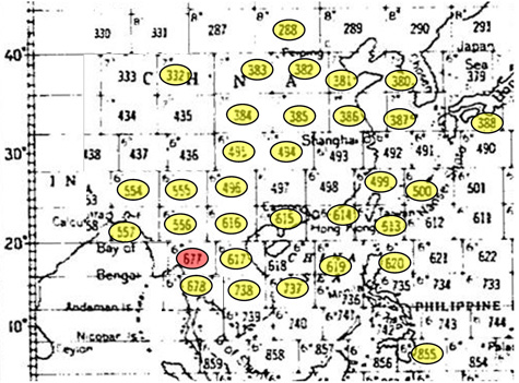
Maps / charts in the USAF Archives (AFHRA, or Air Force Historical Research Agency) include: Aeronautical Charts.[0] USAF Archives have made available some maps via microfilm rolls, specifically 25866, pp 0381-0506, titled "Aeronautical Maps of China", and 25882, pp 0956-1024, titled "Maps: 14th Air Force". There does not seem to be any on-line equivalent. They later evolved into the TPC (Tactical Pilot Charts) which serve as flight maps for both commercial and private flight operations. Unfortunately for me, the one chart of particular interest, covering northern Thailand, No. 677, is missing. Asia Transportation Maps. The maps were part of a series of four covering much of eastern and central China. Three appear in the USAF Archives. Assembled by the "653rd Engineer Bn, USAF" and published by Chief Engineer, China Theater, the three are dated "Revised: Mar 1945", though an earlier, 1944, edition of Canton is also provided. Curiously, while the 1945 maps credit a battalion in the USAF, the USAF didn't come into formal existence until more than two years later: 18 September 1947. That suggests that, while revised in March 1945, they weren't published until after the USAF came into existence --- or perhaps "USAF" was merely a typo. A full set of originals is available in the National Library of Australia. There doesn't appear to have been a sequel issued. Railroads in Occupied China, Special PI Report No 40. Maps were generated by the 18th Photo Intelligence [PI] Detachment HQ, Fourteenth Air Force, to accompany the report. The total number of maps included in the report is not clear; however, a catalog in the Nichibunken Repository lists 13 sections, only three of which are not represented in the USAF Archives listing of maps. The 25866 archive reel contains 23 related maps. In addition, one map each from two other reports by the same intelligence unit are included in the same USAF Archives sequence: Report No 55, about roads in China, and Report No 57, on Japanese railroad shop facilities in China. The Nichibunken Repository may hold original quality maps associated with these reports plus those of four more reports listed in its catalogue. USAF archives that I have don't list any of the reports. American Volunteer Group maps. Eighteen sheets provide small maps in Chinese with accompanying information blocks in English for at least 117 airstrips. The sheets in the USAF Archives were apparently reproduced as blueprints. No coordinates are provided for the individual strips and some names don't appear in Google searches. Some of the microfilm is of such poor quality that the airstrips cannot be identified. The source for the sheets is not clear. General comment: The quality of the microfilm images varies widely; compounding the problem was, no doubt, the condition of the originals, some of which were obviously well-used. Some of the larger maps were copied in as many as eight separate images, probably following the manner in which the maps had been folded to fit into office file folders. In many instances, gaps exist between adjoining images for a map because those folds were not opened, or if opened, not properly flattened. Wrinkles were not corrected. Dimensional instability (irregular stretching) was common, but this could not be corrected during the microfilming process. Originals had been set on the scanning platen without much attention to proper alignment; the resulting images were up to 3° out of kilter, which made fitting them together difficult. I started reassembling the various maps as an interim effort, for my own use, on the assumption that scanned images were available somewhere on-line --- I just hadn't found them. I made no attempt to correct for the problems cited above, except to realign the images so that they could be at least roughly fitted together. Photoshop has a unique complement of "transformation" tools allowing correction for skew and warp, useful for correcting the results of paper stretching irregularly, but the program's complexity --- for which read user-unfriendliness, and its time-consuming nature didn't seem to justify its use for an interim effort. Because of the stretching plus the many gaps between component images, Microsoft's Ice, a panorama program, couldn't be used. Instead I used Microsoft Publisher, a lesser program, for fitting the images together manually. It didn't help that most of the maps were based on various Lambert Projection standards which were not compatible Google Earth. Hopefully someone will recognize some of the maps and point me to existing presentations on-line, or motivate someone who knows of accessible originals to speak up, so that they can be digitized and put on-line. Index map[1] Reassembled charts which are available for download in the list following are highlighted in yellow. I note with some irony that I've not found the single chart highlighted in red --- it is what I need for this project which focuses on northwest Thailand, and it is what started this exercise:
Chart names are linked to files for downloading. Some do have sufficient clarity and quantity of detail to possibly justify their printing as large as 135cm x 103cm (53 in x 41 in); but relying on a computer monitor is more convenient.
"Coordinates" refer to the subtitles on the maps which in turn refer to the coordinates at the lower left of each chart. While latitudinal coverage is consistently 4°, longitudinal coverage increases with latitude. For the maps here: From latitude N4° to N32°, charts cover 6° of longitude This information is barely visible in the index map above, appearing as a number, 6, 7, or 8, in the upper left corner of each rectangle. "Microfilm numbers" include a prefix to identify USAF Archive microfilm reels sourced: 1. 25866 The number "1" or "2" is followed by a slash and the starting page for each sequence of images comprising one map. The number of pages per map varies. An asterisk indicates that more than one edition was provided in the archive microfilm, but only one version was included here. Generally the earlier / earliest was chosen, unless its quality was much poorer than the later edition. Note a: "Coordinates" for Mount Victoria are as shown in the listing; the chart itself is incorrect, showing N2400 instead of N2000. |
These pages were composed to be viewed best with Google Chrome. See Key for interpreting page content. Revision list. See bottom of Text column on this page. Bibliography supports notes. Sincere thanks to Jack Eisner who shared USAF Archive microfilm reel 25866 with me. 0.^ A few are titled AAF Aeronautical Charts; editions vary from "Advance Edition" to"Advance Sheet" to "First Edition". The maps are only generally dated by sources of information cited from 1941 and 1942. The backs of the charts contain individual map sources, but only one, that for Davao Gulf, was copied onto microfilm. See History of the Aeronautical Chart Service, especially The Wartime Work Load, which reads in part (emphasis added): (5) Somewhat vague and incomplete historical records indicate the World Aeronautical Pilot Charts were assigned also to the Coast and Geodetic Survey with production records showing 23 sheets printed and delivered by the close of 1942. All but one of the aeronautical maps found in USAF Archives for the 14th Air Force (and reassembled below) indicate that they were based on information in 1942. Typical are these notes from the chart for Tung Ting Lake: Compiled for the US Army Air Forces by the Army Map Service, US Army, Washington DC, from source authorities listed on reverse side, August 1942. Isogenic Lines by USC&GS 1941. Aeronautical data April 1942. (This information on some charts is illegible or cut off). Only the Omei Mountain chart carries 1943 dates: Aeronautical information December 1943 However, the actual publication / issuance date is undefined on any chart. 1.^ Extract from "World Pilotage Chart Index" on reverse of Aeronautical Chart titled "Davao Gulf" (USAF Archive microfilm reel 25882 p0902-0903) (typical of detail on reverses of Aeronautical Charts in this 1942 series)
2.^ Compiled from information on individual chart margins. |
||||||||||||||||||||||||||||||||||||||||||||||||||||||||||||||||||||||||||||||||||||||||||||||||||||||||||||||||||||||||||||||||||||||||
|
|
|||||||||||||||||||||||||||||||||||||||||||||||||||||||||||||||||||||||||||||||||||||||||||||||||||||||||||||||||||||||||||||||||||||||||
|
AVG: American Volunteer Group (Chennault's original Flying Tigers) The following titles are included in USAF Archive microfilm 25866, indexed as "Airfields in China". Most include a small information block stating:
|
3.^ Aeronautical Chart titled "Kunyang Lake" (USAF Archive microfilm reel 25882 pp1012-1015). | ||||||||||||||||||||||||||||||||||||||||||||||||||||||||||||||||||||||||||||||||||||||||||||||||||||||||||||||||||||||||||||||||||||||||