| N23°54.0± E97°39.5± |
Off Topic: Locating Loiwing airstrip(s), Yunnan, China Page 1 of 6 : Background Information |
Route NA |
| Text | Notes | |||||||||||||||||||
|
Miscellaneous Sources
In 1933, American William Pawley started the Central Aircraft Manufacturing Company, CAMCO, in Hangzhou, China. The company assembled Curtiss-Wright aircraft for the Nationalist Chinese Air Force. As the Imperial Japanese Army moved down coastal China in the winter of 1937-38, the CAMCO plant relocated to Hankou, 600 km inland, where it repaired war-damaged airplanes and possibly assembled new ones. When Hankou fell in October 1938, CAMCO moved 400km SSW to Hengyang. At the same time, it built a new factory a further 1500km west on the China-Burma frontier at Loiwing, which opened in early 1939. In the winter of 1940-1941, CAMCO also became involved in recruitment and supply for the 1st American Volunteer Group (AVG), later known as the Flying Tigers. The CAMCO factory at Loiwing was virtually destroyed by a Japanese air strike in October 1940, and "was rebuilt as a maintenance and repair facility for the [Chinese Air Force]";[a] subsequently it was used to repair AVG P-40s, and its airfield was briefly used by the AVG to mount raids into Thailand and Burma. Following the Allied retreat from Burma in the spring of 1942, the Loiwing plant was lost to the Japanese.[0]
See Warbird's Forum message board subject: Loiwing. Much useful information is provided via quotes from letters and books by old sources: PA Mathews, a Curtiss-Wright executive (letter); Olga Greenlaw, author of The Lady and the Tigers; RC Wertz, a CAMCO staff member (letter); and Gordon Seagrave, author of Burma Surgeon (and later, Burma Surgeon Returns); plus interpretation by Cubdriver (Dan Ford), ick53993, and vadenstick,[00] and others.
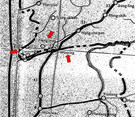
A March 1945 Asia Transportation Map locates Loiwing, and also Mengmao, an older name for present day Ruili, which is across from Burma's Mu-Se (aka Muse) though it does not appear on this map, plus Wanting (aka Wanding), a border crossing point on the Burma Road via the still standing Bailey Bridge over the Wan Jiang River.[1]
Full map available here.
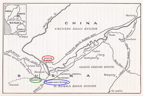
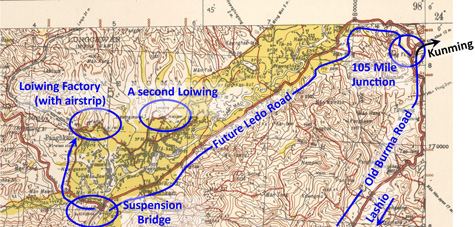
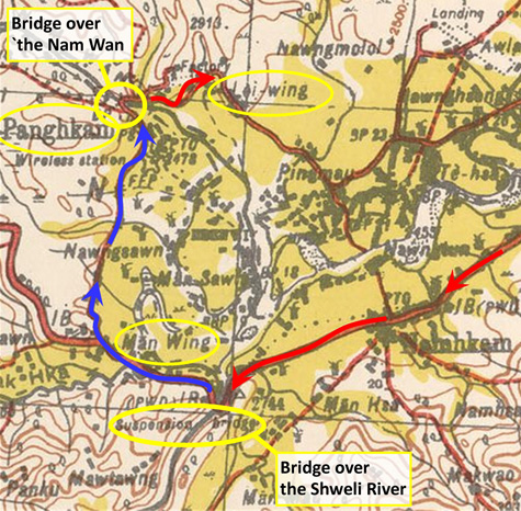
A map from Seagrave's book, Burma Surgeon Returns, shows Loiwing (circled in red), plus two items which figure in later events: the suspension bridge (circled in blue) which Olga Greenlaw's narrative probably describes, and Manwing (circled in green), probably the same Man Wing where some CAMCO employees took up residence after the first bombing of Loiwing in 1940:[2]
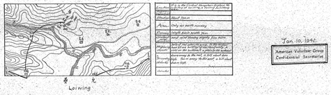
From Nationalist China's 5th Air Base Aerodromes From USAF Archive microfilm with content dated 1941-1942, a rough sketch and description of the Factory airstrip:[3]
High resolution image available here.
Two WWII commentaries describe driving the 250km± from Lashio, Burma to Loiwing, Yunnan, China in March-April 1942. Both seem to have taken the same route. Extracts from the two texts as relevant to Loiwing follow. They both might have used the British Survey of India map of Hsenwi, with this view of the border area between Burma and China (annotated in blue with probable route and significant features):[05]
Scale: gridline spacing ~6.5mi (10.25km)] High resolution image available here.
CDC Dunford Wood kept a diary of his military life from early 1939 through to the Partition of India. Early in that period, assigned to RAF 28 Squadron, he passed through Loiwing. From the diary of CDC Dunford Wood: March 29th 1942 – Loiwing entry [Sunday] China!
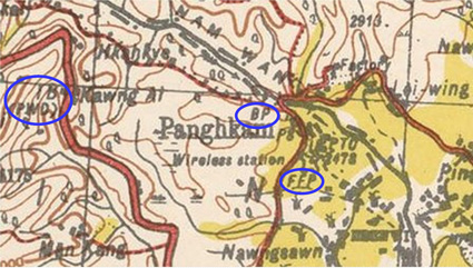
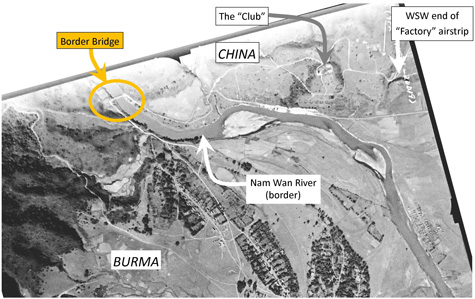
Scale: gridline spacing ~6.5mi (10.25km)] Tentative interpretations of locations mentioned (circled): "IB (PWD)": Inspection Bungalow (Public Works Department), The bridge over which Wood entered China, is no longer in existence; however, it appears in this 1944 aerial photo, with location N23°53.7 E97°36.2:[10]
. . . at Loiwing is CAMCO's works. The sentry has a Kachha looking rifle with a bayonet and two stick bombs in his equipment. . . . I cross the river and walk for some hours in China yesterday . . . . No fuel at Loiwing (the satellite), and they have no permission for aircraft to land there. It's about 10 miles from here over the border.[11]
Scale: gridline spacing ~6.5mi (10.25km)] Tentative interpretations of possible locations (circled): CAMCO's works: "Factory" (circled) at "Loiwing" It's important to note that Wood was sufficiently aware of the "satellite" field to seek it out, on foot no less. His they in "they have no permission for aircraft to land there" would be consistent with his subsequent comments if it referred to the RAF, as distinct from the AVG and USAAF. The British were not looked upon with a kind eye by Chiang Kai-shek: the RAF was limited to use of the Factory airstrip close to the border, and there was some convenience in that since RAF personnel were not allowed to overnight in China. Nonetheless, by 30 April 1942, Woods was using Suili, because, as he would inform in his 04 May 1942 entry, the Factory strip had been out-of-service. Suili's condition must have also gone pretty ragged while he was there, with "hundreds of holes" punched in its runway: April 30th 1942 – Loiwing, China entry [Thursday] . . . there is an alarm and the usual noise heralding the approach of Japanese bombers. . . . They bomb the field and return home. Hundreds of holes in the runaway, a DC3 damaged and repaired next day. The AVG were away from home, ground strafing south of Lashio, where they shoot down some 17 Navy '0's [Zeros]. May 4th 1942 - Calcutta entry [Monday] I set off on the 2nd [02 May] through a hole in the clouds . . . (I got off the satellite because the main field is still O/S [out of service] and we had to burn a perfectly good Blenheim there). Wood was implying that he would normally have used the "main" field, ie, Loiwing Factory. The RAF Blenheim at the Factory strip would have been burned to keep it out of the hands of Japanese troops advancing north from Lashio. So at least one British aircraft had been using Loiwing Factory runway, at least on the day that the field went O/S: which would suggest that the RAF had been assigned to the Factory strip, with the AVG at Suili.
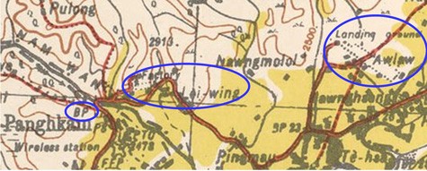
From The Lady and the Tigers by Olga Greenlaw[12] Olga Greenlaw with husband as driver traveled from Lashio to Loiwing, probably in the first week of April 1942 (her presentation is not a diary, so dates are oftentimes uncertain). [From Lashio] . . . drove about 100 miles up the Burma Road, then turned left. (p 134) That left turn would probably have been at the 105 Mile junction (aka Mong Yu, N23°58.5 E97°59.0) where the old Burma Road, which they had followed from Lashio, turned right towards Wanting on its way to Kunming. In turning the opposite direction, they were leaving the old Burma Road onto what would eventually become the Stilwell or Ledo Road coming in from Ledo, Assam, India. After two hours of bumping we came upon a large steel bridge crossing the Shweli river, one of the tributaries of the Irrawaddy. (p 134) Two hours from the left turn could have covered about 50km (as the crow flies), for an average speed of 25kph --- plausible considering her description of the road: "a dirt road so narrow it was difficult to keep the car steady" and "two hours of bumping". That would have gotten her to the only steel bridge crossing the Shweli in that area, a suspension bridge appearing on the small scale Survey of India map of Hsenwi (see Bridge over the Shweli River near bottom margin of this map):[12å]
We were in Chinese territory, Yunnan province! (p 134) This poses a problem: the suspension bridge crossing the Shweli River is firmly in Burmese territory on both sides of the river --- no doubt it was a British-built structure to ease transport within its colonial domain. But it was most certainly the most prominent steel bridge in the area. And perhaps Olga was told that it was the border, and perhaps it was guarded at both ends by uniforms, possibly of indeterminate nationality, or perhaps she took prosaic license to condense details, never imagining that we would be tracing her route today via satellite imagery.[12å1] In any case, it would be easier simply to ignore Olga's last comment and continue with her narrative, picking up with her having crossed the bridge: We made a wide turn, climbed a hill, rattled through two small villages, climbed a higher hill and there was Loiwing. (p 134) Her "wide turn" is consistent with the road layout west of the bridge, turning from traveling northwest across the bridge, to northeast to climb out of the Shweli valley. And she would have "climbed a hill", gaining about 30m in the first kilometer of getting out of the valley. She would have then "rattled through two small villages", Man Wing (N23°49.77 E97°35.67) and Panghkam (today N23°52.55 E97°37.12). She neglects mentioning her crossing the border bridge over the Nam Wan, at N23°53.7 E97°36.2 (the same one that Dunford Wood crossed, as pictured above); but that would have been inconsistent with her premature declaration of being "in Chinese territory". Continuing, in lieu of "climbing a higher hill", she would have passed by a higher hill, about 30m --- that on which the Loiwing Factory clubhouse was situated.
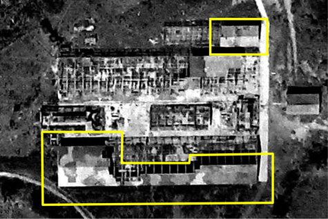
The buildings were whitewashed, with camouflaged corrugated iron roofs. An attractive place and a perfect target for the Japs. (p 134) Indeed, that camo roof was like a beacon, as verified by remaining fragments of roof left on the south side of the factory as seen in this aerial photo almost three years later:[12æ]
And, with the aircraft maintenance / repair function tied to the Factory strip, it would have been a worthy target, or more: possibly the Japanese mistakenly believed that the site was still producing aircraft.
It's important to note that, when Olga asked the question, the Loiwing Factory airstrip was in plain view to both her and her husband. So her question related, as she stated, not to the Factory strip, but to the Airdrome --- Allied intel later referred to it as an Aerodrome, which was Suili, specified as roughly eight miles (~13km) east by road (and five miles (~8km) by air). Several days later, and waiting for space on an aircraft at Suili to Lashio, she noted: Three transports were warming up on the runway. (p 139)[12a1] In addition to Olga's observation, Shores noted that several Blenheims, perhaps as many as ten (6+4) on 19 Apr 1942, might have been present at the air facility at one time.[12b] The numbers tend to confirm that USAAF transport and at least some of (British) bombing operations out of Loiwing had to have been conducted using Suili, not the Factory strip. The latter simply didn't have enough room for all those aircraft. And yet a few days more, back at Loiwing, she recorded: . . . the radio shack, about one mile from the runways. (p 149) Two items to note here: she used the plural, runways, and the Factory strip had only one runway, while Suili had two (and the radio shack couldn't have been equidistant, at one mile, from both the Factory and Suili). In addition, a one mile distance (1610m) would be hard to find between any two features in the compact area of the 860m (940 yd) Factory runway. So the radio shack would have been at Suili. And that implies that Suili was also the air facility in use by Chennault's Flying Tigers. And, to clarify: recalling Dudley Wood's observations (above), at the point in time that he took a walking tour in Yunnan, 29 March 1942, the Factory airstrip was apparently assigned to RAF operations.
|
Coordinates of location names in Wikipedia section: Hangzhou (Hangchow): a.^ Daniel Ford, Flying Tigers (Washington: Smithsonian, 2007), p 29. 0.^ First four paragraphs are a summary of Wikipedia article: Central Aircraft Manufacturing Company, except as otherwise noted. 00.^ ick53993 appears to have first visualized the location of Suili (06 Oct 2007 0534hr post on Yuku Warbirds' Loiwing thread) and the links to the maps vadenstick drew to fine tune ick53993's comments are no longer valid; hence the messages have been removed. Greenlaw, Olga, The Lady and the Tigers (Warbird Books, 2012) Seagrave, Gordon, The Burma Surgeon (New York: Norton, 1943) (hereafter BS) and The Burma Surgeon Returns (New York: Norton, 1946) (hereafter BSR). 1.^ Linked photo of Bailey Bridge (N24°4.832 E98°4.324) at Wanding border crossing is on Tiny Adventures Tours website: Cycling the original Burma Road section 3. Map extract from Kunming N1800-E9800 / 1400x1000, Theater Edition, Revised Mar 1945, Asia Transportation Map 1:2000000, (USAF Archive microfilm roll 25866, pp 098‑109).
2.^ Man Wing location per PA Mathews letter of 26 Oct 1940 quoted in ick53993 lead post initiating Loiwing thread in warbirdsforum.yuku.com. Map titled "Namkham", Seagrave, Gordon S, Burma Surgeon Returns (New York: Norton, 1946), p 244. Annotations by author using Microsoft Publisher. The map also shows an "Alternate Route Burma Road" heading northeast from Loiwing to Wanting. For comment about it, see
3.^ Aerodromes of 5th Air Base HQ: Loiwing (USAF Archive microfilm roll 25866, p 653). Perhaps to state the obvious, map labeling in Chinese characters plus reliance on the metric system for measuring distances indicates the source for the map was Nationalist China.
04.^ Excerpt, ibid
04a.^ Obstacles listed do not match actual terrain.
05.^ Extract from Hsenwi (93 E) No. F-47 B, Provisional GSGS [Geographic Service of the General Staff] 4218 (Survey of India), as the 3rd Ed 1944-AMS 2 (topo data 1926). This edition is dated 1944; however it is assumed that earlier editions by the Great Britain War Office containing much the same information would have been available in 1942. Annotations by author using Microsoft Publisher.
6. (deleted) 7. (deleted)
08.^ Hsenwi, ibid, excerpt, annotated by author using Microsoft Publisher.
9. (deleted)
10.^ Part of image dated 29 Jan 1944, provided by Matt Poole from NARA records (image MP9353 per email of 1004 hrs 09 Dec 2014). Image extracted, tilted so north is up-page, and enhanced with IrfanView; and annotated, with Poole's advice, using Microsoft Publisher; all by author. Coordinates as fitted to Google Earth. For additional information on the bridge, see Locating the border bridge and photo in Nov 1944. with discussion.
11.^ Hsenwi, ibid.
12.^ Greenlaw, Olga, and Daniel Ford, The Lady and the Tigers (?: CreateSpace, 2011). Page references are from the Kindle edition: for which a note of caution --- page numbers seem to vary ±1 over time.
12å.^ Hsenwi, ibid. For more discussion about this bridge, see [page5]
12å1.^ Olga's error in locating the border might also have been caused by her access to a 3rd edition (or earlier) of Motor Roads of Burma, issued by the Burma Oil Co. The 1962 (5th) edition was wrong in 1962 about the Burma-China border, even as it would have been in 1942 (emphasis added): The Shweli River is crossed by a Bailey suspension bridge. The Northern Shan States and Burma border is crossed at Mawswikha [the area where the Shweli River bridge is located], 136 miles from Lashio. The . . . road continues from Mawswikha to Manwing, 2 miles away, where a branch road leads to Panghkam, 4 miles to the north. Manwing is almost on the Shweli River. The river marks the Burma and China border. The 1962 edition states: "The Northern Shan States and Burma border is crossed at Mawswikha": but the northern Shan State with a border on Burma had ceased to exist per the Panglang Agreement in Feb 1947, fifteen years before. Thereafter, the Shweli River at that particular point became the border between the Shan and Kachin States, within Burma. "Manwing is almost on the Shweli River": true, as stated, about two miles distant. However that part of the Shweli two miles distant did not "[mark] the Burma and China border". It was the Shan-Kachin State border. The Nam Wan, about three miles to the northeast, was the international border. Point being: the Burma Oil Co road guide in 1962 was not accurate. It could be assumed that the edition Olga Greenlaw might have had access to in 1942 had been equally inaccurate. 12æ.^ The conspicuousness of the camouflage was pointed out by Matt Poole. Image source: portion of USAFHRA F1309, exposure 9459 of 13 Nov 1944 provided by Matt Poole (email of 0653 hrs 12 Dec 2014). Extracted and enhanced using IrfanView and annotated using Microsoft Publisher, by author.
12a.^ The hill location is N23°53.78 E97°36.87, peak at elevation 795m, about 30m above the Factory airstrip, and 460m past its west end at a 30° angle.
12a1.^ The transports might well have been those described in John Martin, et al (ed), China Airlift --- the Hump: China's Aerial Lifeline, the Beginning, Vol 3 (Nashville: Turner, 1979), p 105. 12b.^ Shores, Christopher et al, Bloody Shambles, Vol I, The Drift to War to the Fall of Singapore (London: Grub Street, 2002), p 368.
13.^ A marked up extract from TPC J-10B of the Loiwing area appears on the Summary page.
|