Japan in Northwest Thailand during World War II
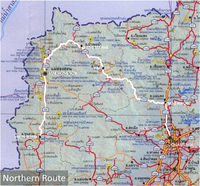
THE NORTHERN ROUTE[1]
(shown in WHITE below)
ww2northernthailand.com is now paralleling this website,
and will replace this website when it expires later this year
| TABLE OF CONTENTS (The roads & stationing shown below are in order from Khun Yuam to Chiang Mai) |
|||||
| Northern Route: Khun Yuam - Mae Hong Son - Pai - Mae Malai - Chiang Mai | |||||
| Accum Km |
Route |
Station |
Description |
||
| ----- | ---- | General | |||
| 0108b | 198 | Khun Yuam | |||
| 0108b | 198 | Museum | |||
| 0108b | 198 | Wat Muai To | |||
| 0108b | 202 | Nong Ka Po | |||
| 0108b | 204 | IJA Road | |||
| 0108b | 212 | Mae Surin | |||
| 0108b | 230 | Huai Pong | |||
| 0108b | 258 | Pha Bong | |||
| 0108b | 265 | Mae Hong Son | |||
| 1095 | 215 | Mae Hong Son | |||
| 1095 | 213+ | Mae Hong Son Airport | |||
| 1095 | 213 | Wat Chong Kham | |||
| 1095 | 200 | Wat Phra | |||
| 1095 | 192 | McGarry crash site | |||
| 1095 | 188 | Huai Pha | |||
| 1095 | 168 | Mae Suya | |||
| 1095 | 168-157 | Forest Protection Unit 15 | |||
| 1095 | 157 | IJA Road | |||
| 1095 | 138 | Pang Mapha | |||
| 1095 | 134 | Pha Mon | |||
| 1095 | 133 | Mon Mai Camp | |||
| 1095 | 130 | Nam Rin | |||
| 1095 | 110 | Soppong | |||
| 1095 | 100 | Pai Airport | |||
| 1095 | 097 | Pai City | |||
| 1095 | 088 | Pai Bridge | |||
| 1095 | 000 | Mae Malai | |||
| 0107 | 036 | Mae Malai | |||
| 0107 | 015 | Mae Rim | |||
| 0107 | 013 | Wat memorial | |||
| 0107 | 009 | Don Kaeo: medical facilities | |||
| 0121: Chiang Mai Outer Ring Road: paralleling Rte 107 (see Route 0107:009 above) |
|||||
| General | |||||
| 004+ | Don Kaeo medical facilities | ||||
NOTES
1.^ Map is extracted from แผนที่ทางหลวงประเทสไทย Scale: 1:1,600,000 (กรุงเทพมหานคร:กรมทางหลวง, 2009) [Road Map of Thailand, Scale 1:1,600,000 (Bangkok: Department of Public Highways, 2009)] (foldout map). Annotations are by author. Routes used by retreating IJA forces are here assumed to approximate currently existing roads.
| First published on Internet | ||
1 |
2012 Jun 10 |
Enlarged table of contents listings |