Japan in Northwest Thailand during World War II
| N18°51.34 E98°57.60 | Don Kaeo (burial site)[1] (Th: ดอนแก้ว / Jp: ドンケオ略図 ) page 1 of 3 |
Route 0107 |
| Text | Notes | |||||||||
|
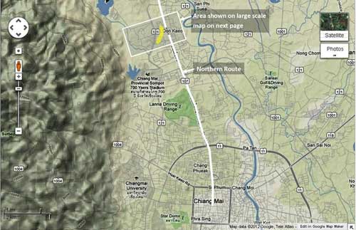
As the Imperial Japanese Army (I J A) withdrew from disastrous defeats in India and Burma, two I J A hospital units were assigned to Don Kaeo,[1a] just north of Chiang Mai, to receive troops wounded from those battles. Already incapacitated and further exhausted from an arduous 280 km trek across the mountains from Mae Hong Son Province, many of those who survived the journey died in the hospital units which were severely underequipped and poorly supplied. The hospitals buried their dead about a half kilometer west of their camps, Neither the locations of the hospital camps nor the associated gravesites are marked on the ground, which is somewhat surprising in view of the nearly 400 remains recovered there and the remains estimated yet to be disinterred. The only reference found for this site to date is in the Japanese language work, Journal on Collection of War Dead: Burma, India, Thailand[1b] That source, however, does itself quote numerous Japanese language references. Key excerpts are presented first, followed by an attempt to match points on the ground with the Journal's map of the site. Photographs of the sites follow. Finally an appendix gives more details from the book. Mentions in the literature: In 1977-1978, Japanese war veteran groups working under the motto . . . "Leave not one body behind". . . . located what they later described as "the largest [single] graveyard" found during their 1977-1978 operations. The remains of 385 IJA troops were recovered there.[2] Commentary includes:
Various comments by investigation team members are cited:
|
See Key for interpreting page content. Revision list. See bottom of Text column on this page. Bibliography supports notes. 1.^ ดอนแก้ว, ie, Don Kaeo, is the Royal Thai Survey Department (RTSD) place name. The name appears in at least two locations on 4746 I. One is a wat which is remote from the burial area; and another, the village, which is in the general area of the burial site.
1a.^ Map is composite of images available in Nations Online Project: Searchable Map and Satellite View of Thailand using Google Earth Data. Annotations are by author. Routes used by retreating IJA forces are here assumed to approximate currently existing roads.
1b.^ 戦没者遺骨収集の記録 ピルマ・インド・タイ [Journal on Collection of War Dead: Burma, India, Thailand] (Tokyo: All Burma Comrades Organization, 1980)[My reference: 03300 journal collecting ija war dead\xlatn by josh].
2.^ ibid, p 447
3.^ ibid, p 446
4.^ ibid, p 447
5.^ ibid, p 447
6.^ ibid, pp 447-448
7.^ ibid, p 448
8. (deleted) |
|||||||||

