| N19°16 E97°56 |
Mae Hong Son Airstrip |
Route 1095 |
| Text | Notes |
|
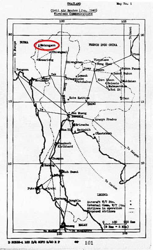
1918-1941 The first data relevant to Mae Hong Son airstrip appeared in 1918, long before its operational start in late 1941. A topographic map was prepared by the Imperial Japanese Army (I J A) and dated 16 September 1941; it was, however, based on Royal Thai Survey Department maps issued in 1918. There were two consequences specific to Mae Hong Son: 1. The name, Muai To, had been used for Mae Hong Son district from 1917 to 1938.[9] Hence, that name is displayed on the IJA map, with "Mae Hong Son" following in parentheses:[9a] Translation: To clarify, while the district name differed during this period, the name of the province, of which it was a part, remained "Mae Hong Son". The duality provides some unnecessary confusion in trying to sort out different accounts of the area. 2. Since it did not exist until 1941, the airstrip does not show on the IJA's 1918 information-based map. The Aerial Transport Company of Thailand, Ltd, had been set up in 1930 to provide civil and commercial air services for Thailand; those services centered on air mail and passenger transport.[9b] The concept had prospered and, by early 1940, a map generated by the US War Department identified Mae Hong Son (Mehongson) as a proposed additional "airline" connection.[10]
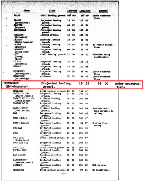
Mae Hong Son is listed under additional airdromes, landing grounds, and seaplane facilities, with status, "under construction":[11]
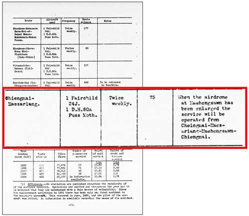
June 1940 By June 1940, the addition of Mae Hong Son to the kingdom's flight network would appear to have been planned for the near future:[12]
In fact, the airstrip there was considered functional by the Allies at the war's start, as it was suspected of being the origin for I J A A F aircraft attacking Toungoo two months later (see entry for 01 February 1942 on page 3).
Three American Volunteer Group (AVG) "Flying Tiger" P-40s based at Toungoo, Burma made a surveillance run on Chiang Mai. The flight may have been visible at Mae Hong Son.[12α]
IJAAF Ki-21s ("Sally"s) based at Hanoi made surveillance runs on Toungoo. Those flights may have been visible at Mae Hong Son.[12ᴂ]
|
9.^ Wikipedia: Mueang Mae Hong Son District 9a.^ Center for Southeast Asian Studies, Kyoto University (CSEAS), メーホン。ソヲーン , No 285: SEAsia-Thailand-File name: Thai6005_003.
9b.^ Young, pp 76-102.
10.^ A Survey of Thailand (Siam) (Washington: US War Department, 15 March 1941), Appendix III (untitled), Map No. 1 dated "Jan 1940", p 101
11.^ ibid, Appendix I - Airdromes, Landing Grounds, and Seaplane facilities of Thailand, v. Additional Airdromes, Landing Grounds and Seaplane Facilities of Thailand, "correct up to April 1940", p 89 (USAF Archive microfilm reel A2874 p1455).
12.^ ibid, Section 45. Civil aviation, f. National air service (3) Operations ("on June 24, 1940"), p 28 (USAF Archive microfilm reel A2874 p1394).
12α.^ Ford, Dan, Flying Tigers (Washington: Smithsonian Books, 2007), p 77.
12ᴂ.^ ibid.
|


