|
Appendices
Major Sources
Summaries of Japanese text translated from
Journal on Collection of Japanese War Dead:
Burma, India, Thailand[58]
08-23 Nov
1977 |
Phase I: Investigation |
17 Jan - 07 Feb
1978 |
Phase II: 1st Collection Effort |
07 - 22 Mar
1978 |
Phase II: 2nd Collection Effort |
[p 422]
. . . In any case, a lesser number entered Thai territory and at Khun Yuam branched off to one of three routes to Chiang Mai:
[1] Northern via Mae Hong Son and Pai [Total 317 km]
[2] Central via Mae Na Chon [Total 197 km (via Ban Kat), or
235 km (thru Doi Inthanon NP), or
274 km (via Mae Chaem & Ob Luang NP]
[3] Southern via Mae Sariang [Total 353 km].
Patients / walking wounded were sent via the northern route because it had fewer steep slopes and a greater number of waypoint stations than the very mountainous (but shorter) central route. In any case, patients generally went north, and [reasonably] graves are by far greater in number along the northern supply route. For those in fairly good physical condition, the central route was a reasonable alternative, but the majority of personnel apparently followed the northern route. It should be noted that some elected not to go over the mountains to Khun Yuam, but rather angled down to Mae Sariang to pick up the less well-marked southern route through Hot.
[p 425]
. . . While the first collection group was collecting remains, a large amount of new information emerged and was returned to the project. This was partly a result of local residents' cooperation upon learning the truth about the collection effort. The first collection group was successful in communicating its main objective; but the effort to improve communication was subordinated as effort poured into the collection process. The 2nd Group worked with patriotic zeal so that no stone would remain unturned, searching out new information as well as reviewing places that reported completed by the first collection group.
Mae Hong Son |
265 |
Ban Kat |
8 |
Khun Yuam |
161 |
Nakhon Pathom |
30 |
Don Kaeo |
117 |
Total |
581 |
[p 450] ] Central Military Supply Line
Compared to the Northern Line, the Khun Yuam - Mae Na Chon - [Ban Kat] - San Pa Tong Central Military Supply Line is only about 60% of the distance, so those who were in a hurry or those who had confidence in their leg strength had chosen this route. The mountains were persistently steep, and it was quite certainly a journey of hardship. . . .
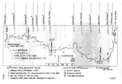
[p 451]
. . . We specifically investigated the Central Military Supply Line in reverse from San Pa Tong towards Mae Na Chon. From information obtained at Ban Kat, we knew the road situation of this same supply line was the following:
1) Fallen trees obstructing the way since the rainy season had not yet been removed.
2) Even after dry weather improved the condition of the road, it still took two days to go to Mae Na Chon, and another two days to reach Khun Yuam (this estimate from an acclimatized, lightly clad local.
3) The mountainous region beyond our current location was said to be uninhabited. [p 452]
4) According to one inhabitant, around the end of the war, no Japanese bodies were seen in this mountain area (this is according to one inhabitant. The observation seems improbable with the number of graves found at Mae Na Chon and Ban Kat indicating the poor condition of some of the soldiers).
When we spoke with the provincial office, we were warned to avoid camping [no reason given]. We abandoned the idea of trying to force our way through [to Khun Yuam], and chose to go only as far as the extremely rugged Mebuin [メブイン: not found [59]]. Mebuin, which is not on the map, was a village with not even 10 households during the war. Afterwards, the government gathered a few tribes and settled the place, so that at the present it is a large village numbering more than 500 in 120 households. From Mebuin about five hundred meters, at the rear of neighboring village Riin [リイン: Huai Rin?[61]], we were able to confirm the burial of one, perhaps two bodies. In the evening, we returned to Ban Kat.
It was said that Japanese people occasionally stopped in Ban Kat. Among those were Japanese whose purpose was unknown, but an old man said that there were many who came to reminisce about the war. This man was particularly concerned about helping the investigation group, and even though he was 80 years old, he showed us around by himself. He gave us his house and welcomed us warmly. Completely contrary to his behavior, most villagers were suspicious of the activities of the Japanese, and this morning, there were people who asked us, "You came to find the treasure, right?" . . . .
[p 452]
. . . The village chief of Mae Na Chon during the war, and who we interviewed in Ban Kat, gave us specific and very useful information about the situation there at that time:
1) Japanese soldiers who had come were relatively healthy, and they had rested at this village for a few days before heading off on the eastern mountain road toward Chiang Mai. . . .
6) Near the end of the war, on average once a week, a group of soldiers would pass by on its way to Chiang Mai.
. . . We reviewed the information we had about Ban Kat, what lay beyond to the west, and our schedule, and we abandoned the objective of investigating the mountain crossing. Those individuals [p 453] who took the Central Supply Line are thought to have been of the "Dragon" or attached forces, and it is assumed that they were in good physical condition because of their participation in many group maneuvers. It is thought that those who needed medical support after leaving Khun Yuam were well enough to get to Mae Na Chon, where medical services were available; similarly, those who fell ill after Mae Na Chon were able to get to medical facilities at Ban Kat. [If 100 bodies lie buried on a hill above Mae Na Chon, and a greater number at Ban Kat, the assumption that none died en route is unrealistic; but as noted later, there was much country through which the road went that was utterly unoccupied, and thus no witnesses.]
The collection group took Ban Kat as its main focus, and tried to do what was possible at the burial site in Mae Na Chon. Along the route connecting the two, with no inhabitants and hence no information, collection was impossible. At Ban Kat in a bamboo grove of about 1300 sq meters,[62] reported to have been a field hospital site, remains were collected. Of course, remains were not complete for smaller skeletal parts had disintegrated.
Ban Kat held the 1/55 and 2/8,[63] but unfortunately behind places like Meevin [メーヴィン: but again assumed to be Mae Win or Sop Win or Huai Rin], collection could not be done. During the second day of the Ban Kat collection, a party led by former Minister of Health and Welfare Watanabe visited us at the site to give encouragement, and the former Minister himself dug with a shovel and uncovered seven bodies.
[p 459]
. . . Group Leader Inoue recorded: The report of the investigation division estimated 129 bodies [east of us]. Most of these, 90%, were in Ban Kat and Mae Na Chon on the Central Military Supply Line.
[p 470]
|
Thailand War Dead Remains Collection Results Chart
|
Location
(city) |
Area |
First Time +
|
Total |
|
. . . Chiang Mai Province[64] |
|
|
| Mae Rim |
Don Kaeo Area |
268+117 = |
385 |
| San Pa Tong |
Ban Kat Area |
55+ 8 = |
63 |
| Mae Taeng |
Papae, Ban Sop Poeng Area |
15 |
15 |
| Chom Thong |
Chon Thong Area |
13 |
13 |
| Hot |
Hot Area |
12 |
12 |
| |
Subtotal |
363+125 = |
488 |
From Report on Archaeological Research for Japanese Soldiers
Burial Project World War II Era - Mae Hong Son Province[64a]
In this Thai language reference, Ban Kat is mentioned only as an intermediate point on the Central Supply Route.
Return to Central Routes page
|
58.^ 戦没者遺骨収集の記録 ピルマ・インド・タイ [Journal on Collection of Japanese War Dead: Burma, India, Thailand] (Tokyo: All Burma Comrades Organization, 1980)
59.^ Mebuin, perhaps as Mae Bu Win, it might have been in an area variously identified on different maps as:
Ban Mae Win [N18°39.38 E98°40.90 (Google Earth, accessed 10 Apr 2012) and generally consistent with The Mae Hong Son Loop (Chiang Mai: Golden Triangle Rider LP, 2002); not shown on RTSD 4746 III "Ban Mai Wang Pha Pun" quad]
or
Ban Sop Win: N18°39.27 E98°41.34 (RTSD 4746 III "Ban Mai Wang Pha Pun" quad); unnamed settlement shows at that location on Google Earth (accessed 10 Apr 2012).
Because of their proximity, Ban Mae Win and Ban Mae Sop are probably effectively the same.
60. (deleted)
61.^ Ban Huai Rin: N18°40.6 E98°38.1 --- approximate only, shows only on Map of Mae Hong Son Scale 1:180,000 (Bangkok: Prannok Witthaya Maps Center, [undated]); ISBN 974-7675-57-9
62.^ ~400 tsubo (2400 square shaku or 1322.4 square meters)
63.^ ie, the 55 remains recovered by the 1st search group, and the 8 by the 2nd search group.
64.^ Changwat Chiang Mai (Bangkok: Royal Thai Survey Department, 1996)
64a.^ รายงาน การ สําร จอขุดค้น ตาม โครงการ คึกษาเชิงอนรักษ์แหล่งฝังศพทหารญี่บุน สมัย สงครามโลกครั้งที่ 2 จังหวัดแม่ฮ่องสอน หัางหุ้นส่วนจํากัดเฌอกรีน
[Report on Archaeological Research for the Japanese Soldiers Burial Project World War II Era - Mae Hong Son Province (Chiang Mai: Green Tree, LLP, Ltd, submitted by / for Mae Hong Son Province Archaeology National Museum Office 6, Chiang Mai, 1999)] |