|
1943
10-19 January 1943: From Lampang, RTAF Squadrons 11 and 12, each flying 11 Ki-30 light bombers attacked Chinese Nationalist forces in Mongyong, Mongyang, Mongmanay, and Mong Chiangrung, Burma.[13҂]
RTAF Squadron 16 with nine Ki-21 heavy bombers apparently did a follow-up attack on the last listed, Mong Chiangrung, later in this period. This was probably the event that Young recorded as 24 or 28 January (next item).[13҂1]
24 January 1943: RTAF Squadrons 11 and 12 bombed Chinese forces at Chieng Lung in support of advancing Royal Thai Army contingents.
[13҂2]
28 January 1943: RTAF Squadrons 11 and 12 again bombed Chinese forces at Chieng Lung.[13҂3]
29 January 1943: RTAF Squadrons 11, 12, and 62 attacked a Chinese base near Mong Sae.[13҂4]
26 February 1943: Hostilities between Thai and Chinese forces ended informally and RTAF Squadrons 11, 12, and 62 bombing missions ended. Subsequently Squadrons 11, 12, and 16 performed only reconnaissance missions over the Shan States.[13҂5]
19 May 1943: This is the earliest detailed rendering of Lampang Airport currently available:[13]
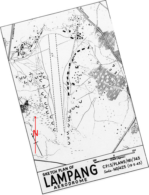
The north arrow on the sketch is in error and true north is shown as the superimposed red arrow. The image has been reoriented with true north to the top-of-page.[13a] Note that no key or legend was provided for this sketch.
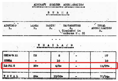
October 1943: Airfield Report No. 15 provided counts of "aircraft shelter accommodation" at the Lampang Airport. On the sketch above, dated 19 May 1943, 28 shelters were depicted. This number, smaller than the counts below, was not inconsistent, since neither the number demolished nor that added after the sketch was made are defined.
 [14] [14]
TRANSCRIPT:
|
AIRCRAFT SHELTER ACCOMMODATION
|
|
Item
|
Description
|
| 1. AIRFIELD
|
LAMPANG |
| 2. LARGE |
32+ |
| 3. MEDIUM |
4/5+ |
| 4. HANGARETTES |
(included in
figures above) |
5. TOTAL
ACCOMMODATION |
36/37+ |
[15]
TRANSCRIPT:
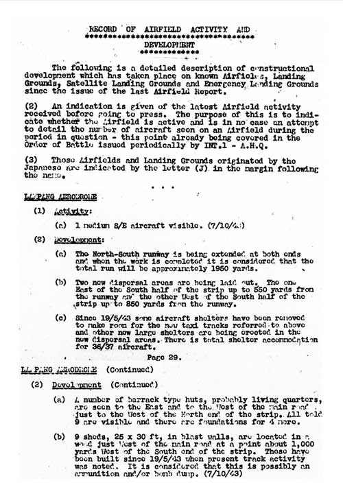
LAMPANG AERODROME
(1) Activity:
(a) 1 medium S/E [single engined] aircraft visible (7/10/43)
(2) Development:
(a) The NS runway is being extended at both ends and
when the work is completed it is considered that the
total run will be approximately 1950 yards [In map
sketch above, dated 19 May 1943, length was about
1200 yards; to contrast, in the aerial photo below
dated 22 Oct 1943, just six months later, the length
was about 1800 yards].
(b) Two new dispersal areas are being laid out. The one
east of the south
half of the strip up to 550 yards from
this runway
and the other west of the south half of
the strip up to
850 yards from the runway.
[In the next aerial photo, the "dispersal" zones are
labeled, but barely visible; hence the two labels are
circled in red]
(c) Since 19/5/43 some aircraft shelters have been removed
to make room for the new taxi tracks referred to above
and other new large shelters are being erected in the
new dispersal areas. There is total shelter
accommodation for 36/37 aircraft.
[d] A number of barrack type huts, probably living quarters,
are seen to the east and to the west of the main road,
just to the west of the north end of the strip. All told 9
are visible and there are foundations for 4 more [This
area seems to have been either excluded from the
sketch since little of the "main road" to the left, or west,
is visible; the markups were omitted from the sketch.
The structures may have been referenced as
"demolished" a year later in the 11 Nov 1944 sketch].
[e] 9 sheds, 25 x 30 feet, in blast walls, are located in a
wood just west of the main road at a point about
1,000 yards west of the south end of the strip. Those
have been built since 19/5/43 when present track activity
was noted. It is considered that this is possibly an
ammunition and/or bomb dump. (7/10/43) [Again, as with
[d], this area seems to have been well off the sketch to
the left, or west; the area is probably the "Dump" as
labeled in the 11 Nov 1944 sketch].
Use of the "19 May 1943" date in items (c) and [e] implies that the map sketch above, of that same date, or the backup for that map, was being referenced in the text.
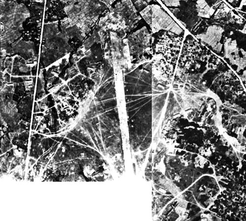
22 October 1943: This is the earliest WW2 aerial photo
of the air facility at Lampang currently available. In comparison with the map sketch above, large scale development on both sides of the N-S runway is obvious:
[16]
-AF-aerial-Oct-43a.jpg)
North on the sketch above is in error and the image has been reoriented with true north to the top-of-page. The black lines outlining the runway and two black diagonal lines intersecting the runway are on the original image; aside from those outlining the runway, their purpose is not clear. In the two areas "circled" are labels "NEW DISPERSAL", which are difficult to see in the poor quality reproduction.
November 1943: Around 01 August 1943, in preparing to invade India, IJA forces had been ordered to build / improve a land connection between the railhead at Chiang Mai and Toungoo, Burma. On 09 November 1943, it became obvious that the connection could not be completed in time. As a result, the IJA chose to rely instead on the existing land connection north from Lampang to Kengtung (and then points west).[16a] Probably before that 09 November 1943 date, the IJA mounted a concerted effort to improve the Lampang railyard and the road north to support its planned invasion of India.[16b]
The November miniature summarized:
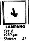 [17] [17]
Category (Cat) B = All weather runway (probably asphalted surface, with adequate provision for storm water drainage.)
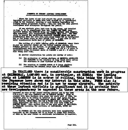
Though apparently not aware of the IJA plan to invade India, much less the redirection of the support route through Lampang, Airport Report No. 16 did pay much attention to Lampang. "Considerable" construction work was here noted in progress in Lampang:
[18]
Fairly detailed information was provided about the facility:
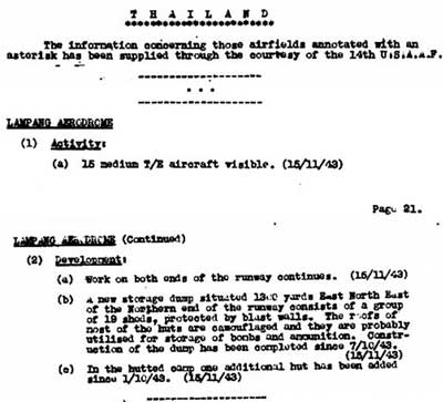 [19] [19]
TRANSCRIPT:
LAMPANG AERODROME
(1) Activity:
(a) 15 medium T/E [twin engined] aircraft visible (15/11/43)
[Such an observation would be approximately consistent
with the assignment of RTAF Squadron 62 with nine
Ki-21s to Lampang plus RTAF Squadron 61 plus five
Martin Model 139s visiting from Phrae.[19a]]
(2) Development:
(a) Work on both ends of the runway continues. (15/11/43)
(b) A new storage dump situated 1200 yards ENE of the
northern end of the runway consists of a group of 19
sheds, protected by blast walls. The roofs of most of the
huts are camouflaged and they are probably utilized for
storage of bombs and ammunition. Construction of the
dump has been completed since 7/10/43 (15/11/43)
(c) In the hutted camp one additional hut has been added
since 1/10/43. (15/11/43)
It is not clear to what previous publication the following amendments were to apply (certain earlier Airfield Reports are not yet available); however, Airfield Report No 15 (October 1943) did not carry a summary in a format to which this might apply. The content suggests a format similar to that shown in the 30 April 1944, which is the first example currently available:
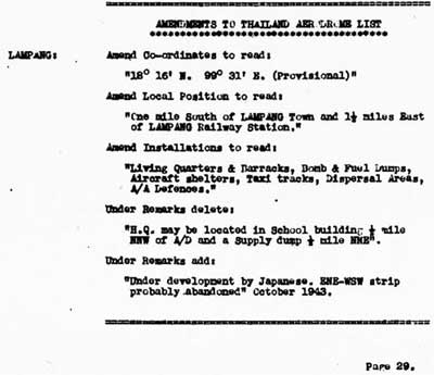 [20] [20]
TRANSCRIPT:
LAMPANG:
Amend Co-ordinates to read:
"18° 16' N 99° 31' E (provisional)"
Amend Local Position to read:
"One mile south of Lampang town and 1-1/2 miles east of
Lampang Railway Station."
Amend Installations to read:
"Living quarters & barracks, bomb & fuel dumps, aircraft
shelters, taxi tracks, dispersal areas, AA defenses."
Under Remarks delete:
"HQ may be located in school building 1/2 miles NNW of A/D
[aerodrome] and a supply dump 1/2 mile NNE."
Under Remarks add:
"Under development by Japanese. ENE-WSW strip probably
abandoned" October 1943.
15 November 1943: Allied photo-reconnaissance aircraft made two passes over the general Lampang area so that a mosaic of fourteen photos could be assembled of the area:
[20a]
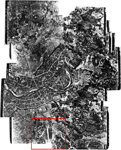
The general airport area, specifically of interest here, is outlined in red. The photomosaic is discussed in more detail at Lampang Williams-Hunt Aerial Photomosaic.
Enlarged, the area outlined in red looks like this:
[20b]
Unfortunately, in this photomosaic, which is the only one currently available of Lampang during WW2, the airfield was only partly visible on the edge of the sequence of photos. The airfield was apparently not of primary interest for this particular effort.
20 November 1943: The USAAF 14th Air Force 308th Bomb Group, flying B‑24s out of the Kunming area in Yunnan Province, made its first raid on Lampang Airfield.[20c]
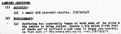
18 December 1943: Improvements at Lampang continued:
 [21] [21]
TRANSCRIPT:
LAMPANG AERODROME
(1) Activity:
(a) 1 small S/E [single engined] aircraft visible. (18/12/43)
(2) Development:
(a) Surfacing has apparently begun at both ends of the strip &
the centre is being rolled. Approx 1-3/4 miles NE of south
end of airfield a new camp is being constructed, on E side
of Chiang Mai-Chiang Rai Road. (18/12/43)
25 December 1943: Compare the following photo, as rough as it is, with the one dated about two months earlier, above, and note the further development in the area around the south half of the airfield:
[21å]
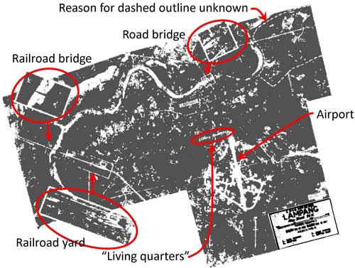
North on the sketch is in error and the image has been reoriented with true north pointing to top-of-page.
Titles for the insets, circled in red, are transcribed in large font. The "Road Bridge" is the Ratchadaphisak which ironically was later wrongly identified in a June 1945 Allied Tabulation of Target Information as the "Railroad Bridge". It was probably called out here because its white color made it easy to pick out from the air.
31 December 1943
From the USAAF Chronology:
CBI - THEATER OF OPERATIONS - CHINA (14AF): In China, 25 B-24s pound the Lampang railroad yards, causing several big fires and many secondary explosions.[21a]
Six Thai fighters were mustered to meet the B-24s, probably from Squadron 16, based at Lampang and flying either Curtiss-Hawk 75s or Ki-27s. With this, their first experience with B‑24s, even though the B‑24s were not escorted, the Thai pilots kept their distance.[21b]
Aerial reconnaissance continued to record improvements at Lampang:
 [22] [22]
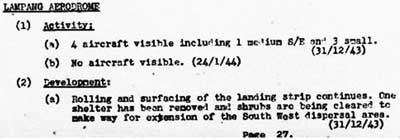
TRANSCRIPT:
LAMPANG AERODROME
(1) Activity:
(a) 4 aircraft visible including 1 medium S/E [single engined]
and 3 small. (31/12/43)
(b) No aircraft visible. (24/1/44)
(2) Development:
(a) Rolling and surfacing of the landing strip continues. One
shelter has been removed and shrubs are being cleared
to make way for expansion of the SE dispersal area.
(31/12/43)
An anti-aircraft (AA) emplacement was identified on this date. See Item 2 in summary of AA batteries around Lampang.
Continued on next page
|
13҂.^ RTAF 1913-1983, p 327.
Young identified activities in this period as 11-12 Jan 1943, targeting only Mong Yang and Mong Hai; and 12 Jan 1943, targeting only Chieng Bung, p 194.
These four locations in Burma need coordinates.
13҂1.^ RTAF 1913-1983, p 327.
13҂2.^ Young, p 195.
13҂3.^ ibid.
13҂4.^ ibid.
13҂5.^ ibid.
13.^ Airfield Report No. 15, Oct 1943, p 7 (USAF Archive microfilm reel A8055 p 0136). But note that the map itself is dated 19 May 1943.
The "U"s and "V"s represent "aircraft shelter accommodation". Compare with the table which follows and later maps.
13a.^ Unless specifically noted otherwise, all maps are rotated as necessary so that north points to the top of the page. This conforms to standard practice, and allows easy comparison between different maps.
14.^ Airfield Report No. 15, Oct 1943, p 9
(USAF Archive microfilm reel A8055 p 0162).
An enlarged copy of the page shows accommodation at Lampang as 35/37+.
Plus the column total for "Medium" reads 19/20+.
15.^ Airfield Report No. 15, Oct 1943, pp 29, 30 (USAF Archive microfilm reel A8055 pp 0182, 0183).
Find "Order of Battle issued periodically" para (2).
Details in text need correlation with aerial photos.
16.^ Airfield Report No. 15, Oct 1943, unnumbered page (USAF Archive microfilm reel A8055 p 0196).
While this is a poor quality reproduction, the development adjacent to the south half of the runway is very clear and should be correlated with other better quality aerial photos.
16a.^戦史叢書 : Vol 15: インパール作戦―ビルマの防衛
(東京: 防衛庁防衛研修所戦史室 (編集), 1968年). Senshi Sosho, v 15, Imphal maneuvers - Burmese defense (Tokyo: Asagumo, 1968), p 139.
16b.^ Young, p 201.
17.^ Airfield Report No. 16, Nov 1943, "Airfield Miniatures", unnumbered page (USAF Archive microfilm reel A8055 p 0230).
18.^ Airfield Report No. 16, Nov 1943, p III
(USAF Archive microfilm reel A8055 p 0236).
19.^ Airfield Report No. 16, Nov 1943, pp 21, 22
(USAF Archive microfilm reel A8055 pp 0276, 0277).
The note in the heading, "information concerning those airfields annotated with an asterisk has been supplied through the courtesy of the 14th USAAF" does not apply to Lampang (no asterisk). However, the "14th" included the 21st Photographic Reconnaissance Squadron (21PRS) for which some records are presented here, starting on 09 Jan 1944. The unit was assigned to Kunming, China at that time (Per Wikipedia).
19a.^ Young, ibid, pp 185-189.
IJAAF 70th Independent Chutai had been shown located at Lampang on 20 Mar 1942, with 31 Ki‑21s; if still present, some of its "T/E" aircraft might have been amongst those sighted.
20.^ Airfield Report No. 16, Nov 1943, p 29
(USAF Archive microfilm reel A8055 p 0284).
20a.^ From:
• Williams-Hunt Aerial Photos Collection
• Original from the School of Oriental and African Studies (SOAS), University of London
• Digital Data from Center for Southeast Asia Studies (CSEAS), Kyoto University
• Digital Archive from Chulachomklao Royal Military Academy (CRMA), Thailand
The individual photos used in the mosaic are identified here.
20b.^ 02541.jpg and 02548.jpg, ibid.
20c.^ Young, ibid, p 201. He cites his source as "US Army G-2 Regional Files, Thailand, File 9185, RG165, NA" (p 301 n 104) which are (obviously) not easily accessible. There is no confirming report from more general sources, either USAAF or Thai. The Lampang railyard was well-reported by those sources as having been attacked 31 December 1943 (see below).
The 308th Bomber Group was located at three fields in and around Kunming, Yunnan Province: Yang Kai, Cheng Kung, and Kunming. (308th Bombardment Group)
21.^ Airfield Report No. 17, Dec 1943, p II
(USAF Archive microfilm reel A8055 p 0329).
21å.^ Airfield Report No. 21, Apr 1944, unnumbered page (USAF Archive microfilm reel A8055 p 0658). Note that photo is dated 25 Dec 1943. Photo has been reoriented so that north is towards the top of the page.
21a.^ Carter, KC and R Mueller, compilers, Combat Chronology 1941-1945: US Army Air Forces in World War II (Washington: Center for Air Force History, 1991), unpaginated.
21b.^ Young, ibid, p 201. RTAF 1913-1983 records that Squadron 16 was based at Lampang (p 327). J-aircraft records that the squadron was based there only in "late 1943" (Japanese aircraft in RTAF and RTN service during WWII).
22.^ Airfield Report No. 18, Jan 1944, p 27
(USAF Archive microfilm reel A8055 p 0470).
|