| N18°17 E99°28 |
Lampang Airport (Th: ลำปาง ลำพูน / Jp: ランパーン 滑走路 ) page 4a of 7 |
Route 0001 Station 00c |
| Text | Notes |
|
03 Jan 1944: CBI - THEATER OF OPERATIONS - CHINA (14AF): In China, 28 B-24s attacked the railroad yards at Lampang.[24҂] This was the second major attack on the Lampang rail yards in four days [previous attack here]. This flight was escorted by two USAAF 449th Fighter Squadron P-38 Lightnings. Four Thai fighters sent up did not engage.[24ж]
The flight path, as determined by the target locations, followed the railroad --- aside from Ko Kha, a satellite airstrip about 13 km southwest of the Lampang airport. No aerial photography related to this report has been found as of 30 September 2013.
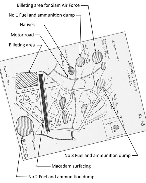
Note that "Shelters" had increased from 32+ reported in October 1943, to 37 reported in November 1943 to 49 here in January 1944. The increase was in keeping with this observation noted in the January 1944 Airfield Report: As with previous corrections noted, it is unfortunately unclear which previous report this was intended to corrected.
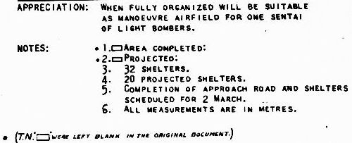
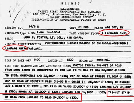
Comment: One sentai of light bombers: "up to 30 aircraft".[27a1] Note 5, "Completion of approach road and shelters scheduled for 2 March" strongly implies that there was an intelligence source on the ground. Note that the sketch here does not conform well with that of the "miniature" near the top of this page, nor the aerial photos dated 22 October 1943 and 25 December 1943. The sketch's crudity, and its lack of similarity to aerial photos and other sketches, suggests again that the information for it was provided by an on-the-ground source. 07 Feb 1944: Aerial photos were taken at Lampang plus about 85 km along the roadway north (Phahonyothin Road (future Thai Route 1)) to Ngao[27a2] (N18°45.6 E99°59.2)[27a3], this the road to the border crossing into Burma at Mae Sai / Tachilek (in all, about 290 km distant from Lampang):[27a4]
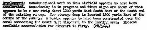
No orientation was given for that "new strip": if it were a new strip and not a taxiway, it might have been intended as a parallel runway, the philosophy of which was described by Allied intel here. Note that resurfacing was clarified in the next month's report with the runway surface defined as "rolled earth"; probably "resurfacing" for the dirt runway consisted of "smoothing"; ie, low spots and rutting were filled in, fill edges were feathered out, and the whole of the runway was then rolled. It is curious that such work was performed just prior to the onset of the rainy season; normally such remedial work was conducted after the ravages of a rainy season. This therefore might have been done in anticipation of providing support for the IJA's imminent attempt to invade India.
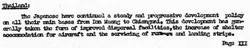
The Airfield Report for April included some substantial analyses. Regarding Lampang were "Comments on Current Development", which offered some perspective on local conditions in Thailand:
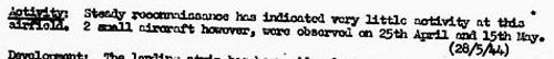
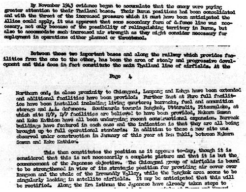
The . . . main [feature] of aircraft intelligence on Thailand over the last month has been . . . the steady preparation of maintenance work on their main base prior to the southwest monsoon season. This has been noted at Don Muang, Chiang Mai, Lampang, Nakorn Sawan, Koko Kathien, Phitsanulok, and Uttaradit. . . . From this, it would appear that Allied intelligence was attributing maintenance work on airfields solely to anticipated weather. However, that view was modified on the next page of the report in an analysis titled "Review of Airfield Development in Thailand": TRANSCRIPT of relevant parts, (emphasis mine): By November 1943 evidence began to accumulate that the enemy were paying greater attention to their Thailand bases. Their Burma positions had been consolidated and with the threat of the increased pressure which it must have been anticipated the Allies could apply, it was apparent that some secondary form of defence line was necessary, not only because of the possibility of relinquishing territory in Burma, but also to accommodate such increased air strength as they might consider necessary for employment in operations either planned or threatened. . . . . . . Between these two important bases [of Chiang Mai and Bangkok] and along the railway which provides facilities from the one to the other, has been the area of steady and progressive development and this does in fact constitute the main Thailand line of airfields. At the northern end, in close proximity to Chiang Mai, Lampang and Ko Kha [runways] have been extended and additional facilities have been provided. . . . This then constitutes the position as it appears today, though it is considered that this is not necessarily a complete picture and that it is but the commencement of the Japanese objective. The Chiang Mai group of airfields is bound to be strengthened in view of its strategic position for providing air cover over Rangoon and the whole of the Irrawaddy Valley . . . . Note that this review was prepared before the IJA's not defensive effort, but rather its offensive began with its attempt to invade India. At the mentioned date, November 1943, Lampang had just been designated a transfer point for troops and supplies moving towards the invasion point in Burma --- north by rail from Bangkok to Lampang; thereafter by foot or vehicle on the road north through the Thai-Burma border towns, Mae Sai and Tachilek; on to Kengtung in Burma; and then west to assembly points for the IJA invasion of India. While evaluating Thai airfield improvements as possibly to "accommodate . . . increased air strength", Allied intelligence, in noting the many aircraft at Bangkok at this time, seemed to fail to consider the consistent lack of aircraft reported on airfields in the northwest of Thailand: for example, despite 32 aircraft shelters at Ko Kha, no aircraft were ever sighted there. Having 50 shelters, Lampang was never recorded with many aircraft sighted, save for 15 November 1943 (and this dearth continued with the next report, of 21 April 1944, though this would apparently have been a testimony to the success of the RTAF, and possibly the IJAAF, in hiding aircraft since RTAF Squadrons 11, 12, 16, and 62 plus possible IJAAF units were located there). The point here is that Allied intel did not seem aware of an absolute decrease in number of IJAAF aircraft because of an inability of Japanese factories to produce sufficient aircraft to replace those lost in battle. An important concept was first presented here, "the main Thailand line of airfields". It would first be graphically presented in October 1944's Airfield Report. 21 April 1944: Surveillance was becoming more consistent and never found more than "two or three aircraft" at Lampang:
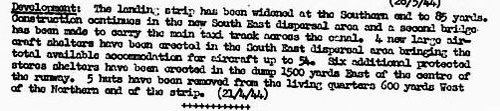
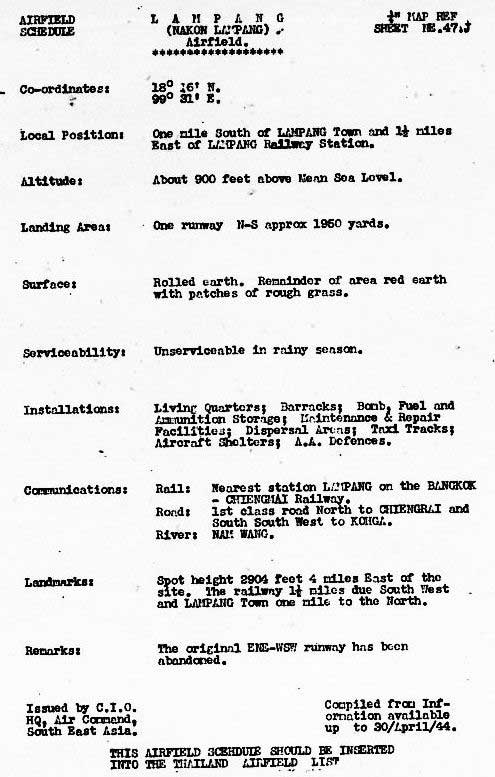
In the April Airfield Report was a more formal and detailed presentation about the facility, evidencing a growing sophistication in Allied intelligence gathering and reporting: A key detail to note: the 28 March 1944 report described "resurfacing" in progress, which this report a month later clarified: the surface was "rolled earth" and "unserviceable in rainy season". Curiously, the Ko Kha airstrip, assumed by Allied intel to be a satellite of Lampang, was "metalled"; ie, surfaced with crushed stone, and truly all-weather.[30c1] "The original ENE-WSW runway", said to have been abandoned in the Remarks: there is no specific information currently available about that original runway and its alignment, though that information can be inferred, as indicated in the March 1940 entry here. The earlier mention of a ENE-WSW runway said that it had been "probably abandoned" [in] October 1943" and attributed it to a Japanese effort, not a Thai effort (and ironically the ENE-WSW runway next appears in January 1945 with remark "revived and extended" with a length of 1400 yards under construction).
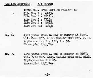
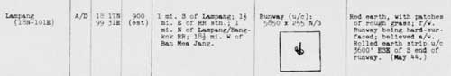
Detailing of airfield improvements continued in Allied reporting: TRANSCRIPT of second report above: Red earth, with patches of rough grass; f/w [fair weather].
While the locations may appear well defined, they suffer from three major sources of error: 1. The south end of the runway is used as a reference point in locating six of the seven emplacements. The south end is itself not clearly defined. 2. Distances appear to be stated to the nearest 50 yard increment, that is, ±25 yards. To give that some perspective, the width between painted margins on the current runway at Lampang measures 13 yards; so, accuracy is plus or minus two runway widths. 3. The bearings are measured from true north; however, with the bearing of the runway assumed constant and with a current true bearing of 355°, per Google Earth, a comparison of north arrows among different views of the airfield finds significant differences between what is used as "true" north.[33ƃ]
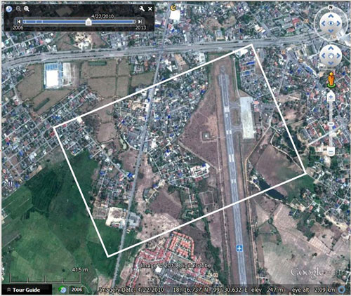
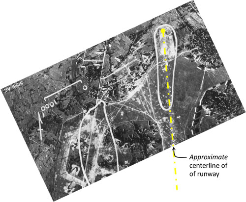
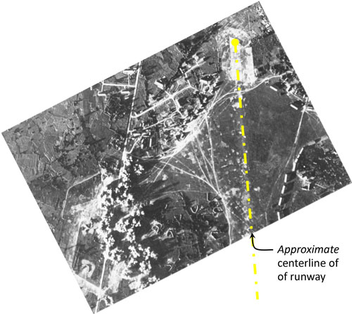
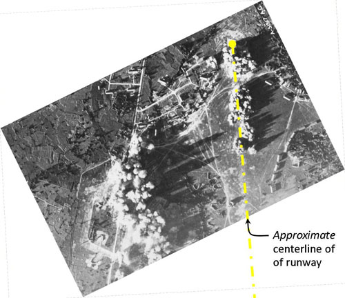
Attack on Lampang: With date unspecified, the following series of three photos titled "War Theatre #11 (Lampang A/F, Thailand) - BOMBING" was released for publication on 23 June 1944.[34] Photos have been reoriented with approximate north towards the top of the page and scales standardized amongst the three. Location of the three is in the area of the north end of the current N-S runway as outlined below in white, which seems to coincide with that of the WW2 runway:
Original caption: Lampang Airfield, Thailand was target for one of the 7th Group's most effective missions. Two squadrons were briefed to bomb parking area [at lower left], third, runways, and fourth, installations at end of runway [upper right].
Original caption: Bombing of Lampang Airfield, Thailand.
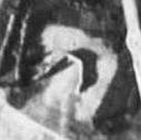
Original caption: Bombing of Lampang Airfield, Thailand after last two squadrons had attacked. Installation and runway had been neatly pinpointed. The long shadows, noticeable particularly in the third photo, indicate the attack occurred quite late in the afternoon. The various features in the three photos above, looking similar to "U" or "V" in different orientations, were aircraft shelters. For further analysis of the detail in the photos, see discussion under January 1945. Here is a substantial enlargement from one of the aerial photos above of a typical aircraft shelter: Curiously, the USAAF Chronology for 1944 does not mention any activity near this time around Lampang.
|
24҂.^ The Official Chronology of the US Army Airforce in World War II: 1944. (hereafter USAAF Chrono 1944)
24ж.^. Young, ibid, p 201.
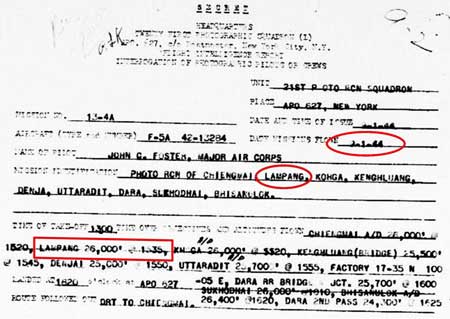
24œ.^ 21st Photographic Reconnaissance Squadron (hereafter 21PRS) Report Mission No. 13-4A, 09 Jan 1944 (USAF Archive microfilm reel A0878 p 0197). The aerial photo reconnaissance reports included here record coverage of Lampang by only the 21st Photographic Reconnaissance Squadron (21PRS) starting in January 1944. Other Allied units provided similar coverage, but their flight records have not yet been released (Nov 2012).
24.^ Airfield Report No. 18, Jan 1944, unnumbered page (USAF Archive microfilm reel A8055 p 422).
25.^ Airfield Report No. 18, Jan 1944, p 36 (USAF Archive microfilm reel A8055 p 475).
26. (deleted)
27.^ Publication No. 3.II: Plans of Airfields in French Indo-China and Siam, (?: Southeast Asia Translation and Interrogation Center 30 Nov 1944), unnumbered page (USAF Archive microfilm reel A8023 p 454). Maps are reoriented as necessary so that north is "up" the page to ease comparison amongst all maps.
27a.^ ibid, extract, rotated.
27a1.^ Wikipedia, Imperial Japanese Army Air Service: Operational Organization.
27a2.^ Aka Luangnuea, LuangNua (Thailand Operations Record, Japanese Monograph No 177 (Washington: Department of the Army, 1953?), p iii; Ban Luang Nua (Weekly Intelligence Summary, No. 30 27a3.^ Coordinates from Google Earth 27a4.^ Distances per A2Z Atlas of Northern Thailand (Bangkok: PN Map Center, 2006), pp 2, 16. 27b.^ 21PRS Report Mission No. 14/6 A, 07 Feb 1944 (USAF archive microfilm reel A0878 p 0155).
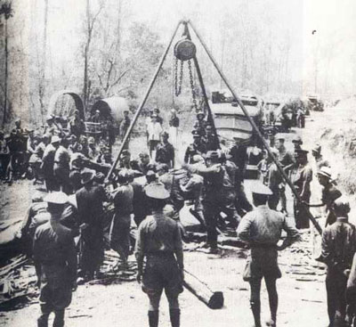
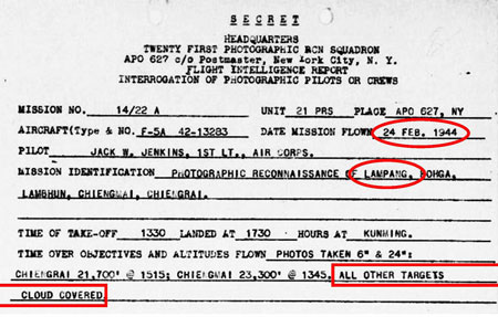
27b1.^ Photo from Axis History Forum. Wisarut Bholsithi in that forum on 21 Jun 2004 suggested the probable locale for the photo: the main road between Lampang and Mae Sai on the border with Burma. He also indicated that the work pictured would likely have occurred during 1942-1943 to facilitate RTA troop movement to the eastern part of Shan State in 1942 and IJA troop movement beginning in Nov 1943 towards western Burma in support of its attempted invasion of India in early 1944. No aerial photo flight reports are currently available prior to Jan 1944; so this report was perhaps a continuation of an effort to monitor activity along the road. On the other hand, no mention of such activity is made in any Allied report (currently available) prior to this time. 27c.^ Airfield Report No. 19, Feb 1944, p 24 The "small" aircraft periodically recorded might have been a mail plane that connected Lampang, RTA facilities in Burma, and Bangkok in the south via Phrae and Phitsanulok, described by Young, ibid, p 216. 27c1.^ 21PRS Report Mission No. 14/22 A, 24 Feb 1944
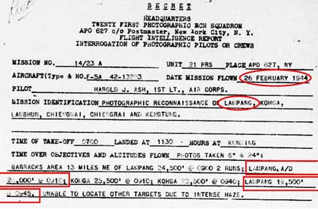
27d.^ 21PRS Report Mission No. 14/23 A, 26 Feb 1944
27e.^Airfield Report No. 22, May 1944, p 14
28. deleted 28a. deleted
28a1.^ Airfield Report No. 21, Apr 1944, p 3
29.^ Airfield Report No. 21, Apr 1944, p 3
30.^ Airfield Report No. 21, Apr 1944, p XVII
30a.^Airfield Report No. 22, May 1944, p 14
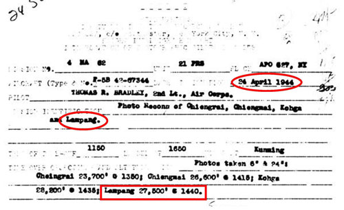
30b.^ 21PRS Report Mission No. 4 MA 62, 24 Apr 1944
30c.^ Airfield Report No. 21, Apr 1944, unnumbered page (USAF archive microfilm reel A8055 p 0669).
30c1.^ Definition of the term, "metalled road" is discussed here in Notes column.
31.^ Airfield Report No. 22, May 1944, p III
32.^ Provisional Airfield List: Southeast Asia, Enemy Airfield Information, Report No. 3 (Washington: Office of Assistant Chief of Air Staff, 2? Jul 1944) p 62
33.^ "Thailand: Alphabetical List of Main Target Areas", Record of Japanese Anti Aircraft Defenses, (?: CIO, HQ, AC, SEA, Jul 1944(?)), unnumbered page
33Ƌ.^ "Amendments to Target Areas", Record of Japanese Anti Aircraft Defenses, (?: CIO, HQ, AC, SEA, Jul 1944(?)), p 5 (USAF Archive microfilm reel A8063 p 168). 33ƃ.^ In the late 1960s, I enjoyed hiking in the mountains overlooking Japan's Inland Sea from Iwakuni to Hiroshima. One of those hikes took me to an overlook above Hiroshima where I found concrete foundations for an anti-aircraft battery. I had hoped that such might be visible here, but the locations provided are nebulous. Also, cement was not common in northern Thailand at that time, as evidenced by the lack of concrete roads and runways. Further, AA field units would probably have been used and these were designed to be secured on raw earth with stakes:
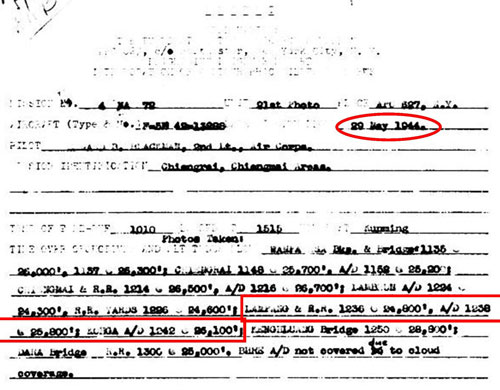
Hence there would be no evidence to be seen on the ground today. (Photo: Handbook Japanese Military Forces (Washington: USGPO, 1944), (reprint: Isby, David and Jeffrey Ethell (Baton Route: Louisiana State University Press, 1991)), p 236) 33å.^ Airfield Report No. 22, May 1944, p 14 (USAF Archive microfilm reel A8055 p 752). 33a.^ 21PRS Report Mission No. 4 MA 72, 29 May 1944 (USAF archive microfilm reel A0878, p 10).
34.^ Pantip website incorrectly uses "23 June 1944" to date the event. The back of the photo reads: Rel for Pub [released for publication] BPR [?] 23 Jun 44 (1) WD. (Note added 14 Apr 2014) 34a.^ Image consists of: Google Earth Imagery data: 22 April 2010
Annotation with rectangular overlay by author using Microsoft Publisher.
34b.^ Photo and caption source: NARA Reference Number: 342-FH-3A04832-51516AC via Fold3: Lampang Airfield, Thailand.
34c.^ Photo and caption source: NARA Reference Number: 342-FH-3A04833-51517AC via Fold3: Bombing of Lampang Airfield, Thailand..
34d.^ Photo and caption source: NARA Reference Number: 342-FH-3A04834-A51517AC via Fold3: Bombing of Lampang.
34e.^ Extract from aerial photo recorded in note 34b above; annotation added with Microsoft Publisher. |

.jpg)
.jpg)
.jpg)
.jpg)