Japan in Northwest Thailand during World War II
| N18°16 E99°30[1] |
Lampang[1a] Airport (Th: ลำปาง ลำพูน / Jp: ランパーン 滑走路 ) Page 1 of 7 |
Routes 0001 and 0011[2] |
| Text | Notes | ||||||||||||||||
|
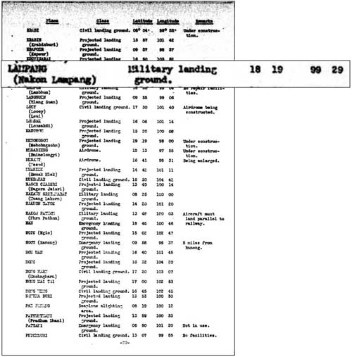
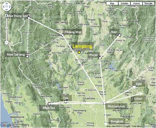
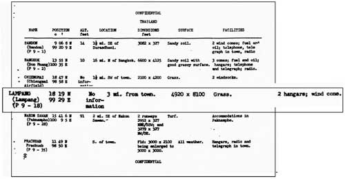
Lampang Airport: Summary Lampang became the defense center for northwest Thailand probably because it had rail, road, and air transport facilities: 1. The Royal Thai Railway had connections south to Bangkok and its commercial port, Khlong Toei. 2. The Phahonyothin Road, the main north-south road in Thailand (now Route 1) provided a comparatively good land connection to Burma: north and then northwest to Kengtung, then westward to Meiktila and Mandalay on the Irrawady River, with rail, road, and air transport connections there. 3. The Lampang "military landing ground" accessed the country's network of airfields. The alternate choice would have been Chiang Mai, which was the northern railhead for the railroad and which had its own airfield, but lacked that critical existing quality road connection north into Burma. It was also rather more off-center geographically to the other military concentrations in northwest Thailand than was Lampang. Imperial Japanese Army Air Force (IJAAF) units, early based at Lampang Airfield, flew support for Japan's successful 1942 invasion of Burma. Thereafter Lampang's importance declined as Japan's limited manufacturing base, confounded by Allied bombing, was unable to keep up with IJAAF losses and new aircraft were released direct to Japan's combat fronts in ever-decreasing numbers, and bypassing Lampang. Before the war, a US War Department report listed Lampang as a "military landing ground":[3]
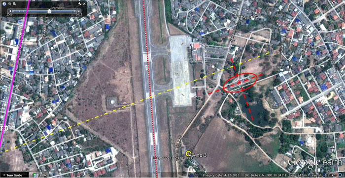
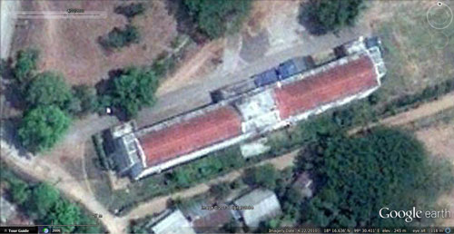
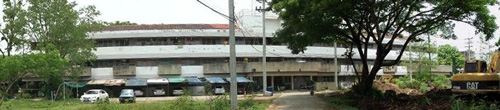
An earlier runway's orientation was approximately perpendicular to the current runway and was referred to in Allied Intelligence reports as the "original" runway.[4a] The general location of that ENE-WSW runway can be ascertained from sketches in the various Allied intelligence reports which appear in the following chronological history. That orientation is evidenced on-the-ground today primarily by a building similarly aligned to one in a 1944 aerial photo from the Williams-Hunt Collection, plus scattered details barely visible in the latter. |
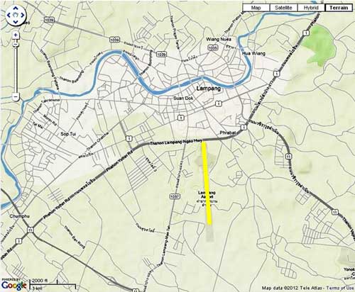
These pages were composed to be viewed best with Google Chrome. See Key for interpreting page content. Revision list. See bottom of Text column on this page. Bibliography supports notes. 1.^ Coordinates per Google Earth. 1a.^ Lampang: the spelling of this transliteration is standard throughout all references found. The name of the town has evolved over time from Lakhon (not to be confused with Lakon, aka Nakhon Sri Tammarat, south of the Isthmus of Kra), per Graham, WA, Siam: A Handbook of Practical, Commercial, and Political Information (London: Moring, 1913). To confuse matters, Wikipedia's article, Lampang, lists previous names as Wiang Lakon and Khelang Nakhon. Further confusing is the name of the next major town to the northwest and connected by rail, Lamphun. To Western eyes and ears, the similarity of the two names, both starting with L, can be frustrating. In the case of Jack Newkirk, ace Flying Tiger pilot, it may have contributed to his early death: with orders to attack Lampang in late March 1942, he instead attacked Lamphun where he fatally crashed. 2.^ Lampang is located at the junction of major Thai Highways 1 and 11. Stationing needed. 3.^ A Survey of Thailand (Siam), (Washington: US War Department, March 15, 1941), Appendix I - Airdromes, Landing Grounds, and Seaplane facilities of Thailand, v. Additional Airdromes, Landing Grounds and Seaplane Facilities of Thailand, "correct up to April 1940", p 89 (USAF Archive Microfilm Reel B1750 p1811). 4.^ "Terrain" map from Nations Online Project: Searchable Map and Satellite View of Thailand using Google Earth Data. The yellow line marks approximately 1700 m, which Allied intelligence later reported as the length of the N-S runway at Lampang. Annotation by author using Microsoft Publisher. 4a.^ Airfield Report No. 21, Apr 1944, unnumbered page (USAF archive microfilm reel A8055, p 0669) refers to the "original ENE-WSW runway". 4b.^ Google Earth Imagery date: 22 Apr 2010 4c.^ ibid, extract 4c1.^ Extracts of DSCFs 2211, 2213, & 2215 of 01 May 2014 stitched into a panorama with Microsoft Ice. Photo added to webpage 05 May 2014. |
||||||||||||||||
|
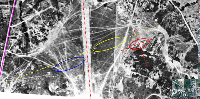
Details common to both images are tagged. The purple line on the left traces current Thai Highway No 1037. The current runway center line is shown in dotted red (that it does not match perfectly between the two images may be due to distortions in the photo or perhaps the runway was later slightly realigned). The red‑circled buildings also appear similar in the two images. The earlier runway is shown as a yellow center line. Its alignment parallels the building(s). It also parallels some obscure details on the left circled in blue. The yellow circled area denotes a long section of slightly different ground texture which is assumed to be a vestige of the old runway. A higher resolution image of the aerial photo markup may be downloaded here. The heading of that earlier runway scales as 070°-250° (07-25). Such an orientation is unusual since runways are usually aligned to take advantage of prevailing winds in the region, which have been out of the north in recent history. In fact, those winds justify the approximate north-south orientation of the current runway. When the old runway was abandoned is unclear. While that earlier runway is referred to as the "original", the Lampang airstrip was once merely a large grassy area on which aircraft could land into whatever direction the wind was blowing.[4f] |
|||||||||||||||||
|
1941 Lampang was not included in airmail routes in northwest Thailand in 1941: That Lampang had not been included in the airmail system might have been the result of its proximity to the Chiang Mai railhead, 109 km northwest by rail.[5a] Chiang Mai was also nearer to the western border towns of Mae Hong Son and Mae Sariang, which were of particular concern to the Thai government because they were among the most remote areas of the country and comparatively lawless (even into the 1970s).[5b]
Japanese aircraft, Ki-15s, were observed flying over the RAF airfield at Toungoo, Burma, at high altitude, obviously doing reconnaissance. Based in Hanoi, the flight path of the planes might have rendered them visible in various parts of Northern Thailand, including Lampang. Indeed, such aircraft might also have been observing various points throughout Thailand, including Lampang.[5c]
TRANSCRIPT:
Date uncertain, but about the same time, Christian missionaries from Chiang Mai, Nan, and Phrae traveled to Lampang from where they were bussed north to Mae Sai and crossed into Burma.[7҂]
When Field Marshal Phibun stationed army troops in the north at the beginning of the Great South East Asia War with Major General Jaroon Seri-reng-rit as northern commander-in-chief, the Royal Thai Air Force established a large air base at Lampang with Air Vice-Marshal Feun Ritakani as division commander coordinating with the army [which was also present].[7a] Royal Thai Air Force (RTAF) history records: Wing (Kong Bin Noi Phasom) 80 relocated [from Ko Kha] to Lampang, with foong bins (squadrons) gathered from other units:[7b] 22 (observation) from Chantaburi: 9 US-sourced Vought Corsair
IJAAF 10th Hikodan (area air force) under General Hirota Utaka was reassigned from Bangkok to Lampang.[8b]
|
4d.^ Extracts from: 4e.^ ibid, extract 4f.^ Earlier runway bearing was previously incorrectly stated as "170°-250° (17-25)"; corrected 05 May 2014. Original airfield configuration per Wikipedia: Aerodromes (reference needed for Lampang). 5.^ A composite of information from Young, Edward, Aerial Nationalism (Washington: Smithsonian Institute, 1995), p ix, and A Survey of Thailand (Siam), (Washington: US War Department, March 15, 1941), p 101, "Civil Air Routes (Jan 1940)", (USAF Archive Reel A2874, p 1467), superimposed on a "Terrain" map from Nations Online Project: Searchable Map and Satellite View of Thailand using Google Earth Data. Annotations by author include solid white lines per Young and dotted lines only per US War Department. See description of air mail service, Aerial Transport Co, on next page. 5a.^ Whyte, BR, The Railway Atlas of Thailand, Laos and Cambodia (Bangkok: White Lotus, 2010), pp 28-29. 5b.^ 戦没者遺骨収集の記録 ピルマ・インド・タイ [Journal on Collection of War Dead: Burma, India, Thailand] (Tokyo: All Burma Comrades Organization, 1980), p 452. 5c.^ Ford, Daniel, Flying Tigers (Washington: Smithsonian Books, 2007) p 77. 6.^ US Army Air Corps, Airports in the Far East (Washington: Intelligence Division, Office of he Chief of the Air Corps, 07 Dec 1941), p 69 (USAF Archive microfilm roll A1285 p 0073). Significance of "(P9-18)" under column heading, Name, is not known. 6a.^ Difference with data in masthead reflects lesser accuracy available in 1941, plus use of the Indian-Thailand Datum (current datum is WGS84). 6b.^ These dimensions apparently refer to a period when air facilities were simply open ground allowing aircraft to take off and land in any direction. See Wikipedia's History of Aerodromes. 7.^ From the Sheboygan (Wis) Press, Thu 18 Dec 1941, p 12: "We left on the morning of Dec 11 [from Lampang]. The sealing of the frontier cut off escape for more than 60 Americans and 200 Britons left in Thailand. The next morning [12 Dec] Japanese troops were reported to have occupied the Lamping [sic] airdrome, blocking the northern route to Burma." 7҂.^ Kneedler, William Harding, MD, Refugeeing from Thailand in World War II, unpublished manuscript dated 1943 and located in Prince Royal's College Archives, Chiang Mai. See complete text on page 7: Refugeeing. 7a.^ Translation from บุญเสิม สาตราภัย
เชียงใหม่กับภัยทางอากาศ 7b.^ Translation from บระวัติกองทัพอากาศไทย พ.ศ.๒๔๕๖ ๒๕๒๖กองทัพอากาศ พุทธศักราช ๒๕๒๖, Royal Thai Air Force Official History 1913-1983 (Bangkok: Royal Thai Air Force, 1983) [hereafter, RTAF 1913-1983], p 277. Functions and aircraft ids are from Young, ibid, pp 184‑185 with "types" defined on pp 261-262. Young records a far more complex process involving a comprehensive reorganization of the RTAF with reassignment of units to different commands and relocation of several commands to the far north of Thailand (pp 184-185). He also gives origins other than Ko Kha for the units: 22: Chantaburi J-aircraft listings differ on two out of three units from the other sources. The units it lists were all originally located at Lopburi (per Young): 21: 9 Corsairs 7c.^ RTAF 1913-1983, ibid. 8.^ The source for most of the details in the following is And for an excellent review of 77th Sentai action during this period, see: Richard Dunn's The Campaigns of the 77th Hiko Sentai. Thai military activities are presented in rather greater detail here because there are so few in-depth sources published in English. 8a.^ Dan Ford's Order of Battle 23 Dec 1941: 3rd Hikoshidan, 10th Hikodan. apparently quotes the 30 count from an order of battle dated 23 Dec 1941 presented in Japan's official military history, Senshi Sosho. However, on 04 Jan 1942, Ford records that the 77th sent out 31 Ki-27s to attack Rangoon. The 31 count, rather than the 30, is consistent with Ford's tally of losses between 23 - 27 Dec 1941: 1 loss on the 23rd and 4 on the 25th total 5. Subtracted from the original 36 leaves 31. Richard Dunn in Double Lucky? (part 2) records "about 30 [IJAAF] operational fighters" in all of Thailand at first, all from the 77th Sentai. 8b.^ Dan Ford, The January Air Battle for Rangoon.
|
||||||||||||||||