| Details of Aircraft Losses by Date |
| Text | Notes | |||||||||
|
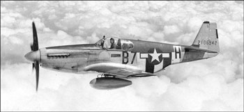
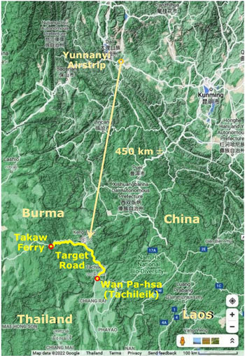
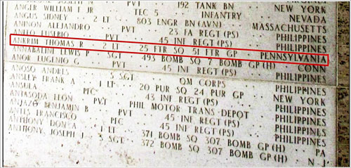
07 Dec 1944: 2LT Thomas Ankrim,[1] flying a P-51 in the 25th Fighter Squadron of the 51st Fighter Group out of Yunnanyi,[1a] hit a tree on a low altitude strafe during an "offensive road sweep" on the main transport connection between Takaw Ferry, Keng Tung, and Wan Pa-hsa. The
The road was targeted as part of a strategy to stop supplies destined for the IJA in Burma which were moving by rail from Bangkok to Lampang where they were then transferred to trucks for traveling north on the Phahonyathin Road to Mae Sai and on into Burma. The target road connected the border crossing Wan Pa-hsa across from Mae Sai to Keng Tung and on to the Takaw River bridge crossing the Salween River, a distance of about 350 km,[1b] and all part of current day Myanmar (Burma) Road No 4 leading west to Meiktila. In a P-51, flight time from Yunnanyi to the target would have taken less than an hour:[1c]
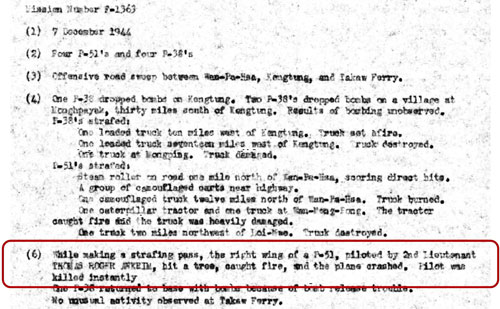
No Missing Air Crew Report (MACR) has been found for Ankrim's loss. There is, however, a report which describes the mission and his loss:[2]
Detail relevant to Ankrim includes:
Amkrim's Individual Deceased Personnel File (IDPF) has been maintained and, importantly, it includes approximate coordinates for his crash site:[2a]
But note that the coordinates are only approximations: limiting conditions include:
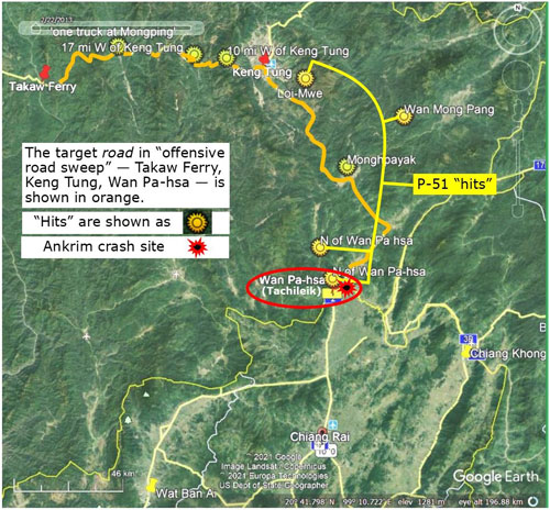
Under such conditions, accuracy suffered. But suffice to say that Ankrim crashed on the Burmese side of the border, in the vicinity of present-day Tachileik. Mapped out, the mission looked like this:[3]
Efforts by the American Graves Registration Service immediately after the war to locate his remains are unknown. At present, the Myanmar government limits access to the general area of Ankrim's crash site, and until that access is regained, there can be no further progress towards location of Ankrim's crash site and retrieval of his remains. As a consequence, his name remains included in the list of "Missing" in the Manila American Cemetery and Memorial:[4]
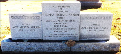
His parents long ago erected a stone in his memory in his hometown, Lancaster, Pennsylvania, USA:[5]
Afterword: A possible reason for Tachileik, or Tachilek, or Ta Kilek, as Goodden spelt it[6] (and as it is pronounced), not appearing on some Burmese maps lies in the name being the combination of the Thai words, tha and kilek, meaning pier and a tree whose leaves are used in cooking, respectively).[7] Presumably the airport had been named before a possible need to favor Burmese names, with the airport name cast in stone in the network listing for airports worldwide. References: Neither Shores nor Umemoto mention this event. The Thai Air Accidents entry for Ankrim is outdated.
|
These pages were composed to be viewed best with Google Chrome. 1.^ Photo: extracted from 1a.^ Dan Jackson, Fallen Tigers, (Lexington: University Press of Kentucky, 2021), p 173. Old Yunnanyi Airstrip: N25°25.035 E100°42.165 1aa.^ P-51 photo: FindaGrave 1b.^ A distance then of 218 miles (350 km) per The Motor Roads of Burma (Rangoon, The Burmah Oil Co, 1948), 1c.^ Extract from Google Maps, annotated by author with Microsoft Publisher.
2.^ Mission Number F-1363 of 07 Dec 1944, provided by Dan Jackson email of 1314
2a.^ Information provided by Terry Hunter email of 0642 08 Jul 2021. The IDPF is held by the Air Force Historical Research Agency (AFHRA) history of the 449th Fighter Squadron.
3.^ Extract from Google Maps, annotated by author with Microsoft Publisher. For reference, position sources: Wan Mong Pong: N21°04 E100°10 (NF 47-11, Keng Tung, 1959) Loi-Mwe: N21°10.38 E99°45.100 (NF 47-11, Keng Tung, 1959) Takaw Ferry: N21°13.16 E98°42.35 (NF47-10 Lai-Hka, 1959) Coordinates, after points located, taken from Google Earth, where possible. While two places named Wan Pa hsa appear on NF 47-15, Amphoe Mae Chan (1964), only one is near the border, at N20°26.78 E99°52.59; ie, basically in present day Tachileik, across the Mae Sai River from Mae Sai, Thailand.
4.^ FindaGrave, annotated by author using Microsoft Publisher.
5.^ Cenotaph at Chestnut Level Presbyterian Cemetery, Quarryville, Lancaster County, Pennsylvania. Annotated by author using Microsoft Publisher.
6.^ Goodden, Christian, Around Lan-Na (Halesworth: Jungle Books, 1999), 7.^ Suggested by
|
|||||||||