Japan in Northwest Thailand during World War II
| N25°26± E100°43± |
Off Topic: Yunnanyi airstrips, Yunnan, China |
Route NA |
| Text | Notes | ||||||||||||
|
In World War II, there were two US airbases in the immediate vicinity of Yunnanyi, China: Yunnanyi and Beitun. This is just an exercise to differentiate the two: Yunnanyi is about 230 km WNW of Kunming on the Burma Road. Googling Yunnanyi Airport leads to the article, Xiangyun Airport. Two Yunnanyi airfields are defined there:
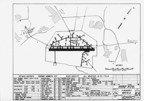
The second paragraph, however, doesn't clearly differentiate between the two. It does state that the airfield began operations in Sep 1944: presumably that was the "old" Yunnanyi Airfield. That date, however, is misleading, for Daniel Ford records Claire Chennault setting up a "primary flight school" there in 1938,[1] and the oblique aerial photo linked below, shows a "Former AVG Area". Per Daniel Jackson, about a month later, Beitun began regular use on 05 Oct 1944 with the arrival of the 22nd Bomb Squadron. G Flight, 35th Photo Reconnaissance Squadron, followed them there on 28 Oct 1944.[2] Though no coordinates are given, inputting Xiangyun Airport into Google Earth finds a clearly defined airport facility, 翔云机场 Airport, at approximately N25°26.566 E10°43.907. A second airfield is not defined. A 14th Air Force Engineering Section plan of Yunnanyi Airfield, dated 13 Jul 1944, presents a well developed facility, location: N25°26 E100°40, with housing for 244 officers, and 696 enlisted men. Curiously, the airfield dimensions are metric, though structures are in square feet and distances to obstructions are measured in feet.[3] Further, nothing resembling the plan appears in Google Earth near the location specified.
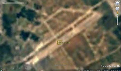
With regard to pilots based in Yunnanyi and lost over Thailand, per Jackson, 1Lt Franklin McKinney in G Flight would have flown out of Beitun when he was brought down south of Lampang by a lightning strike on 05 Nov 1944. 2Lt Henry Minco in the 25th Fighter Squadron, 51 Fighter Group, would have flown out of the older Yunnanyi airstrip when he was downed in a dogfight east of Lampang by Royal Thai Air Force (RTAF) Pilot Officer Kamrobe Pengkham about a week later, on 11 Nov 1944. The latter loss is particularly well recorded in Thai sources because it represented a RTAF win over a better equipped, more experience enemy. As such, one Thai-language website, well detailed, does show an oblique aerial photo of the older Yunnanyi airstrip: ลำปาง ยุทธเวหา (Lampang), is nicely paired with a relatively modern Google Earth satellite (vertical) view of the area, which is of sufficient resolution to allow locating the site. The website credits Yunnan China Airfields by Robert Anderson for the oblique aerial photo, used with his permission. And Anderson, in his turn, credits Mr Ge Shuya of Kunming. Shuya is a a Yunnan-based expert on World War II history who, amongst other achievements, rediscovered the Burma Road's "24-Zig" switchback road (N25°49.1 E105°12.4) in 1995. That road, signature of the Burma Road generally, is about 450 km east of Yunnanyi. I checked the location of the old airport as it appears in ลำปาง ยุทธเวหา, and It shows up in a low resolution Google Earth Historical Image dated 1985 (icon added):
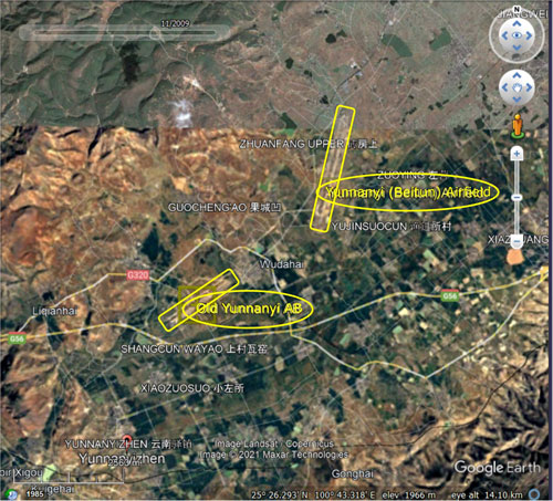
That allowed the accurate placement of the old airfield in relation to the Beitun Airport which, apparently improved though not currently used, survives to the present:
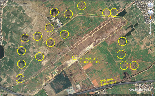
I was also curious about how many revetments were still visible. The 14th Air Force drawing shows perhaps 26 (that number depending on how one interprets the symbols on the plan). Bob Bergin visited Kunmng and Yunnanyi in 2014, and mentions in Protecting the Tiger Heritage - Kunming:
Of course, at ground level, his view of the landscape would have missed details visible from a satellite view. The image most clearly showing revetments in the area is dated 2010. Added to the image are the outline of the old airfield plus circles around visible revetments:
Revetments still visible in this view number 18.
|
This section is currently best viewed with Google Chrome. See Key for interpreting page content. Revision list. See bottom of Text column on this page. Bibliography supports notes. Coordinates are from Google Earth, unless otherwise stated.
1.^ Daniel Ford, Flying Tigers (Washington: Smithsonian Press, 2007), 2.^ Daniel Jackson, Famine, Sword, and Fire (Atglen PA: Schiffer, 2015), p 185.
3.^ Found in USAF Archives, Maxwell Air Force Base, and provided by Daniel Jackson, email of 10:54 05 Nov 2018.
| ||||||||||||


