| N18°36 E98°49 | Ban Kat (Th: บ้านกาด / Jp: バンガート村 ) page 2 of 8 |
Route 1013 |
|
Satellite view of Ban Kat area [10a] (circled numbers are "clickable" to references in text following):
|
|
|
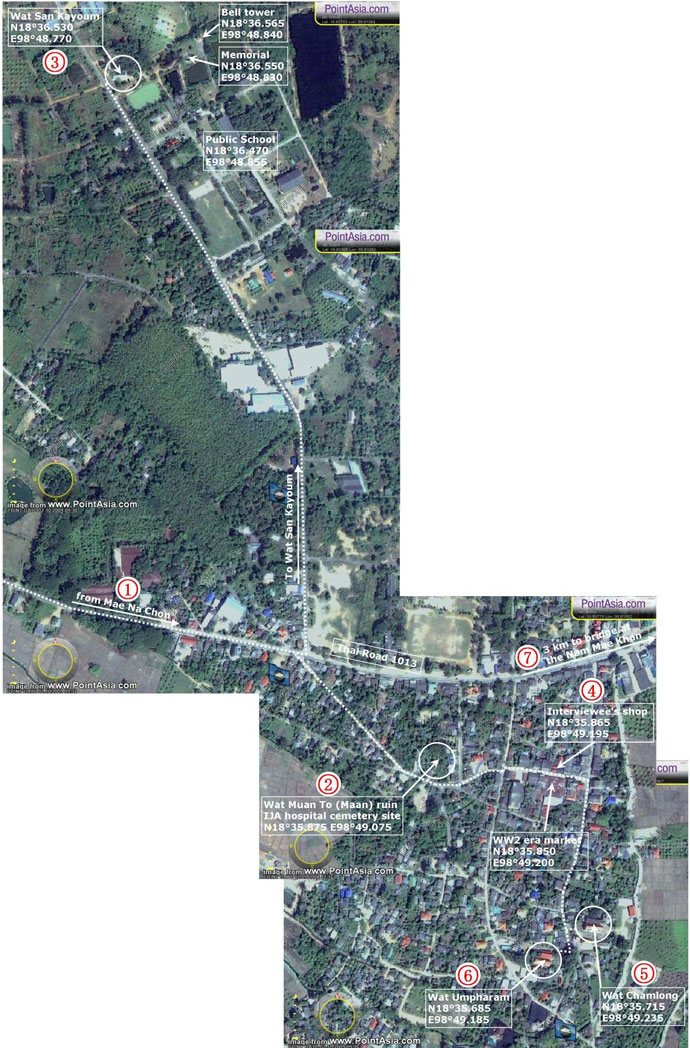
From Khun Yuam, 99 km west of Ban Kat,[11] a few high-ranking officers rode in on horses;[11a] but most soldiers walked. No one came by motor vehicle: road conditions were, in most instances, nothing more than paths. Vehicle fuel was simply not available between Kemapyu in Burma and Ban Kat: some vehicles by virtue of fuel siphoned from stalled vehicles managed to get as far as the Khun Yuam area.[12] For transport around Khun Yuam, some vehicles had been converted to steam, fueled by wood or coal.[13] From Khun Yuam, Japanese soldiers arriving at Ban Kat would have last passed through Mae Na Chon[13a] (Map Point 1). There was no mention of self-powered vehicles operating in Ban Kat. Coming into Ban Kat, soldiers were to report to Wat Maan[13b] for medical evaluation and then assignment to quarters (Map Point 2). The ruins of Wat Maan can still be seen through the heavy foliage (Map Point 2):
Because of their large numbers, however, control was difficult and some soldiers never "reported in", but just wandered into the various living facilities. Soldiers stayed not only at the wats, but also in innumerable tents scattered throughout the Ban Kat area. Some troops were sent 1.6 km north to the ruins of Wat San Kayoum[15a], though the ruins themselves would have provided no shelter (Map Point 3):
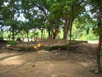
(Map Point 3)[16] More typically, soldiers wandering into Ban Kat, went on past Wat Maan and Komloo's house/store[16a] (Map Point 4), and turned south to Wats Chamlong[16b] (Map Point 5) and Umpharam[16c] (Map Point 6) to overnight. Both Wat Chamlong and Wat Umpharam survive and prosper today:
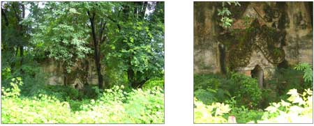
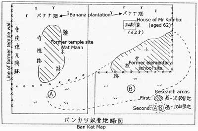
There were no civilian medical facilities in Ban Kat, and apparently only a very rudimentary clinic set up by the IJA at the ruin of Wat Maan. Soldiers who died around Ban Kat were buried in the area of Wat Maan which extended to include the current residence of a Mr Kamboi. See map sketch below:
Very little is known about Wat Maan (earlier rendered Wat Muai To[19a]), other than both its names mean 'Burma' in the Taiyai and Burmese languages; this refers to the nationality of the monks who established it. Superstitious local residents avoid the area for all the potential spirits that might reside there. Mr Komboi is apparently not superstitious. About three kilometers east of Ban Kat, motor vehicles were available for transport to Chiang Mai at the Nam Mae Khan (the Khan Stream)[20] (Map Point 7). No structure capable of supporting motor vehicles bridged the stream at that time. Fuel for those vehicles would have been transported by rail from the Bangkok area to Chiang Mai.
|
10a.^ Mosaic of PointAsia views of Ban Kat area, accessed 05 Sep 2008. Annotations by author. Google Earth coverage was substantially inferior in resolution in 2009; in Mar 2012, resolution is satisfactory, but Google Map imagery suffers from a peculiar color washout. 11.^ 戦没者遺骨収集の記録 11a.^ Interview with Kamroo, 12.^ 井上 朝義 (えのうえもとよし),彷徨ビルマ戦線(山口県防府市: 13.^ ชมธวัช, เชิดชาย, บ้อมูลเส้นทาง เดินทัพทหารญี่ปุ่นในอำเภอบุนยวม 13a.^ N18°43.87 E98°28.60 13b.^ N18°35.875 E98°49.075 14.^ Author photo: CIMG3657a.jpg, 09 Sep 2008 15.^ Author photo: CIMG3658a.jpg, 09 Sep 2008 15a.^ N18°36.530 E98°48.770 16.^ Author photo: CIMG3644a.jpg, 12 Sep 2008 16a.^ N18°35.865 E98°49.195 16b.^ N18°35.715 E98°49.235 16c.^ N18°36.685 E98°49.185
17.^ Author photo: CIMG3654a.jpg, 09 Sep 2008 18.^ Author photo: CIMG3646a.jpg, 09 Sep 2008
19.^ Journal, p 453 with annotations by author. 19a.^ The name was also applied to Mae Hong Son town from 1917 to 1938. See Note 2 in Mae Hong Son.
20.^ N18°36.664 E98°50.862
|