| N18°21 E99°25 |
Hang Chat Landing Ground (Th: ห้างฉัตรท่าอากาศยาน / Jp: ハンチャツ滑走路) Lampang Province Page 1a of 3 |
near Hang Chat RR Station on Northern Route Sta 654.85 |
| Text | Notes |
|
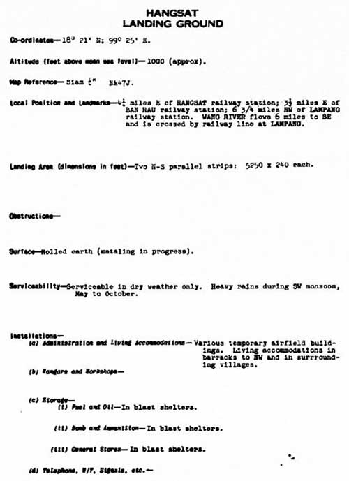
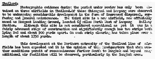
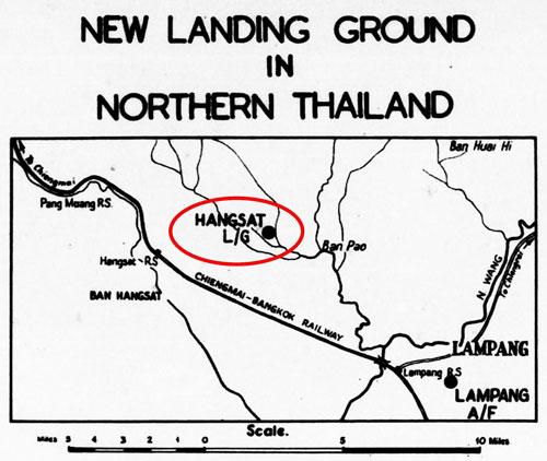
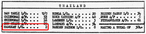
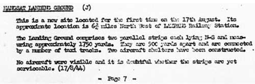
Discovery of a Japanese Army air facility under construction at Hang Chat was first announced by Allied intelligence in August 1944. The Allied unit providing the "photographic evidence", presumably a photographic reconnaissance squadron (PRS), was not identified.[2å] TRANSCRIPT (smoothed, comments and emphasis added):[2β] Thailand: Photographic evidence during the period under review [presumably August 1944] has only been obtained on three airfields in Thailand. Of these [Chiang Mai] and Lampang were observed to be undergoing considerable development in the form of increased dispersal, surfacing, and general maintenance. The third site is a new airfield, now officially named [Hang Chat] Landing Ground, located 6¾ miles northwest of Lampang Railway Station. Although this site is not considered operational as yet, it was in a fairly advanced stage of construction and significantly enough has two strips both lying N-S and about 900 yards apart. On each strip, clearing has taken place over a length of about 1750 yards. This development at the northern extremity of the Thailand line of airfields has been expected and it is the opinion of this Headquarters that, when weather conditions permit reconnaissance further south to Bangkok and beyond, many additional air facilities will be observed, particularly in the Bangkok area.
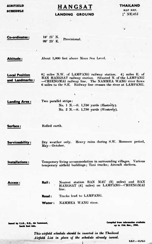
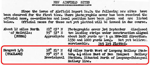
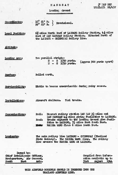
This section added approximate coordinates: TRANSCRIPT of description: 6¾ miles northwest of Lampang Railway Station, 4¼ miles east of Ban [Hang Chat] Railway Station. Situated north of Lampang-[Chiang Mai] Railway line.
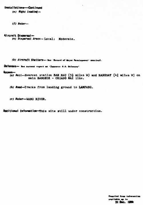
And provided the following additional facts: • The title ends with (J), indicating that Allied intelligence believed • The information was obtained on 17 August. • The last paragraph clarified: "No aircraft were visible and it is
Note that distances and approximate bearings from three points are given: • 6¾ miles northwest of Lampang railway station The last station named, Ban Bau (?), does not match any currently listed station. However the other two exist, and specified radii intersect at a point about two miles east-northeast of the location as finally determined in the 16 March 1945 sketch shown on the next page. Though its easterly runway never became serviceable, Hang Chat was planned to have a configuration different from other airstrips in northwest Thailand: it was to have two approximately parallel runways separated by about 400 yards (365 m). An insight into the logic of this approach, a multi-runway air facility, was offered in the September 1944 Airfield Report: Relevant text of above (emphasis added): . . . the Japanese considered that single strips were a sufficient provision so long as they had reason to believe that the Allies could not wage an offensive campaign from the air supported by the threat of ground forces. At the present time, however, the enemy have been forced to accept the challenge of the growing Allied strength in this theatre, and the measures taken by them have assumed several novel aspects. The multiple strip airfield is one of them. It has been described as taking the form of two or more strips or runways sited some distance apart but incorporated within an extensive network of taxi tracks and dispersal areas. Generally speaking the direction of those runways or strips is more or less common to each individual site, for instance at Myingyen 2 strips are aligned N-S and one NNW-SSE, while at Laihka the three strips veer from NNW-SSE to NE-SW. The significance of this is that they are not aligned in order that landing facilities may be available in a variety of wind directions but are intended for simultaneous employment for one or a combination of the following reasons: (a) The operation of a large number of aircraft at one time (b) In order to ensure that, under any period of sustained (c) To provide an additional insurance against concentrated
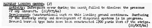
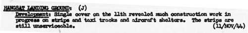
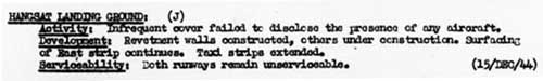
Text (smoothed): [Hang Chat] Landing Ground (J) Activity: Infrequent cover during the month failed to disclose the presence of any aircraft. (22 Oct 1944) Development: Construction work on this landing ground continues. Surfacing of the easterly strip and development of dispersal systems is in progress. Several barracks type huts have been constructed 1700 yards west of the strips. (22 Oct 1944)
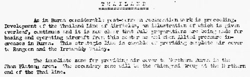
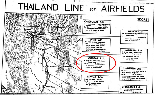
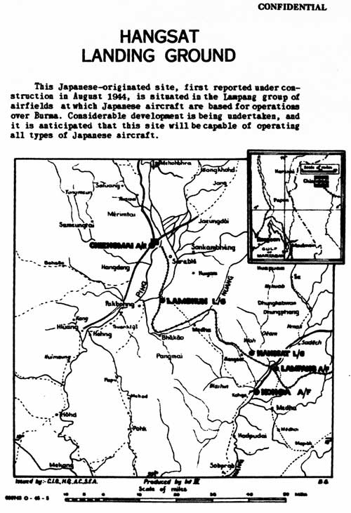
Text of above (smoothed): Thailand: As in Burma considerable post-monsoon reclamation work is proceeding. Development of the Thailand Line of Airfields, an illustration of which is given overleaf [see below], continues and it is now clear that full preparations are being made for basing and operating aircraft from this sector as and when Allied pressure increases in Burma. This strategic line is capable of providing complete air cover to Rangoon and the Irrawaddy Valley. The immediate zone for providing air cover to Northern Burma is the Shan Plateau area. The secondary zone will be the [Chiang Mai] Group at the Northern end of the Thai line. Text circled above (smoothed): Hangchat Landing Ground • 2 Strips. North-south. 1750 & 1750 yards. Rolled earth.
Items of significance that were updated: • Clarification of the facility's limitation weather-wise: • Various "temporary airfield buildings" had been erected. • Clarification of the name of the unknown railway station,
|
2å.^ The unit would apparently not have been the 21PRS for which flight records are available (and presented here as applicable). 2b.^ Airfield Report No. 25, Aug 1944, "Comments on Current Airfield Development", p II Because of the quantity of information provided in this airfield report which introduces Hang Chat, its sequence has been changed from page number to time-ordered. Undated material is presented first, with dated material following, in chronological order. 2β.^ Texts are occasionally transcribed herein when there are complaints about illegibility. Spelling of locations generally reflects current usage.
2c.^ Airfield Report No. 25, Aug 1944, "New Airfield Sites", p VI
2d.^ Airfield Report No. 25, Aug 1944, "Japanese Enemy Airfields", unnumbered page (USAF Archive microfilm reel A8055 p0855).
2e.^Airfield Report No. 25, Aug 1944, "Aircraft Shelters", p VI
2f.^ Airfield Report No. 25, Aug 1944, "Record of Airfield Activity and Development", p 7 (USAF Archive microfilm reel A8055 p0862).
2g.^ Airfield Report No. 25, Aug 1944, unnumbered page (USAF Archive microfilm reel A8055 p0880).
2h.^ Airfield Report No. 26, Sep 1944, "Multiple Strip Airfields", p (iii)
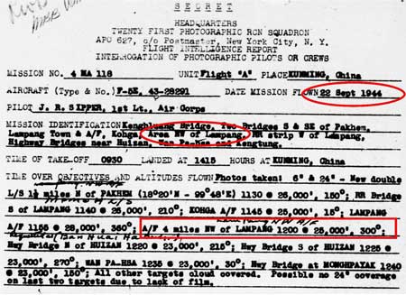
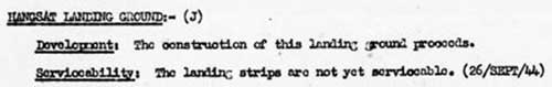
3.^ 21st Photographic Reconnaissance Squadron (hereafter 21PRS) Report Mission No. 4 MA 118, 22 Sep 1944 (USAF Archive microfilm reel A0878 p0476). The flight reports here record aerial photo coverage of Hang Chat Airstrips (Hangsat Landing Ground) by only the 21st Photographic Reconnaissance Squadron (21PRS). Other coverage probably exists, but it does not appear to have been released to this point in time. Reports aside, no WW2 era photos of the facility have been found as yet (other than the extremely poor quality mimeographed (?) copy published on 31 January 1945and shown on the next page). 3a.^ Airfield Report No. 26, Sep 1944, "Record of Airfield Activity and Development", p 10 (USAF Archive microfilm reel A8055 p0988).
3b.^ Airfield Report No. 27, Oct 1944, "Record of Airfield Activity and Development", p 9 (USAF Archive microfilm reel A8055 p1019).
3β.^ Airfield Report No. 27, Oct 1944, "Comments on Current Airfield Development", "Thailand", p ii (USAF Archive microfilm reel A8055 p0998). The "Chiang Mai Group" is nowhere else defined.
3c.^ Airfield Report No. 27, Oct 1944, "Thailand Line of Airfields", unnumbered page (USAF Archive microfilm reel A8055 p0999).
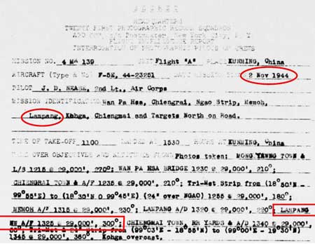
4.^ 21PRS Report Mission No. 4 MA 139, 02 Nov 1944
4a.^Airfield Report No. 28, Nov 1944, "Record of Airfield Activity and Development", p 8 (USAF Archive microfilm reel A8055 p1133).
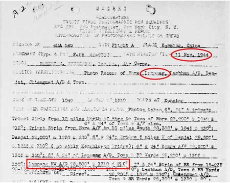
5.^ 21PRS Report Mission No. 4 MA 140, 11 Nov 1944
5a.^ Airfield Report No. 28, Nov 1944, "Thailand Line of Airfields", unnumbered page (USAF Archive microfilm reel A8055 p1088).
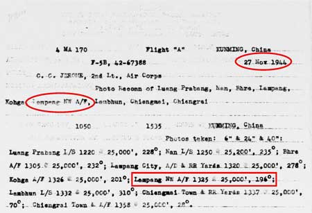
6.^ 21PRS Report Mission No. 4 MA 170, 27 Nov 1944
6a.^Airfield Report No. 29, Dec 1944, "Record of Airfield Activity and Development", p 7 (USAF Archive microfilm reel A8055 p1181).
6b.^ Siam (Thailand) List of Airfields and Seaplane Stations, (Washington: GPO, 1945), unnumbered pages (USAF Archive microfilm reel A1285 p1157).
|
-Hangchat-CNX.jpg)