Japan in Northwest Thailand during World War II
| N18°25 E99°44[1] |
Mae Mo[1a] Landing Ground (Th: ท่าอากาศยานแม่เมาะ / Jp: マイモ滑走路) Lampang Province Page 1 of 4 |
Thai Route 0001 Sta 000.00 [2] offset 0.8km south |
| Text | Notes |
|
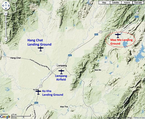
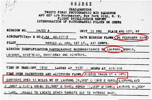
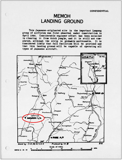
Mae Mo: Summary Mae Mo Landing Ground was the easterly satellite air facility in the Lampang Airfield Group of the Imperial Japanese Army Air Force (IJAAF). The facility's two runways, the better developed one running NNE-SSW, and the other N-S, formed an "X". It was located approximately 31 km by air northeast of Lampang Railway Station (the reference point used by Allied intelligence during WW2), and about 28 km by air from the Lampang runway. Constructed by the Japanese in 1944-1945, no aircraft was ever observed there. There is evidence on the ground and in local oral history of at least one effective Allied targeting of the facility. After the war, surrounding forests which best defined the runways were cut down, with the runways themselves almost disappearing into the rice field panorama that now covers the immediate area. Aerial photo flight reports below record coverage of Mae Mo Airstrips (Memoh Landing Ground) by only the 21st Photographic Reconnaissance Squadron (21PRS). Other coverage probably exists, but records seem not to have been released as yet. No WW2 era photos of the facility have been found either (other than the extremely poor quality mimeographed (?) copy published on 11 November 1944 and shown below, and republished in January 1945 as seen on the next page). 21PRS, based in Kunming, China, was one Allied unit that made aerial photographs of features in Thailand. The Mae Mo airstrip was about 800 km (500 mi) SSW of Kunming. One of the areas targeted in this aerial photo request below was not named, but the only site anywhere close to the specified 13 miles (21 km) northeast of Lampang was Mae Mo, which was actually about 19 miles (31 km) away (as measured to the Lampang railway station):
In a comprehensive table published in January of the next year about the Lampang Airfield Group --- of which Mae Mo was a part --- the Mae Mo air facility was recorded as having been first observed on 25 April 1944. Curiously the April date was about two months after the two reports above were dated. No explanation has been found for the later use of the April date.
341st BG unit records describe a task assigned to the 22nd Bombardment Squadron as Mission B247, that of bombing the Kaeng Luang Railway Tunnel (assumed to have been the Huai Mae Lan tunnel):[4b] 19 Jun 44 – Four 22nd B-25s took off from Yangkai at 0700 hours to attack the Kenghluang Railway Tunnel, Thailand --- All planes succeeded in reaching the Kenghluang Railway Tunnel, which was observed through breaks in the clouds. These breaks, however, were neither sufficiently large nor frequent enough to permit a bomb run. . . . Planes 43-3617 and 43-3958, after repeated attempts, finally located a break (in the clouds) and spotted an airfield having two runways crossing in an 'X' pattern. These two planes dropped all bombs on the airfield but results were completely obscured by the cloud overcast. . . . In the north of Thailand, there was only one "X" pattern airfield: Mae Mo, and the current rice paddy terrain at the former site still displays bomb craters. Ironically Allied reconnaissance never observed any aircraft there. Note that the "X" pattern had not been designated for bombing, but had become a target only by accident. Lampang's other two satellite airfields, Hang Chat and Ko Kha were never attacked.
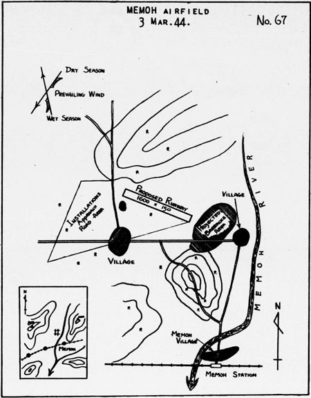
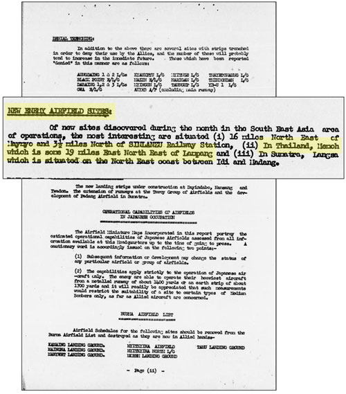
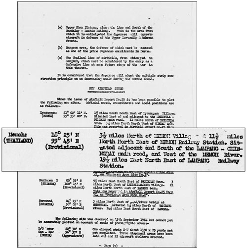
Here, Allied Intel labeled Mae Mo as one of the three "most interesting" newly discovered sites "during the month" in Southeast Asia, and it was accurately located 19 miles ENE of Lampang (railway station) --- while billed as "newly discovered" this month (presumably September), recall that the sketch just above was dated six months earlier:
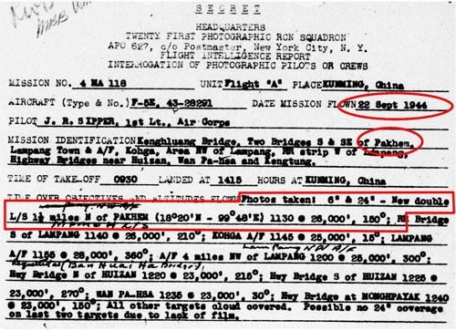
Four days later there was a photo order that included two bridges south and southeast of Pakhem.[6a] The coordinates for Pakhem are provided in the order and place it 12 km (8 mi) southeast of the Mae Mo air facility. No photo information for the targeted bridges is described in the results. The results do describe "double L/S" (landing strips) nearby Pakhem and there is only one air facility in the area with such a configuration: Mae Mo.
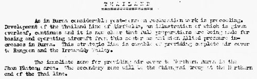
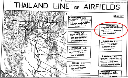
Text of above (smoothed): Thailand: As in Burma considerable post-monsoon reclamation work is proceeding. Development of the Thailand Line of Airfields, an illustration of which is given overleaf [see below], continues and it is now clear that full preparations are being made for basing and operating aircraft from this sector as and when Allied pressure increases in Burma. This strategic line is capable of providing complete air cover to Rangoon and the Irrawaddy Valley. The immediate zone for providing air cover to Northern Burma is the Shan Plateau area. The secondary zone will be the Chiang Mai Group at the Northern end of the Thai line. Text circled above (smoothed): Mae Mo Landing Ground • Airstrips of rolled earth are under construction. On 25 October 1944, an attempt to photograph Memoh A/F was unsuccessful due to cloud cover:
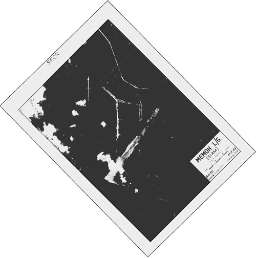
11 November 1944: The first aerial photo of Mae Mo was published, but was of such poor quality as to be unusable, at least now. It has here been reoriented so that photo north points to the top of this webpage:
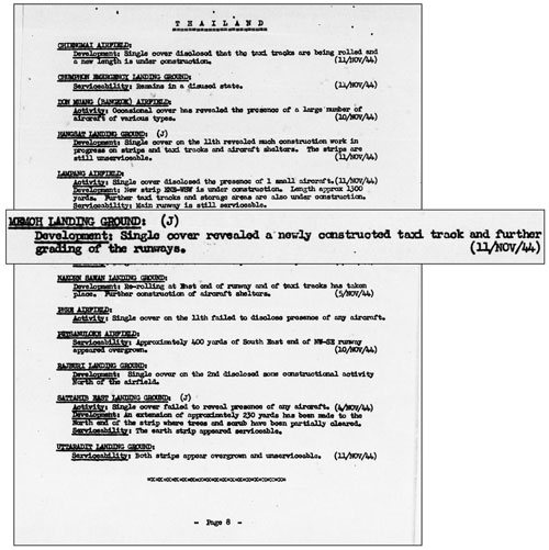
And an interpretation on the same date noted evidence of continued construction:
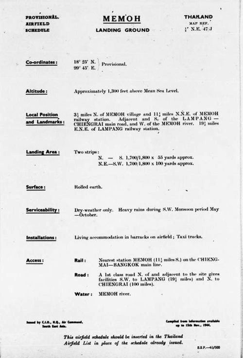
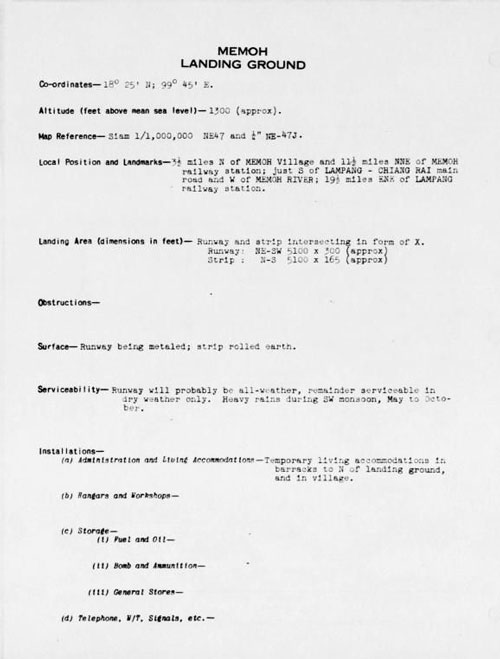
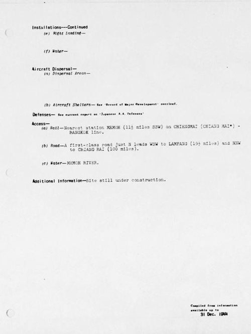
TRANSCRIPT: Coordinates --- 18°25'N; 99°45'E
|
These pages were composed to be best viewed with Google Chrome. See Key for interpreting page content. Revision list. See bottom of Text column on this page. Bibliography supports notes. 1.^ Source: Combination of GPSs from site visit and Google Earth. 1a.^ During WWII: "Memoh". Uncommonly, "Memeh". As an administrative district in Lampang Province, Mae Mo covers almost a thousand square kilometers. The name is best known as that of the Mae Mo open pit (opencast) lignite mine with the largest electrical generation facility in the north located next to it. A subdistrict and a railway station carry the same name and are near the power plant. This all proved very confusing in trying to locate the IJAAF Mae Mo airstrip, until Allied intelligence maps pinpointed its location, well north of that collection of names. More correctly, it is in Ban Ta Sri, Tambon Ban Dong, Amphoe Mae Mo. Note: not listed in Air America's Air Facilities Data Thailand 432, 1971. 2.^ By author inspection 3.^ "Terrain" map from Nations Online Project: Searchable Map and Satellite View of Thailand using Google Earth Data. Annotation by author using Microsoft Publisher.
3a.^ 21st Photographic Reconnaissance Squadron (hereafter 21PRS) Report Mission No. 14/23A, 26 Feb 1944 (USAF Archive microfilm reel A0878 p0118). There was more than one Allied unit charged with aerial photography over Thailand, but the only order sheets found to date are those from the 21PRS. A short explanation of aerial photograph orders is at USAAF Aerial Photographic Intelligence.
4.^ Plans of Airfields in French Indo-China and Siam (Publication No. 3.II)
4a.^ Detail for 19 Jun 1944 added 11 Apr 2015.
4b.^ Courtesy of Tony Strotman (mgr, website,
5.^ Airfield Report No. 26, Sep 1944,
6.^ Airfield Report No. 26, Sep 1944,
6a.^ Pakhem no longer exists --- it was absorbed by the sprawling Mae Mo lignite surface mine whose product powers the Mae Mo Power Generation Plant. However, somewhat humorously, both mapquest (at N18°20.13 E99°43.90) and Satellite Views (at N18°20.15 E99°43.92) list the location. The coordinates compare reasonably well with the photo order's N18°20 E99°48. The latter source further describes Pakhem as a "City or Community: Populated place". 6b.^ 21PRS Report Mission No. 4 MA 118, 22 Sep 1944 (USAF Archive microfilm reel A0878 p0476).
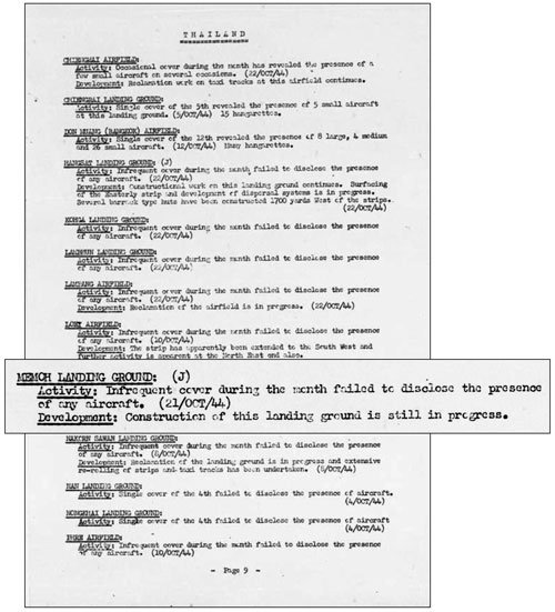
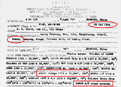
7.^ Airfield Report No. 27, Oct 1944, Note that the last 21PRS photo mission over Mae Mo was dated 22 September 1944. The comment about "infrequent cover during the month" would appear to have spurred subsequent pointed efforts on 25 Oct, 01 Nov, and 02 Nov to photograph the site.
7α.^ Airfield Report No. 27, Oct 1944, "Comments on Current Airfield Development", "Thailand", p ii (USAF Archive microfilm reel A8055 p0998). The term "Chiang Mai Group" in reference to WW2 airfields appears nowhere else in the literature. Its meaning is unclear.
7å.^ Airfield Report No. 27, Oct 1944, "Thailand Line of Airfields", unnumbered page (USAF Archive microfilm reel A8055 p0999).
7a.^ 21PRS Report Mission No. 4 MA 132, 25 Oct 1944 (USAF Archive microfilm reel A0878 p0551).
8. (deleted).
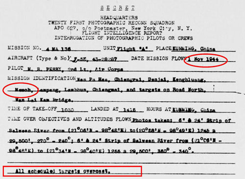
9.^ 21PRS Report Mission No. 4 MA 136, 01 Nov 1944 (USAF Archive microfilm reel A0878 p0567).
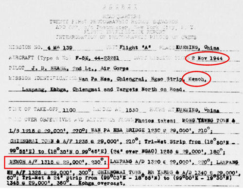
9a.^ 21PRS Report Mission No. 4 MA 139, 02 Nov 1944
10.^ Airfield Report No. 31, Feb 1945, "Memoh L/G" (dated 11 Nov 1944), unnumbered page
11.^ Airfield Report No. 28, Nov 1944, "Record of Airfield Activity and Development", p 8 (USAF Archive microfilm reel A8056 p1133).
11a.^ Airfield Report No. 28, Nov 1944, "Memoh Landing Ground", unnumbered page (USAF Archive microfilm reel A8055 p1081).
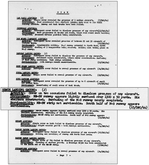
12.^ Airfield Report No. 29, Dec 1944, "Record of Airfield Activity and Development", "Siam"
13.^ Siam (Thailand): List of Airfields and Seaplane Stations, "Memoh Landing Ground", (data dated to 31 Dec 1944) unnumbered page (Washington DC: Office of Assistant Chief of Air Staff, Intelligence, 1945)
|