Japan in Northwest Thailand during World War II
| USAAF Aerial Photographic Intelligence |
| Text | Notes |
|
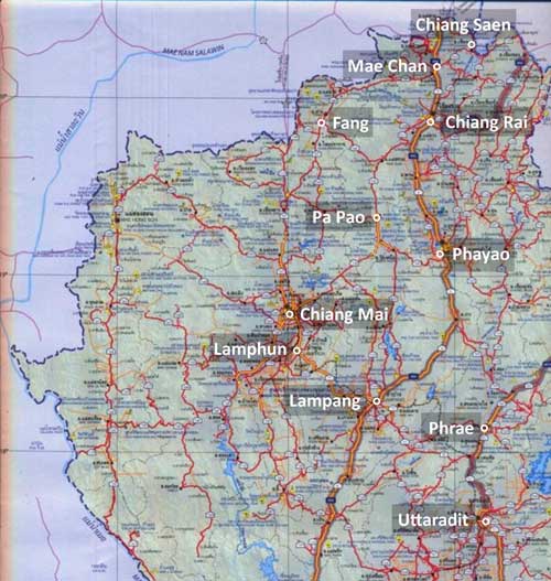
This page discusses aerial photographic intelligence found in US Government archival systems.[1] In northwest Thailand, the following general areas are reported to have been covered by aerial photo surveillance per flight records of Photographic Reconnaissance Squadrons (PRS) in the US Army Air Force (USAAF):[2] This section presents aerial photo flight records from those PRSs. Currently only flight reports are displayed, not matching aerial photos. If corresponding photos are discovered, they will be added to this page. This discontinuity exists because the two items are separately maintained: Flight records are maintained by the US Air Force Historical Research Agency (AFHRA) at Maxwell Air Force Base in Montgomery, Alabama; this agency is the primary source via CD copies. In addition, some commercial websites offer limited selections, apparently obtained from AFHRA. Aerial photos are apparently maintained by the US National Archives and Records Administration through the Department of Defense at various US Army facilities, On-line access to catalogues seems unreliable.[3] Secondary sources seem to be currently one, with excellent quality, though very limited selection: Fold3. Locations in northwest Thailand covered by USAAF photo reconnaissance include:
Ban Dara Bridge For asterisked topics (* and **), aerial photo flight records were integrated with all other information available about the subjects.
The following may appear confusing because I don't yet have a specific example of an aerial photo flight report that matches an actual photo in hand. But I include it nonetheless to record how to interpret some of the identifying information provided on some aerial photos. The abbreviation, "PR" or "PRS", in the handwritten annotation on an aerial photo is an abbreviation for Photographic Reconnaissance / Squadron, an organizational unit in the US Army Air Force (USAAF). It will typically be preceded by a number identifying the particular squadron; eg, 9, 35, 40, etc. The photos for one of the aerial mosaics presented for Lampang (here) have these "identifiers" in the upper left corners. Note that these all attribute 40PRS:[7]
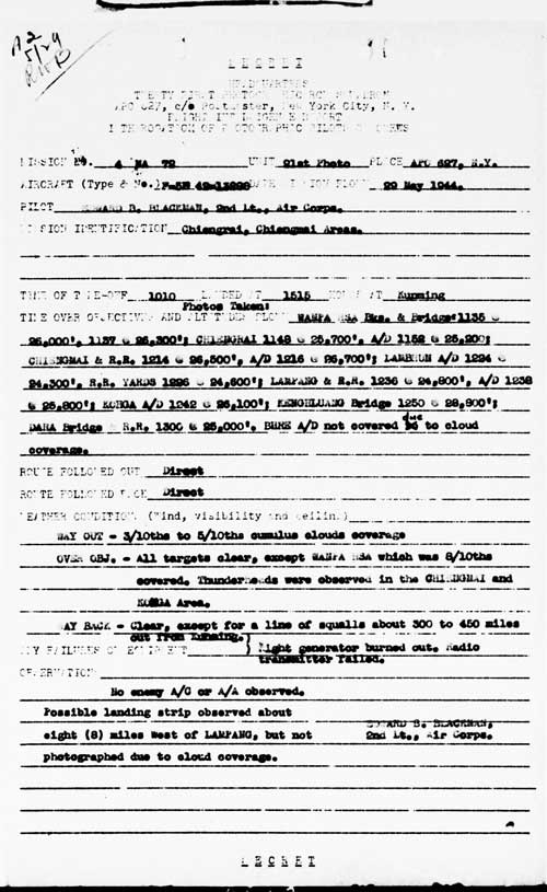
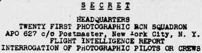
A typical USAAF aerial photo flight report from a different flight looks like this (I can find no photo requests which match the ID numbers above nor even a PRS aerial photo request from 40PRS): As noted above, the three "identifiers" from actual aerial photos show "40 PR" in the heading of the report; but no aerial photo requests from 40PRS have been found. As a result, a heading from a different PRS, in this case "TWENTY FIRST PHOTOGRAPHIC RCN SQUADRON", or "21PR", or 21PRS is shown as an example: The key item in the flight report above is "MISSION 4 MA 72": This corresponds to "5 M 135" seen in the annotations illustrated above; ie, that was the mission number on which the photos were snapped. As a result, unfortunately, without matching mission reports, USAAF aerials are otherwise unidentifiable. To this point, the following PRS designations are known to have functioned over Thailand: PRS 9[9a]
While I have not yet found equivalent reports by the RAF, I can note that annotations on its aerial photos at least include dates. Typical example:
The term, TRI-MET, appears frequently in aerial photo reports and is an abridgement of Trimetrogon. This is a "system of aerial mapping involving the use of a single assembly containing three cameras with which one vertical and two oblique right and left aerial photographs are taken simultaneously at regular intervals over the area being mapped".[11]
|
This section is currently best viewed with Google Chrome. See Key for interpreting page content. Revision list. See bottom of Text column on this page. Bibliography supports notes. 1.^ Note that the current main source of actual aerial photographs of Thailand during WWII is the Williams-Hunt Aerial Photograph Digital Collection, most of which appears to be RAF in origin and is treated in some detail on this website at: 2.^ Per the US Air Force Historical Research Agency. Aerial photo unit records covering northern Thailand are currently limited to 21PRS starting in January 1944 (part of the unit was assigned on 12 Jul 1943 to Kunming from where it would have provided coverage of Thailand (see "21st Photographic Reconnaissance Squadron" at CBI Order of Battle). One set of photos in the Williams-Hunt Collection are credited to 40PRS (see below). 2a.^"Terrain" map from Nations Online Project: Searchable Map and Satellite View of Thailand using Google Earth Data. Annotation by author using Microsoft Publisher.
3.^ Last accessed on 05 Dec 2012.
4-6. (deleted)
7.^ Williams-Hunt Collection aerial photos of Lampang are shown here. For 1945, 40PRS flew F-5 aircraft based at the following locations in India starting at the dates shown: •(09 Aug 44): Alipore Source: US Army Air Force 1st-49th Squadrons 1941-1945. See also Combat Squadrons of the Air Force World War II, 40th Photographic Reconnaissance Squadron (p 188). 7a.^ 21st Photo Squadron aerial photo flight report of 29 May 1944 (USAF archive microfilm reel A0878, p 10). 21st Photographic Reconnaissance Squadron(History and Lineage). Combat Squadrons of the Air Force World War II, 21st Photographic Reconnaissance (p 169).
8.^ ibid, heading extracted.
9.^ ibid, "Mission No." and "Unit" extracted.
9a.^ PRS 9: Wikipedia notes that unit operations included Thailand. No flight records available from USAF archives. See also 9th PRS (added per email comment by Matt Poole 12 Dec 2014). 9b.^ PRS 21: Numerous flight records available on USAF archive microfilm reel A0878. 9c.^ PRS 40: Aerial photo margin annotations show unit operations included Thailand. Wikipedia 8th Reconnaissance Group lists unit. 10.^ Extract from 02538.jpg (RAF-LPG-2538-ID.jpg).
11.^ Merriam-Webster.
Redo photomosaics, creating geotiffs with Quantum GIS Lisboa and then joining them using US Army Corps of Engineers' HyperCube or Racur's PhotoMod.
|