Japan in Northwest Thailand during World War II
| N18°34.06 E99°02.48[1] | Lamphun[2] Airstrip (Th: ทางวิ่ง ลำพูน / Jp: ランプーン 滑走路 ) page 1 of 6 |
Route 0011 |
| Text | Notes | |||||||||||||||
|
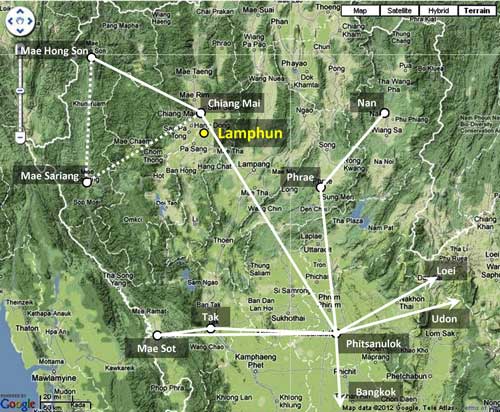
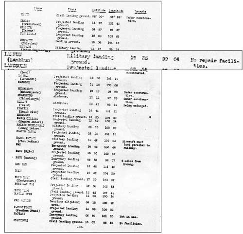
But, while Lamphun was not tied into Thailand's Aerial Transport Co airmail network,[3a] the airstrip was recorded as existing prior to World War II: A US War Department report listed Lamphun (Lambhun) as a "military landing ground" with "no repair facilities":[4]
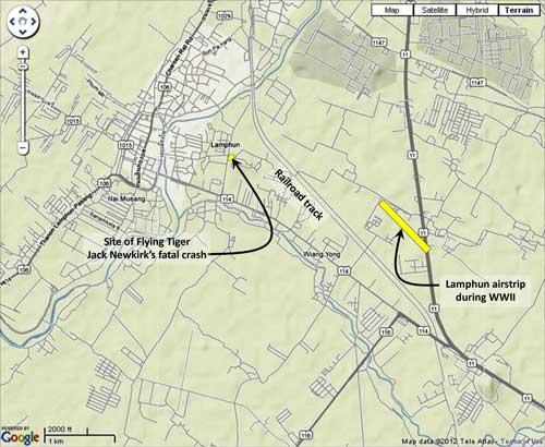
When it was constructed has not been determined. It was located east of Lamphun town:[5]
Royal Thai Air Force (RTAF) histories record that a tactical fighter unit composed of three Curtiss Hawk III biplanes was relocated to Lamphun.[5a]
|
See Key for interpreting page content. Revision list. See bottom of Text column on this page. Bibliography supports notes. 1.^ Since the airstrip no longer exists, and no evidence of it is now visible in a landscape largely resculpted by construction of a major highway through the area, coordinates are per best information applied to Google Earth. See annotated aerial photos and discussion below. 2.^ Lamphun: also rendered Lambhun, Lambohn, Lambahn, Lampoon, etc. Because of its similarity in Western spelling and pronunciation to Lampang (a city 60 air-km to the southeast of Lamphun), the two have always been confused. It was a possible factor in Flying Tiger Jack Newkirk's failure to fly to Lampang, his designated target, before his fatal crash. See: Bergin, Bob, "Flying Tiger, Burning Bright", Aviation History, July 2008, p 30. 2a.^ Stationing needed. 3.^ The map is a composite of information from Young, Edward, Aerial Nationalism (Washington: Smithsonian Institute, 1995), p ix, and A Survey of Thailand (Siam), (Washington: US War Department, March 15, 1941) p 101, "Civil Air Routes (Jan 1940)", (USAF Archive Reel A2874, p 1467), superimposed on a "Terrain" map from Nations Online Project: Searchable Map and Satellite View of Thailand using Google Earth Data [herafter, Nations Online]. Annotations by author using Microsoft Publisher show solid white lines per Young and lines unique to US War Department as dashed. 3a.^Young, ibid, pp 80-84, 101. 4.^ A Survey of Thailand (Siam), (Washington: US War Department, March 15, 1941), Appendix I - Airdromes, Landing Grounds, and Seaplane facilities of Thailand, v. Additional Airdromes, Landing Grounds and Seaplane Facilities of Thailand, "correct up to April 1940", p 89 (USAF Archive Microfilm Reel B1750 p1811). 5.^ ibid. Annotations by author based on Airfield Report No. 21, Apr 1944, aerial photo "Lambhun L/G", unnumbered page (USAF Archive microfilm reel A8055 p 657) and overlaid on a "Terrain" map from Nations Online, ibid. (Annotated aerial photo available as November 1943 entry here) 5a.^ บระวัติกองทัพอากาศไทย The Curtiss Hawk model is identified as "III" in Young, ibid, pp 184-185. |
|||||||||||||||


