| N18°21 E99°25 |
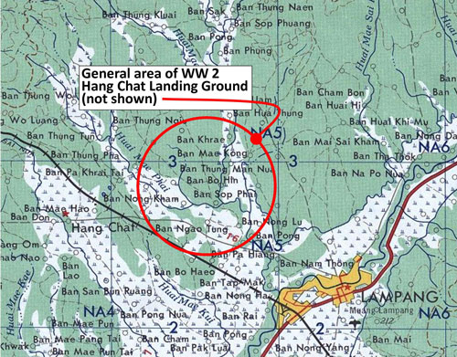
Hang Chat Landing Ground (Th: ห้างฉัตรท่าอากาศยาน / Jp: ハンチャツ滑走路) Lampang Province Page 3 of 3 |
near Hang Chat RR Station on Northern Route Sta 654.85 |
| Text | Notes | |||||||||||||||||||||||||
|
Aftermath: the 1950s-1970s[13] The airstrip at Hang Chat does not appear on flight maps following the war (US Army Corps of Engineer maps dated 1958, 1973; and TPC 1983). Air America did not index Hang Chat in its Air Facilities brochure.[14] In 1966, the US Coast Guard established a LORAN (Long Range Navigation) transmitter at N18°19.550 E99°22.815 (WGS84 datum), which was about 4.5 km southwest of the center of the Hang Chat runways to aid navigation of ships in support of the Vietnam War. The nearness of the old IJAAF airstrips appears to have been entirely coincidental. The property and buildings were returned to the Thai government at the end of the Vietnam War, ie, in 1975. The buildings now house a health center for Hilltribe members. At the southeast corner of the property is now located the Hang Chat (Community) Hospital. The following links were sources for the above information and contain considerable details about the LORAN facility: LORAN Station Lampang
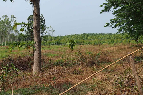
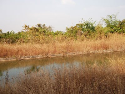
The site of the WW2 Hang Chat airstrip today Today there appears to be almost no evidence of the air facility on the ground at the locations as determined by the Allied intel sketch. Here are two current photos of the site of the westerly runway. This photo looks north from the south end of the westerly airstrip. There does not appear to be even a subtle change in elevation in the open field:[15]
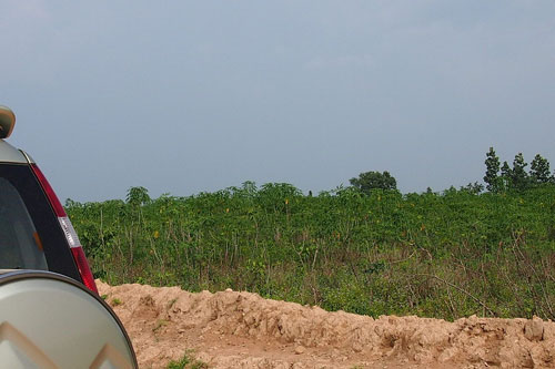
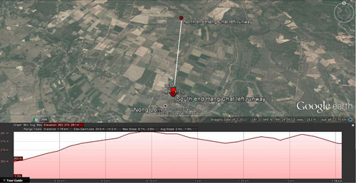
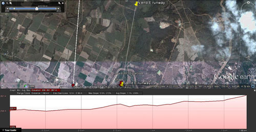
A larger image of the profile above is available here. The easterly runway is obscured by the subsequent addition of a major irrigation canal (khlong). Looking south from the elevated road adjacent to the khlong, along what is believed to have been the line of the runway:[17a1]
The profile for the easterly runway is pretty bumpy (but note that the khlong does not appear in the profile; if present it would show as a minor rise about 259 m north of the south end, which it does not):[17a3]
A larger image of the profile above is available here. The easterly runway seems peculiar in that while it was reported as completed first, its full length had not been sketched in. The roughness of the profiles is unusual --- if runways had ever been at those locations. Statistics of those profiles include:
In fact, the data is perplexing. Two possible solutions come to mind and each is only tentative: 1. Location of the runway was not plotted correctly. • Allied intel erred in preparing the map sketch; that would 2. The Japanese intentionally prepared a "dummy" airfield in an Conversely, another airfield was actually set up concurrently Further, no aircraft were ever reported on either Hang Chat runway. At this time, which explanation, if either, might be correct is unclear; and another alternative, not coincident with the Allied intel locations --- that of the eye witness on the ground, Maeson Wongtom --- should be considered.
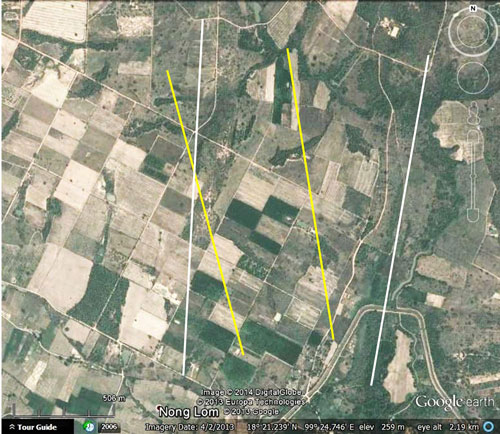
Maeson Wongmot's information must be considered largely fragmentary; however, extrapolating from what she provided, the possible tracks of the runways (the two yellow lines in the markup below) are possible, but not probable, when compared with those based on Allied intel reports (the two white lines). Of particular significance is Allied intel's text consistently describing the runways as having been separated by 500 yards (457 m). While the yellow lines conform to that criterion, the white lines, based on an Allied intel sketch, are separated by more than twice that distance on average, ie, 950 to 1150 m:[17b]
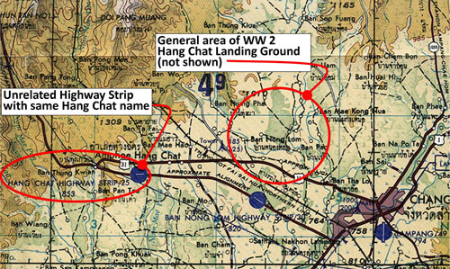
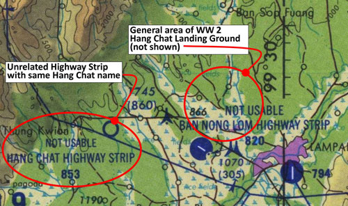
Name confusion --- the highway strip at Hang Chat: A Hang Chat Highway Strip[18] was established probably in the 1970s --- at least on paper. Its separate existence was unrelated to the Japanese Hang Chat airstrips. The Japanese airstrips never appeared in postwar flight maps. The highway strip first appeared in a 1973 flight map, as shown in the sequence below: 1958: the current right-of-way for Thai Route 11 roadway on which the highway strip is shown on later maps (and the roadway exists today), did not yet exist. It would have appeared south of and parallel to the railroad track coming out of Lampang:[19]
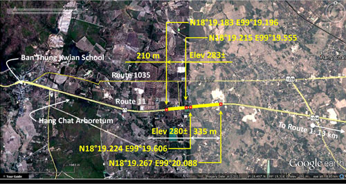
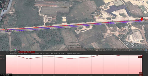
A current, Google Earth view of the immediate area suggests one of two possible locations which might have been planned for the highway strip. To the west of these locations, the highway grades are too steep to comfortably accommodate aircraft; to the east, a horizontal curve acts as a boundary for aircraft takeoffs and landings. The length of highway within those bounds include two sections of fairly level roadway, one at elevation 280±, the other at 283±:[22]
The easterly section (at elev 280) would have been just about long enough at 335 meters to have accommodated a de Havilland DHC-4 (US Army early designation YAC-1) which was popular amongst military forces during that period.[24] Were the two sections joined, a partially loaded C-130 could have used the resulting 550 meter stretch.[25]
|
13.^ This section added 29 May 2014. Steve Druzak's recollections (various emails starting 1711 14 May 2014) stirred me into looking at the USCG presence in Lampang. I had visited unknowingly the former LORAN site in Oct 2013 while looking for old government employees who might recall the IJAAF site. The visit was fruitless, but the comment had been made, perplexing at the time, that the buildings had once been occupied by US military personnel. 14.^ Air Facilities Data Thailand 432, (?: Air America, 01 Feb 1971), p 74.
15.^ PA070876.jpg
16.^ PA070886.jpg
17.^ Google Earth view of probable location of westerly Japanese Hang Chat airstrip, with a Google Earth "path" drawn on applicable section with option "show elevation profile" activated.
17a1.^ DSCF1647.jpg of 29 Jan 2014.
17a2.^ DSCF1648.jpg of 29 Jan 2014.
17a3.^ Google Earth view of probable location of easterly Japanese Hang Chat airstrip, with a Google Earth "path" drawn on applicable section with option "show elevation profile" activated.
17b.^ Google Earth view of Hang Chat area with possible runway locations indicated by superimposed lines. Annotation by author using Microsoft Publisher.
18.^ Wikipedia: A highway strip or road runway is a section of a highway or motorway that is specially built to allow landing of (mostly) military aircraft and to serve as a military airbase. These were built to allow military aircraft to operate even if their air bases, the most vulnerable targets in any war, are destroyed. In the Cold War highway strips were systematically built . . . . 19.^ Extract from map: "Indochina and Thailand 1:250,000", L509, Edition 1‑AMS (Washington: US Army Map Service, "First Printing, 5‑[19]58"). Annotations by author using Microsoft Publisher.
20.^ Extract from map: For record purposes, Ban Nong Lom Highway Strip would likely have been between about N18°18.960 E99°24.575 and N18°18.960 E99°24.575. While not flat, the gradient is absolute smooth per Google Earth "Show Elevation Profile" option. Annotations by author using Microsoft Publisher.
21.^ Extract from map: Annotations by author using Microsoft Publisher.
22.^ Extract from Google Earth showing possible Hang Chat highway strip sites.
23.^ Google Earth view of possible location of Hang Chat Highway Strip, with path drawn on applicable section and "show elevation profile" activated.
24.^ Wikipedia: 25.^Wikipedia:
|